Leo Petroglyph

Log in to your account

AroundUs is a community-driven map of interesting places, built by curious explorers like you. It grows with every review, story, and photo you share.
Connect to save your favorite spots, contribute locations, and create personalized routes.
Continue with Google
Continue with Apple
Continue with X
Continue with Facebook
Continue with email
By continuing, you accept our Terms and Conditions and our Privacy Policy
Create an account
Add to collection
Map
Suggest a change
Share

Leo Petroglyph, Archaeological site in Ray, Ohio, United States

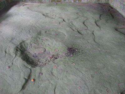
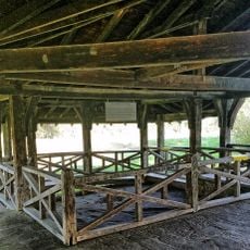
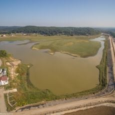
The Leo Petroglyph is an archaeological site featuring 37 ancient carvings on a flat sandstone slab depicting humans, birds, footprints, fish, and snakes. The carvings are protected by a shelter, and the site includes a half-mile walking trail through a gorge and picnic areas for visitors.

The carvings were created about 1,000 years ago by members of the Fort Ancient culture who lived in this region of Ohio. These stone carvings represent some of the surviving evidence of this ancient society and their time in the area.

The carvings depict figures that reflect the connection between early inhabitants and the natural world, showing spiritual and everyday elements of their lives. Visitors can observe how these images of people, animals, and ritual scenes capture what mattered most to the community that made them.

The site is easily accessible with a protective shelter covering the carvings and ample space for visitors to view them. The adjacent nature trail through the gorge helps visitors understand the landscape and provides a good way to explore the surrounding area during a visit.

The original carvings have been traced with charcoal to make them more visible for visitors today. This enhancement allows people to see the details of the ancient work more clearly when walking through the site.

Location: Ohio

Opening Hours: 24/7

GPS coordinates: 39.15079,-82.67497

Latest update: December 9, 2025 18:42

Photos
Around this place
Tar Hollow State Park
United States of America

Tar Hollow State Park

24.5 km
Zaleski State Forest
United States of America

Zaleski State Forest

29 km
Jackson Lake State Park
United States of America

Jackson Lake State Park

28.8 km
Zaleski Mound Group
United States of America

Zaleski Mound Group

28.5 km
Ponn Humpback Covered Bridge
United States of America

Ponn Humpback Covered Bridge

28.2 km
Harvey Wells House
United States of America

Harvey Wells House

12.8 km
United States of America

Vinton Furnace State Experimental Forest

25.5 km
Morgan Mansion
United States of America

Morgan Mansion

12.6 km
Johnson Road Covered Bridge
United States of America

Johnson Road Covered Bridge

23.5 km
Trinity Episcopal Church
United States of America

Trinity Episcopal Church

20 km
Clutts House
United States of America

Clutts House

12.5 km
Mt. Olive Road Covered Bridge
United States of America

Mt. Olive Road Covered Bridge

16.8 km
Eakin Mill Covered Bridge
United States of America

Eakin Mill Covered Bridge

29.3 km
Byer Covered Bridge
United States of America

Byer Covered Bridge

4.9 km
Ratcliffe Mound
United States of America

Ratcliffe Mound

18 km
Masonic Lodge No. 472
United States of America

Masonic Lodge No. 472

28.3 km
Buckeye Furnace Covered Bridge
United States of America

Buckeye Furnace Covered Bridge

21.5 km
Scioto Grange No. 1234
United States of America

Scioto Grange No. 1234

16.5 km
Ash Cave
United States of America

Ash Cave

29.9 km
Leo petroglyph
United States of America

Leo petroglyph

31 m
Lake White State Park
United States of America

Lake White State Park

30.3 km
Lake Katharine State Nature Preserve
United States of America

Lake Katharine State Nature Preserve

7.3 km
Scioto Trail State Park
United States of America

Scioto Trail State Park

25.4 km
Louvee Theatre
United States of America

Louvee Theatre

12.5 km
Trails
United States of America

Trails

11.3 km
Pike County Courthouse
United States of America

Pike County Courthouse

26.8 km
53rd O.V.I. Regiment
United States of America

53rd O.V.I. Regiment

11.4 km
Cox Covered Bridge
United States of America

Cox Covered Bridge

30.2 km
Show the full map
Reviews

Visited this place? Tap the stars to rate it and share your experience / photos with the community! Try now! You can cancel it anytime.

« Leo Petroglyph - Archaeological site in Ray, Ohio, United States » is provided by Around Us (aroundus.com). Images and texts are derived from Wikimedia project under a Creative Commons license. You are allowed to copy, distribute, and modify copies of this page, under the conditions set by the license, as long as this note is clearly visible.

Discover hidden gems everywhere you go!

From secret cafés to breathtaking viewpoints, skip the crowded tourist spots and find places that match your style. Our app makes it easy with voice search, smart filtering, route optimization, and insider tips from travelers worldwide. Download now for the complete mobile experience.

Around Us App Screenshot

A unique approach to discovering new places

Le Figaro

All the places worth exploring

France Info

A tailor-made excursion in just a few clicks

20 Minutes