Enable Location

We need your location to show you interesting places around you

Discover nearby places

Find interesting locations and hidden gems around you

Precise directions

Get accurate directions and distances to places

Your location is never shared with other users. It's only used when you tap the location button.

Little River Light

Log in to your account

Start exploring — it's free

Trusted by 61,565 travelers worldwide

Continue with Google
Continue with Apple
or

We will send you a code to connect

By continuing, you accept our Terms and Conditions and our Privacy Policy

Check your inbox

We've sent a pincode in your inbox. Please enter the code below.

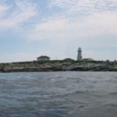
Little River Light, Maritime navigation lighthouse in Washington County, United States

Description

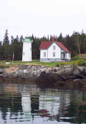
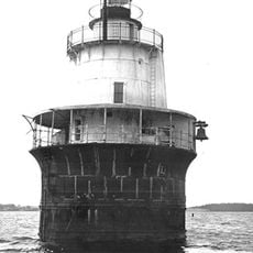
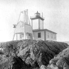
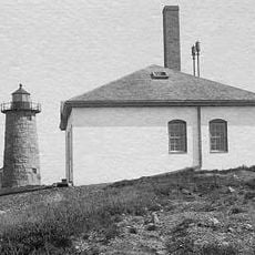
Little River Light is a lighthouse with an iron tower reinforced by a steel and brick framework located in Washington County. The structure stands 12 meters tall on a rocky point and has guided ships through challenging coastal waters for generations.

History

The original light was established in 1846 to warn ships of the hazardous rocks in this area. The current iron tower was built in 1876 by the United States Army Corps of Engineers as a replacement for the earlier structure.

Culture

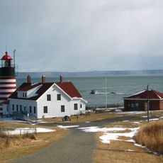
The lighthouse embodies Maine's seafaring traditions and remains a symbol of the region's maritime past. Visitors can feel this connection to the water and fishing heritage simply by standing near the tower and observing how it defines the coastal landscape.

Practical

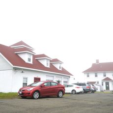
You can view the structure from outside, with the best views available from the water or nearby walking paths along the coast. The American Lighthouse Foundation offers overnight stays in the restored keeper's house during summer months for those who want a closer connection to the site.

Did you know?

It stands as one of the few remaining iron lighthouses in Maine, and during its 2001 restoration a Vega rotating beacon was installed to replace the original light. This modern beacon represents how the old structure continues to serve mariners with updated technology while keeping its historic character.

Inception
1846
Height
12 m
GPS coordinates
44.65089,-67.19210
Latest update
December 14, 2025 14:22

AroundUs brings together thousands of curated places, local tips, and hidden gems, enriched daily by 60,000 contributors worldwide. Discover all places nearby (Washington County).

Around this place
West Quoddy Head Light
United States of America

West Quoddy Head Light

26.4 km
Quoddy Head State Park
United States of America

Quoddy Head State Park

24.9 km
Cobscook Bay State Park
United States of America

Cobscook Bay State Park

21.5 km
Fort O'Brien
United States of America

Fort O'Brien

16.8 km
Machiasport Railroad “Lion”
United States of America

Machiasport Railroad “Lion”

21.8 km
Cross Island National Wildlife Refuge
United States of America

Cross Island National Wildlife Refuge

8.9 km
Roque Bluffs State Park
United States of America

Roque Bluffs State Park

23.8 km
Lubec Channel Light
United States of America

Lubec Channel Light

27.3 km
Avery Rock Light
United States of America

Avery Rock Light

12 km
Libby Island Light
United States of America

Libby Island Light

16.7 km
McCurdy Smokehouse
United States of America

McCurdy Smokehouse

28.6 km
Jeremiah Fowler House
United States of America

Jeremiah Fowler House

28.4 km
West Quoddy Lifesaving Station
United States of America

West Quoddy Lifesaving Station

25.8 km
Porter Memorial Library
United States of America

Porter Memorial Library

22.4 km
Machias Post Office and Customhouse
United States of America

Machias Post Office and Customhouse

22.3 km
Dennysville Historic District
United States of America

Dennysville Historic District

27.9 km
James R. Talbot House
United States of America

James R. Talbot House

18.5 km
Whitneyville Congregational Church
United States of America

Whitneyville Congregational Church

25.6 km
Clark Perry House
United States of America

Clark Perry House

22.5 km
Daniel Young House
United States of America

Daniel Young House

28.4 km
East Machias Historic District
United States of America

East Machias Historic District

18.3 km
Machias Valley Grange, No. 360
United States of America

Machias Valley Grange, No. 360

22.1 km
Gates House
United States of America

Gates House

16.8 km
Chaloner House
United States of America

Chaloner House

28.6 km
Washington County Courthouse
United States of America

Washington County Courthouse

22.4 km
Union Meeting House
United States of America

Union Meeting House

15.6 km
Machias Seal Island Lighthouse
Canada

Machias Seal Island Lighthouse

18.1 km
Liberty Hall
United States of America

Liberty Hall

16.8 km
Show the full map
« Little River Light - Maritime navigation lighthouse in Washington County, United States » is provided by Around Us (aroundus.com). Images and texts are derived from Wikimedia project under a Creative Commons license. You are allowed to copy, distribute, and modify copies of this page, under the conditions set by the license, as long as this note is clearly visible.

Discover hidden gems everywhere you go!

From secret cafés to breathtaking viewpoints, skip the crowded tourist spots and find places that match your style. Our app makes it easy with voice search, smart filtering, route optimization, and insider tips from travelers worldwide. Download now for the complete mobile experience.

Around Us App Screenshot

A unique approach to discovering new places

Le Figaro

All the places worth exploring

France Info

A tailor-made excursion in just a few clicks

20 Minutes

Around Us
Travel Guide & Maps
Download

Send to your phone

QR Code
1

Open the camera app on your mobile.

2

Point at the QR code with your camera. A notification will appear.

3

Tap the notification to open the link.