Enable Location

We need your location to show you interesting places around you

Discover nearby places

Find interesting locations and hidden gems around you

Precise directions

Get accurate directions and distances to places

Your location is never shared with other users. It's only used when you tap the location button.

Mays Island

Log in to your account

Start exploring — it's free

Trusted by 66,253 travelers worldwide

Continue with Google
Continue with Apple
or

We will send you a code to connect

By continuing, you accept our Terms and Conditions and our Privacy Policy

Check your inbox

We've sent a pincode in your inbox. Please enter the code below.

Discussion Reviews 1 Photos
3.2k Popularity

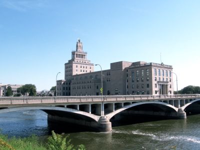
Mays Island, Historic district on river island in Cedar Rapids, United States.

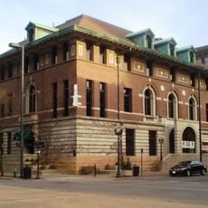
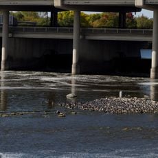
Mays Island is a historic district and river island in Cedar Rapids, Iowa, that serves as the administrative center for the city and Linn County. The island holds several government buildings, including the Memorial Building, the Linn County Courthouse, and a county jail, all surrounded by the Cedar River.

Jonathan May bought the island in the 1850s and convinced the Iowa State Legislature to rename the nearby settlement from Kingston to West Cedar Rapids. Over the following decades, government buildings gradually replaced the original landscape, turning it into the administrative center it is today.

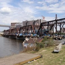
Mays Island sits in the middle of the Cedar River and draws residents from both sides of the city who come to handle official matters. Walking across one of the bridges to reach it gives a clear sense of how the island functions as a shared civic space.

The island is connected to different parts of Cedar Rapids by several bridges, making it easy to reach on foot. Most government buildings are open on weekdays, so that is the best time to walk around and get a sense of how the place works.

Before any government buildings went up, the low and marshy ground made the island a known hiding spot for horse thieves. Very few people walking between the courthouses today would guess at that earlier chapter.

The community of curious travelers

AroundUs brings together thousands of curated places, local tips, and hidden gems, enriched daily by 60,000 contributors worldwide.

Start exploring
Location
GPS coordinates
41.97583,-91.67028
Latest update
March 3, 2026 13:56
Around this place
Alliant Energy PowerHouse
United States of America

Alliant Energy PowerHouse

541 m
National Czech & Slovak Museum & Library
United States of America

National Czech & Slovak Museum & Library

1.3 km
Paramount Theatre
United States of America

Paramount Theatre

276 m
Peoples Savings Bank
United States of America

Peoples Savings Bank

212 m
Museum of Art Cedar Rapids
United States of America

Museum of Art Cedar Rapids

601 m
African American Museum of Iowa
United States of America

African American Museum of Iowa

1.2 km
Hotel Roosevelt
United States of America

Hotel Roosevelt

405 m
Linn County Courthouse
United States of America

Linn County Courthouse

104 m
C.S.P.S. Hall
United States of America

C.S.P.S. Hall

1.1 km
First Universalist Church of Cedar Rapids
United States of America

First Universalist Church of Cedar Rapids

812 m
Cedar Rapids Post Office and Public Building
United States of America

Cedar Rapids Post Office and Public Building

443 m
Cedar Rapids Scottish Rite Temple
United States of America

Cedar Rapids Scottish Rite Temple

911 m
Ausadie Building
United States of America

Ausadie Building

1.2 km
First Avenue Bridge
United States of America

First Avenue Bridge

186 m
George B. Douglas House
United States of America

George B. Douglas House

1 km
Lesinger Block
United States of America

Lesinger Block

1.3 km
Security Building
United States of America

Security Building

316 m
Grant Vocational High School
United States of America

Grant Vocational High School

597 m
Cedar Rapids 2nd Avenue SE. Automobile Row Historic District
United States of America

Cedar Rapids 2nd Avenue SE. Automobile Row Historic District

812 m
Glenn M. and Edith Averill House
United States of America

Glenn M. and Edith Averill House

835 m
Bethel African Methodist Church
United States of America

Bethel African Methodist Church

846 m
Highwater Rock
United States of America

Highwater Rock

339 m
Lattner Auditorium Building
United States of America

Lattner Auditorium Building

414 m
Iowa Building
United States of America

Iowa Building

469 m
UP Cedar River Bridge
United States of America

UP Cedar River Bridge

840 m
First Presbyterian Church Cedar Rapids
United States of America

First Presbyterian Church Cedar Rapids

636 m
Peoples Church Unitarian  Cedar Rapids
United States of America

Peoples Church Unitarian Cedar Rapids

756 m
Cedar River Tower
United States of America

Cedar River Tower

316 m
Show the full map
Reviews
Share your experience

No review yet

Discussions
Start a discussion...

No discussion yet

« Mays Island - Historic district on river island in Cedar Rapids, United States » is provided by Around Us (aroundus.com). Images and texts are derived from Wikimedia project under a Creative Commons license. You are allowed to copy, distribute, and modify copies of this page, under the conditions set by the license, as long as this note is clearly visible.

Discover hidden gems everywhere you go!

From secret cafés to breathtaking viewpoints, skip the crowded tourist spots and find places that match your style. Our app makes it easy with voice search, smart filtering, route optimization, and insider tips from travelers worldwide. Download now for the complete mobile experience.

Around Us App Screenshot

A unique approach to discovering new places

Le Figaro

All the places worth exploring

France Info

A tailor-made excursion in just a few clicks

20 Minutes

Around Us
Travel Guide & Maps
Download

Send to your phone

QR Code
1

Open the camera app on your mobile.

2

Point at the QR code with your camera. A notification will appear.

3

Tap the notification to open the link.