·

Enable Location

We need your location to show you interesting places around you

Discover nearby places

Find interesting locations and hidden gems around you

Precise directions

Get accurate directions and distances to places

Your location is never shared with other users. It's only used when you tap the location button.

Melvern Lake

Log in to your account

Start exploring — it's free

Trusted by 62,668 travelers worldwide

Continue with Google
Continue with Apple
or

We will send you a code to connect

By continuing, you accept our Terms and Conditions and our Privacy Policy

Check your inbox

We've sent a pincode in your inbox. Please enter the code below.

Melvern Lake

Melvern Lake, body of water

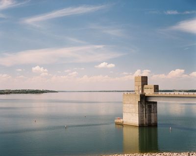
Melvern Lake is a large reservoir in Osage County, Kansas, created by damming the Marais des Cygnes River. The water body covers approximately 10.8 square miles and is managed by the U.S. Army Corps of Engineers.

The dam was completed in 1970 after the area suffered severe flooding for years, particularly during the major flood of 1951. The reservoir began filling by 1975 and has since protected downstream communities from flood damage while supporting recreation.

The reservoir has five parks along its shoreline - Outlet Park, Arrow Rock Park, Coeur d'Alene Park, Turkey Point Park, and Sun Dance Park - where visitors can fish, camp, and picnic. Access points are spread around the water, making it easy to find a spot suited to your plans.

The water is fed mainly by the Marais des Cygnes River, whose name means 'Swans' in French and reflects early European exploration of the region. The dam itself stands 188 feet high and stretches nearly 10,000 feet across, making it a significant structure of its era.

The community of curious travelers

AroundUs brings together thousands of curated places, local tips, and hidden gems, enriched daily by 60,000 contributors worldwide.

Start exploring
Location
GPS coordinates
38.51540,-95.71340
Latest update
February 7, 2026 11:40
Around this place
National Teachers Hall of Fame
United States of America

National Teachers Hall of Fame

42.2 km
David Traylor Zoo of Emporia
United States of America

David Traylor Zoo of Emporia

43.1 km
Dietrich Cabin
United States of America

Dietrich Cabin

40.2 km
Welch Stadium
United States of America

Welch Stadium

42.1 km
Old Depot Museum
United States of America

Old Depot Museum

40.3 km
Emporia Granada Theatre
United States of America

Emporia Granada Theatre

42.4 km
William Allen White House
United States of America

William Allen White House

41.9 km
Emporia State University Memorial Union
United States of America

Emporia State University Memorial Union

42 km
Peoples Bank Field
United States of America

Peoples Bank Field

40.5 km
Trusler Sports Complex
United States of America

Trusler Sports Complex

41.2 km
United States of America

Atchison, Topeka, and Santa Fe Pratt Truss Bridge

6.9 km
Tauy Jones Hall
United States of America

Tauy Jones Hall

40.4 km
Ottawa High School and Junior High School
United States of America

Ottawa High School and Junior High School

40.1 km
Franklin County Courthouse
United States of America

Franklin County Courthouse

40.3 km
Neosho River Bridge
United States of America

Neosho River Bridge

30.8 km
Burlington Carnegie Free Library
United States of America

Burlington Carnegie Free Library

35.7 km
Lyndon Carnegie Library
United States of America

Lyndon Carnegie Library

10.6 km
Burlington Opry
United States of America

Burlington Opry

35.8 km
Ottawa Library
United States of America

Ottawa Library

40.5 km
Arvonia School
United States of America

Arvonia School

14.1 km
St. Andrew's Episcopal Church
United States of America

St. Andrew's Episcopal Church

42.4 km
Walt Mason House
United States of America

Walt Mason House

43 km
Harris-Borman House
United States of America

Harris-Borman House

41.8 km
Osage County Courthouse
United States of America

Osage County Courthouse

10.9 km
Karnes Stone Barn
United States of America

Karnes Stone Barn

37 km
Richard Howe House
United States of America

Richard Howe House

42.5 km
Rocky Ford Bridge
United States of America

Rocky Ford Bridge

38.8 km
Historic Ottawa Central Business District
United States of America

Historic Ottawa Central Business District

40.3 km
Show the full map
« Melvern Lake - body of water » is provided by Around Us (aroundus.com). Images and texts are derived from Wikimedia project under a Creative Commons license. You are allowed to copy, distribute, and modify copies of this page, under the conditions set by the license, as long as this note is clearly visible.

Discover hidden gems everywhere you go!

From secret cafés to breathtaking viewpoints, skip the crowded tourist spots and find places that match your style. Our app makes it easy with voice search, smart filtering, route optimization, and insider tips from travelers worldwide. Download now for the complete mobile experience.

Around Us App Screenshot

A unique approach to discovering new places

Le Figaro

All the places worth exploring

France Info

A tailor-made excursion in just a few clicks

20 Minutes

Around Us
Travel Guide & Maps
Download

Send to your phone

QR Code
1

Open the camera app on your mobile.

2

Point at the QR code with your camera. A notification will appear.

3

Tap the notification to open the link.