Chest opened
+${chestReward.xp} XP
Explorer
NOUVEAU ×${chestReward.collectible.quantity}
tapez pour fermer
Chest locked

Open chests in the app

Around Us is built for your phone — chests unlock when you walk, explore and capture nearby places.

Enable Location

We need your location to show you interesting places around you

Discover nearby places

Find interesting locations and hidden gems around you

Precise directions

Get accurate directions and distances to places

Your location is never shared with other users. It's only used when you tap the location button.

Mole Hill

Log in to your account

Start exploring — it's free

Trusted by 72,891 travelers worldwide

Continue with Google
Continue with Apple
or

We will send you a code to connect

By continuing, you accept our Terms and Conditions and our Privacy Policy

Check your inbox

We've sent a pincode in your inbox. Please enter the code below.

Mole Hill
Discussion Reviews 1 Photos
10.6k Popularity

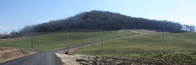
Mole Hill, Volcanic landform in Rockingham County, Virginia

Mole Hill is a volcanic landform in Rockingham County that rises approximately 577 meters (1,893 feet) above sea level. The dark basalt formation displays distinctive hexagonal columns created by ancient cooling lava.

This volcanic structure formed about 47 million years ago during the Eocene epoch. It remains one of the most recent volcanic formations along North America's eastern coast.

Mole Hill serves as a research site for James Madison University students and professors who study its geological composition and volcanic origins.

The hill sits west of Harrisonburg and attracts geology students and nature enthusiasts. Visitors should expect steep terrain and bring appropriate footwear for uneven ground.

The basalt surface contains green pyroxene and yellowish-brown olivine crystals visible when examining the rock. These minerals distinguish this formation from other volcanic structures along the eastern coast.

The community of curious travelers

AroundUs brings together thousands of curated places, local tips, and hidden gems, enriched daily by 60,000 contributors worldwide.

Start exploring
Location
GPS coordinates
38.44860,-78.95330
Latest update
December 10, 2025 15:53
Around this place
Bridgeforth Stadium and Zane Showker Field
United States of America

Bridgeforth Stadium and Zane Showker Field

7.1 km
Guns into Plowshares
United States of America

Guns into Plowshares

6.9 km
James Madison University Convocation Center
United States of America

James Madison University Convocation Center

7.6 km
Thomas Harrison House
United States of America

Thomas Harrison House

7.3 km
Joshua Wilton House
United States of America

Joshua Wilton House

7.3 km
Boxerwood Gardens
United States of America

Boxerwood Gardens

9.8 km
Woodrow Wilson Hall
United States of America

Woodrow Wilson Hall

7.1 km
Harrisonburg Downtown Historic District
United States of America

Harrisonburg Downtown Historic District

7.4 km
Lucy F. Simms School
United States of America

Lucy F. Simms School

8.3 km
Daniel Harrison House
United States of America

Daniel Harrison House

3.7 km
Anthony Hockman House
United States of America

Anthony Hockman House

7.7 km
Rockingham County Courthouse
United States of America

Rockingham County Courthouse

7.3 km
Turner Ashby Monument
United States of America

Turner Ashby Monument

8.2 km
Old Town Historic District
United States of America

Old Town Historic District

7.6 km
Massanetta Springs Historic District
United States of America

Massanetta Springs Historic District

11.6 km
Dayton Historic District
United States of America

Dayton Historic District

3.8 km
Bridgewater Historic District (Bridgewater, Virginia)
United States of America

Bridgewater Historic District (Bridgewater, Virginia)

7.7 km
Joseph Funk House
United States of America

Joseph Funk House

11.8 km
Singers Glen Historic District
United States of America

Singers Glen Historic District

10.4 km
Breneman-Turner Mill
United States of America

Breneman-Turner Mill

10.9 km
Signal Hill
United States of America

Signal Hill

78 m
Inglewood
United States of America

Inglewood

9.8 km
Peter Paul House
United States of America

Peter Paul House

2.4 km
John K. Beery Farm
United States of America

John K. Beery Farm

10.8 km
George Earman House
United States of America

George Earman House

5.4 km
Taylor Springs
United States of America

Taylor Springs

11.7 km
Explore More Discovery Museum
United States of America

Explore More Discovery Museum

7.4 km
ISAT Building
United States of America

ISAT Building

8 km
Show the full map
Reviews
Share your experience

No review yet

Discussions
Start a discussion...

No discussion yet

« Mole Hill - Volcanic landform in Rockingham County, Virginia » is provided by Around Us (aroundus.com). Images and texts are derived from Wikimedia project under a Creative Commons license. You are allowed to copy, distribute, and modify copies of this page, under the conditions set by the license, as long as this note is clearly visible.

Discover hidden gems everywhere you go!

From secret cafés to breathtaking viewpoints, skip the crowded tourist spots and find places that match your style. Our app makes it easy with voice search, smart filtering, route optimization, and insider tips from travelers worldwide. Download now for the complete mobile experience.

Around Us App Screenshot

A unique approach to discovering new places

Le Figaro

All the places worth exploring

France Info

A tailor-made excursion in just a few clicks

20 Minutes

Around Us
Travel Guide & Maps
Download

Send to your phone

QR Code
1

Open the camera app on your mobile.

2

Point at the QR code with your camera. A notification will appear.

3

Tap the notification to open the link.