Mood's Covered Bridge

Log in to your account

AroundUs is a community-driven map of interesting places, built by curious explorers like you. It grows with every review, story, and photo you share.
Connect to save your favorite spots, contribute locations, and create personalized routes.
Continue with Google
Continue with Apple
Continue with X
Continue with Facebook
Continue with email
By continuing, you accept our Terms and Conditions and our Privacy Policy
Create an account
Add to collection
Map
Suggest a change
Share

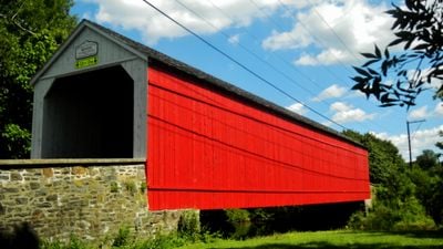
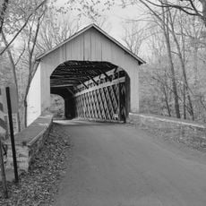
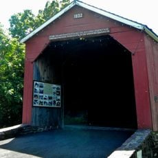
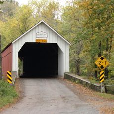
Mood's Covered Bridge, Covered bridge in East Rockhill Township, US.

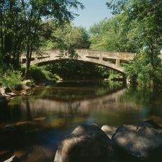
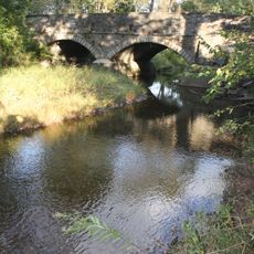
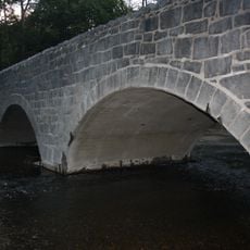
Mood's Covered Bridge is a wooden structure crossing the East Branch Perkiomen Creek, built using a town truss design that was common in regional bridge construction. The structure has been rebuilt to handle both cars and pedestrians on the rural road it serves.

The bridge was built in 1874 to meet the transportation needs of the surrounding area and earned official historic recognition in 1980. A fire in 2004 destroyed the original structure, prompting its complete reconstruction.

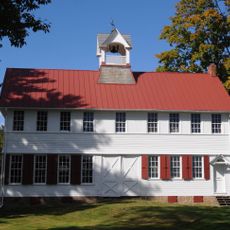
The bridge represents how rural communities relied on wooden structures to connect their lands and commerce. Today it stands as a marker of settlement patterns in the region.

The bridge sits on a local road and is accessible by car for visitors exploring the rural area. It is best viewed during daylight hours to appreciate the wooden structure and surrounding landscape.

After its destruction in 2004, the bridge was rebuilt with careful attention to historical standards. Those responsible for the fire were required to contribute financially to its reconstruction, an unusual resolution.

Location: East Rockhill Township

GPS coordinates: 40.38120,-75.27164

Latest update: December 14, 2025 16:40

Photos
Around this place
Nockamixon State Park
United States of America

Nockamixon State Park

4.5 km
Peace Valley Park
United States of America

Peace Valley Park

9.3 km
Green Hills Farm
United States of America

Green Hills Farm

5 km
United States of America

Musser Scout Reservation

13.7 km
Fordhook Farm
United States of America

Fordhook Farm

13.9 km
Liberty Hall
United States of America

Liberty Hall

9.7 km
Lake Towhee Park
United States of America

Lake Towhee Park

10.8 km
Loux Covered Bridge
United States of America

Loux Covered Bridge

13.1 km
South Perkasie Covered Bridge
United States of America

South Perkasie Covered Bridge

2.5 km
Doylestown Historic District
United States of America

Doylestown Historic District

13.9 km
Pine Valley Covered Bridge
United States of America

Pine Valley Covered Bridge

11 km
Quakertown Historic District
United States of America

Quakertown Historic District

9 km
Campbell's Bridge
United States of America

Campbell's Bridge

12 km
Uneek Havana Cigar Company
United States of America

Uneek Havana Cigar Company

2.3 km
Henry Schmieder Arboretum
United States of America

Henry Schmieder Arboretum

13.3 km
Sheard's Mill Covered Bridge
United States of America

Sheard's Mill Covered Bridge

8.2 km
Klein Meetinghouse
United States of America

Klein Meetinghouse

13.3 km
Bridge in Franconia Township
United States of America

Bridge in Franconia Township

11.8 km
Bridge in Hatfield Township
United States of America

Bridge in Hatfield Township

10.8 km
Sutch Road Bridge in Marlborough Township
United States of America

Sutch Road Bridge in Marlborough Township

13 km
Chalfont Historic District
United States of America

Chalfont Historic District

11.4 km
Enoch Roberts House
United States of America

Enoch Roberts House

9.6 km
Morgan James Homestead
United States of America

Morgan James Homestead

10.4 km
Landis Homestead
United States of America

Landis Homestead

13.7 km
Dyerstown Historic District
United States of America

Dyerstown Historic District

13.1 km
Gardenville-North Branch Rural Historic District
United States of America

Gardenville-North Branch Rural Historic District

13.2 km
Shaw Historic District
United States of America

Shaw Historic District

13.9 km
Pearl S. Buck National Historic Landmark
United States of America

Pearl S. Buck National Historic Landmark

5.3 km
Show the full map
Reviews

Visited this place? Tap the stars to rate it and share your experience / photos with the community! Try now! You can cancel it anytime.

« Mood's Covered Bridge - Covered bridge in East Rockhill Township, US » is provided by Around Us (aroundus.com). Images and texts are derived from Wikimedia project under a Creative Commons license. You are allowed to copy, distribute, and modify copies of this page, under the conditions set by the license, as long as this note is clearly visible.

Discover hidden gems everywhere you go!

From secret cafés to breathtaking viewpoints, skip the crowded tourist spots and find places that match your style. Our app makes it easy with voice search, smart filtering, route optimization, and insider tips from travelers worldwide. Download now for the complete mobile experience.

Around Us App Screenshot

A unique approach to discovering new places

Le Figaro

All the places worth exploring

France Info

A tailor-made excursion in just a few clicks

20 Minutes