Enable Location

We need your location to show you interesting places around you

Discover nearby places

Find interesting locations and hidden gems around you

Precise directions

Get accurate directions and distances to places

Your location is never shared with other users. It's only used when you tap the location button.

South Perkasie Covered Bridge

Log in to your account

Start exploring — it's free

Trusted by 61,899 travelers worldwide

Continue with Google
Continue with Apple
or

We will send you a code to connect

By continuing, you accept our Terms and Conditions and our Privacy Policy

Check your inbox

We've sent a pincode in your inbox. Please enter the code below.

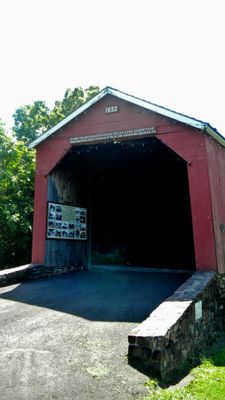
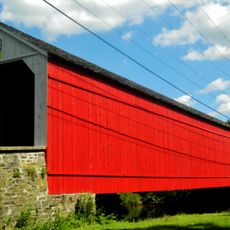
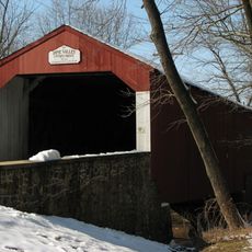
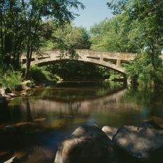
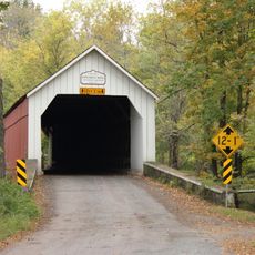
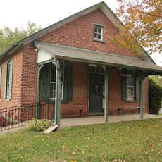
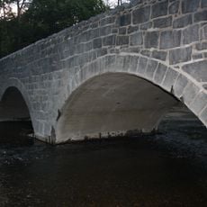
South Perkasie Covered Bridge, Covered bridge in Perkasie, Pennsylvania.

The South Perkasie Covered Bridge is a wooden structure that crosses Pleasant Spring Creek, built with traditional Town truss construction that has stood for nearly two centuries. Its covered design protects the wooden frame from weather and decay, a common feature of bridges from this era.

The bridge was constructed in 1832 using traditional engineering methods of that time and later moved to its current location in Lenape Park during 1959. This relocation helped preserve the structure and made it more accessible to the public.

The bridge serves as a gathering place for the community, especially during local celebrations and festivals throughout the year. It represents how people value their shared history and use it as a focal point for coming together.

The bridge is best reached through Lenape Park, which has parking areas and walking paths nearby. The location works well for a leisurely walk and provides good access to the structure and the surrounding environment.

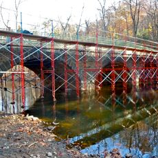
Hurricane Ida caused major damage to the structure in September 2021, but extensive restoration work brought it back to its original condition. The careful repairs show how much effort the community put into saving this historical piece.

The community of curious travelers

AroundUs brings together thousands of curated places, local tips, and hidden gems, enriched daily by 60,000 contributors worldwide.

Start exploring
Location
GPS coordinates
40.36750,-75.29530
Latest update
December 14, 2025 17:04
Around this place
Nockamixon State Park
United States of America

Nockamixon State Park

6.6 km
Peace Valley Park
United States of America

Peace Valley Park

10.1 km
Green Hills Farm
United States of America

Green Hills Farm

6.5 km
Edward Morgan Log House
United States of America

Edward Morgan Log House

13.7 km
United States of America

Musser Scout Reservation

11.6 km
Perkasie Tunnel
United States of America

Perkasie Tunnel

1.4 km
Liberty Hall
United States of America

Liberty Hall

9.7 km
Lake Towhee Park
United States of America

Lake Towhee Park

12.5 km
Mood's Covered Bridge
United States of America

Mood's Covered Bridge

2.5 km
Pine Valley Covered Bridge
United States of America

Pine Valley Covered Bridge

11.5 km
Swamp Creek Road Bridge
United States of America

Swamp Creek Road Bridge

13.6 km
Quakertown Historic District
United States of America

Quakertown Historic District

9.1 km
Campbell's Bridge
United States of America

Campbell's Bridge

11.1 km
Uneek Havana Cigar Company
United States of America

Uneek Havana Cigar Company

3.8 km
Henry Schmieder Arboretum
United States of America

Henry Schmieder Arboretum

13.9 km
Sheard's Mill Covered Bridge
United States of America

Sheard's Mill Covered Bridge

9.8 km
Andreas Rieth Homestead
United States of America

Andreas Rieth Homestead

13.9 km
Klein Meetinghouse
United States of America

Klein Meetinghouse

10.9 km
Bridge in Franconia Township
United States of America

Bridge in Franconia Township

9.5 km
Bridge in Hatfield Township
United States of America

Bridge in Hatfield Township

9.5 km
Shelly School
United States of America

Shelly School

9.9 km
Sutch Road Bridge in Marlborough Township
United States of America

Sutch Road Bridge in Marlborough Township

10.9 km
Bergy Bridge Historic District
United States of America

Bergy Bridge Historic District

13 km
Chalfont Historic District
United States of America

Chalfont Historic District

11.2 km
Enoch Roberts House
United States of America

Enoch Roberts House

9.6 km
Morgan James Homestead
United States of America

Morgan James Homestead

10.6 km
Landis Homestead
United States of America

Landis Homestead

11.2 km
Pearl S. Buck National Historic Landmark
United States of America

Pearl S. Buck National Historic Landmark

6.8 km
Show the full map
« South Perkasie Covered Bridge - Covered bridge in Perkasie, Pennsylvania » is provided by Around Us (aroundus.com). Images and texts are derived from Wikimedia project under a Creative Commons license. You are allowed to copy, distribute, and modify copies of this page, under the conditions set by the license, as long as this note is clearly visible.

Discover hidden gems everywhere you go!

From secret cafés to breathtaking viewpoints, skip the crowded tourist spots and find places that match your style. Our app makes it easy with voice search, smart filtering, route optimization, and insider tips from travelers worldwide. Download now for the complete mobile experience.

Around Us App Screenshot

A unique approach to discovering new places

Le Figaro

All the places worth exploring

France Info

A tailor-made excursion in just a few clicks

20 Minutes

Around Us
Travel Guide & Maps
Download

Send to your phone

QR Code
1

Open the camera app on your mobile.

2

Point at the QR code with your camera. A notification will appear.

3

Tap the notification to open the link.