Enable Location

We need your location to show you interesting places around you

Discover nearby places

Find interesting locations and hidden gems around you

Precise directions

Get accurate directions and distances to places

Your location is never shared with other users. It's only used when you tap the location button.

Myre-Big Island State Park

Log in to your account

Start exploring — it's free

Trusted by 65,008 travelers worldwide

Continue with Google
Continue with Apple
or

We will send you a code to connect

By continuing, you accept our Terms and Conditions and our Privacy Policy

Check your inbox

We've sent a pincode in your inbox. Please enter the code below.

Myre-Big Island State Park
Discussion Reviews 1 Photos
4.4k Popularity

Myre-Big Island State Park, State park in Freeborn County, Minnesota, US

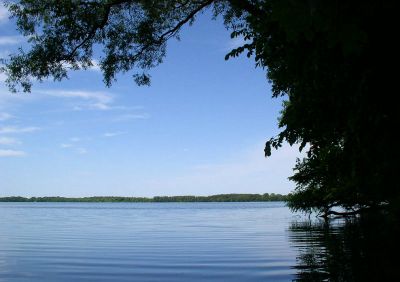
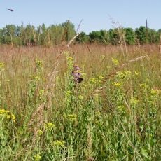
Myre-Big Island State Park is a Minnesota state park in Freeborn County, in the southern part of the state, set around Albert Lea Lake. The terrain combines wetlands, mixed woodland, and open grassland on gently rolling ground.

The area was designated a state park in 1947, when much of the land had previously been used for farming. Over the following decades, former fields were gradually returned to a more natural state.

The park takes part of its name from Big Island, a landmass in Albert Lea Lake that visitors can reach on foot via a connecting trail. Fishing is a strong local tradition here, and the lake draws anglers throughout the open-water season.

The park is open year-round, with hiking and cycling trails in the warmer months and cross-country skiing and snowshoeing routes in winter. Dress for the season and carry water, as facilities along the trails are limited.

The park carries two names because it was formed by merging two separate protected areas: Myre State Park and Big Island State Park were combined in 1973. That merger is the reason for the double name that still appears on maps and signs today.

The community of curious travelers

AroundUs brings together thousands of curated places, local tips, and hidden gems, enriched daily by 60,000 contributors worldwide.

Start exploring
Location
Inception
1947
GPS coordinates
43.63580,-93.30890
Latest update
March 3, 2026 08:10
Around this place
Spam Museum
United States of America

Spam Museum

27.2 km
Pilot Knob State Park
United States of America

Pilot Knob State Park

47.5 km
Hormel Historic Home
United States of America

Hormel Historic Home

27 km
St. Augustine's Church
United States of America

St. Augustine's Church

26.8 km
Paramount Theater
United States of America

Paramount Theater

27.3 km
Jay C. Hormel Nature Center
United States of America

Jay C. Hormel Nature Center

30.4 km
East Side Lake
United States of America

East Side Lake

29 km
First Lutheran Church
United States of America

First Lutheran Church

42.1 km
Lodge Zare Zapadu
United States of America

Lodge Zare Zapadu

11.7 km
Clarks Grove Cooperative Creamery
United States of America

Clarks Grove Cooperative Creamery

14.3 km
Vista Lutheran Church
United States of America

Vista Lutheran Church

37.9 km
Rhodes Mill
United States of America

Rhodes Mill

42.4 km
Bessesen Building
United States of America

Bessesen Building

5 km
Worth County Courthouse
United States of America

Worth County Courthouse

22.5 km
First Methodist Episcopal Church
United States of America

First Methodist Episcopal Church

32.6 km
Otranto Bridge
United States of America

Otranto Bridge

33 km
Winnebago River Bridge
United States of America

Winnebago River Bridge

49.9 km
Winnebago County Courthouse
United States of America

Winnebago County Courthouse

49.3 km
Peter Kremer House
United States of America

Peter Kremer House

48 km
Union Presbyterian Church
United States of America

Union Presbyterian Church

43.9 km
First National Bank of Adams
United States of America

First National Bank of Adams

48.2 km
Northwood Central Avenue Historic District
United States of America

Northwood Central Avenue Historic District

22.2 km
Charles J. Thompson House
United States of America

Charles J. Thompson House

49 km
Strangers Refuge Lodge Number 74, IOOF
United States of America

Strangers Refuge Lodge Number 74, IOOF

32.2 km
Blooming Prairie Commercial Historic District
United States of America

Blooming Prairie Commercial Historic District

33 km
Old Worth County Courthouse
United States of America

Old Worth County Courthouse

22.6 km
Hormel Historic Home
United States of America

Hormel Historic Home

27 km
Mitchell County Courthouse
United States of America

Mitchell County Courthouse

50.1 km
Show the full map
Reviews
Share your experience

No review yet

Discussions
Start a discussion...

No discussion yet

« Myre-Big Island State Park - State park in Freeborn County, Minnesota, US » is provided by Around Us (aroundus.com). Images and texts are derived from Wikimedia project under a Creative Commons license. You are allowed to copy, distribute, and modify copies of this page, under the conditions set by the license, as long as this note is clearly visible.

Discover hidden gems everywhere you go!

From secret cafés to breathtaking viewpoints, skip the crowded tourist spots and find places that match your style. Our app makes it easy with voice search, smart filtering, route optimization, and insider tips from travelers worldwide. Download now for the complete mobile experience.

Around Us App Screenshot

A unique approach to discovering new places

Le Figaro

All the places worth exploring

France Info

A tailor-made excursion in just a few clicks

20 Minutes

Around Us
Travel Guide & Maps
Download

Send to your phone

QR Code
1

Open the camera app on your mobile.

2

Point at the QR code with your camera. A notification will appear.

3

Tap the notification to open the link.