North Manitou Island Lifesaving Station

Log in to your account

AroundUs is a community-driven map of interesting places, built by curious explorers like you. It grows with every review, story, and photo you share.
Connect to save your favorite spots, contribute locations, and create personalized routes.
Continue with Google
Continue with Apple
Continue with X
Continue with Facebook
Continue with email
By continuing, you accept our Terms and Conditions and our Privacy Policy
Create an account
Add to collection
Map
Suggest a change
Share

North Manitou Island Lifesaving Station, Historic lifesaving station in Sleeping Bear Dunes National Lakeshore, Michigan.

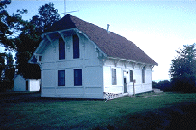
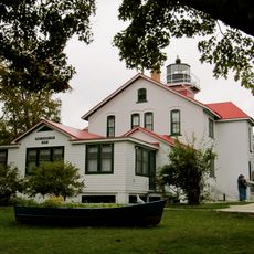
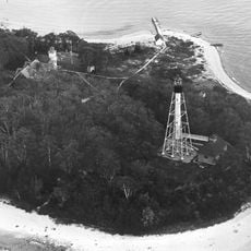
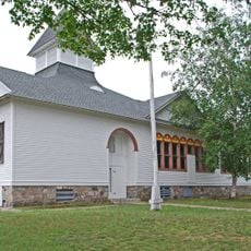
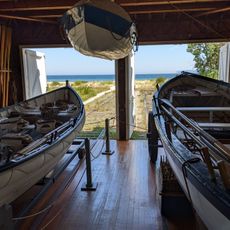
North Manitou Island Lifesaving Station is a historic rescue post on the northeastern shore of the island, containing multiple structures spread across roughly 3 acres of land. The complex includes a boathouse, crew quarters, and other buildings that illustrate the infrastructure needed to support maritime emergency operations on the Great Lakes.

The station was established in 1854 with congressional funding as a volunteer rescue operation before eventually being run by the Life-Saving Service and later the Coast Guard. It remained operational until 1932, serving as a vital rescue point on the Great Lakes until it was decommissioned.

The structures show how rescue crews lived and worked on these shores during the 1800s, offering a glimpse into the daily rhythms of their maritime duties. You can observe the strong connection between the station and the Great Lakes, understanding how such posts shaped the region's relationship with water-based emergencies.

The site can only be reached by boat, so plan your visit by checking ferry schedules from nearby mainland docks beforehand. Once there, you will find National Park Service displays that explain how rescue operations worked on the Great Lakes.

The 1854 boathouse stands as the only surviving building constructed according to standardized government blueprints designed for volunteer rescue stations across the country. This structure reveals how the federal government sought to build consistent rescue infrastructure nationwide during that era.

Location: Michigan

GPS coordinates: 45.12111,-85.97750

Latest update: December 14, 2025 18:07

Photos
Around this place
Glen Haven, Michigan
United States of America

Glen Haven, Michigan

25.1 km
Leelanau State Park
United States of America

Leelanau State Park

33.4 km
Bowers Harbor Inn
United States of America

Bowers Harbor Inn

44 km
South Manitou Island Lighthouse
United States of America

South Manitou Island Lighthouse

15.6 km
Grand Traverse Light
United States of America

Grand Traverse Light

35 km
South Fox Island Light
United States of America

South Fox Island Light

30.7 km
Port Oneida Rural Historic District
United States of America

Port Oneida Rural Historic District

23.4 km
Leland Historic District
United States of America

Leland Historic District

20.2 km
SS Jarvis Lord
United States of America

SS Jarvis Lord

17.6 km
North Manitou Shoal Light Station
United States of America

North Manitou Shoal Light Station

11.4 km
Grove Hill New Mission Church
United States of America

Grove Hill New Mission Church

31.6 km
Saint Joseph's Catholic Church
United States of America

Saint Joseph's Catholic Church

26.3 km
Fountain Point
United States of America

Fountain Point

27.2 km
Empire School
United States of America

Empire School

35.1 km
Dougherty Mission House
United States of America

Dougherty Mission House

42.4 km
William and Margaret McFarland Core Farm
United States of America

William and Margaret McFarland Core Farm

34.2 km
Old Mission Inn
United States of America

Old Mission Inn

42.3 km
Lake Leelanau Narrows Bridge
United States of America

Lake Leelanau Narrows Bridge

26.1 km
George Conrad Hutzler Farm
United States of America

George Conrad Hutzler Farm

16 km
Hutzler's Barn
United States of America

Hutzler's Barn

14.2 km
Omena Historic District
United States of America

Omena Historic District

31.5 km
Bingham District No. 5 Schoolhouse
United States of America

Bingham District No. 5 Schoolhouse

36.2 km
Boathouse #2
United States of America

Boathouse #2

24.1 km
Mission Point Light
United States of America

Mission Point Light

41.7 km
Manning Memorial Light
United States of America

Manning Memorial Light

34.9 km
Bay Theatre
United States of America

Bay Theatre

30.3 km
Leland Historic District (Fishtown) Historical Marker
United States of America

Leland Historic District (Fishtown) Historical Marker

20.2 km
Fishtown Historic District
United States of America

Fishtown Historic District

20.2 km
Show the full map
Reviews

Visited this place? Tap the stars to rate it and share your experience / photos with the community! Try now! You can cancel it anytime.

« North Manitou Island Lifesaving Station - Historic lifesaving station in Sleeping Bear Dunes National Lakeshore, Michigan » is provided by Around Us (aroundus.com). Images and texts are derived from Wikimedia project under a Creative Commons license. You are allowed to copy, distribute, and modify copies of this page, under the conditions set by the license, as long as this note is clearly visible.

Discover hidden gems everywhere you go!

From secret cafés to breathtaking viewpoints, skip the crowded tourist spots and find places that match your style. Our app makes it easy with voice search, smart filtering, route optimization, and insider tips from travelers worldwide. Download now for the complete mobile experience.

Around Us App Screenshot

A unique approach to discovering new places

Le Figaro

All the places worth exploring

France Info

A tailor-made excursion in just a few clicks

20 Minutes