Enable Location

We need your location to show you interesting places around you

Discover nearby places

Find interesting locations and hidden gems around you

Precise directions

Get accurate directions and distances to places

Your location is never shared with other users. It's only used when you tap the location button.

Norton Reservoir

Log in to your account

Start exploring — it's free

Trusted by 62,901 travelers worldwide

Continue with Google
Continue with Apple
or

We will send you a code to connect

By continuing, you accept our Terms and Conditions and our Privacy Policy

Check your inbox

We've sent a pincode in your inbox. Please enter the code below.

Norton Reservoir
Discussion Reviews 1 Photos
2.5k Popularity

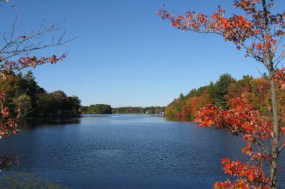
Norton Reservoir, body of water

Norton Reservoir is a shallow body of water in Norton, Massachusetts, used mainly for fishing and recreation. The bottom is mostly hard sand with a deeper area near the dam reaching about 10 feet deep, while water clarity varies seasonally and remains murky for most of the year.

The reservoir was created by damming a natural stream, reshaping the landscape for fishing and recreation purposes. In 2016, the town conducted a weed removal operation to improve water access and clarity, which fundamentally changed conditions in the water and fish habitats.

The reservoir is named after the town of Norton in Massachusetts. It serves as a gathering place where local anglers and visitors share fishing stories and respect the natural surroundings as part of their outdoor traditions.

The water is easy to access from several spots around the edges and can often be waded without a boat since the hard sand bottom prevents sinking. A boat ramp is available for small boats, and the shallow water makes it simple to fish from the shoreline.

After the 2016 weed removal, the aquatic plants that once provided habitat for smaller fish disappeared, changing fishing quality over time. This ecological shift demonstrates how cleanup projects can have unintended consequences on the natural balance of the water.

The community of curious travelers

AroundUs brings together thousands of curated places, local tips, and hidden gems, enriched daily by 60,000 contributors worldwide.

Start exploring
Location
GPS coordinates
41.98333,-71.18944
Latest update
February 9, 2026 08:22
Around this place
Xfinity Center
United States of America

Xfinity Center

2.7 km
Capron Park Zoo
United States of America

Capron Park Zoo

10.3 km
United States of America

King Phillip's Cave

4.9 km
Bay Road
United States of America

Bay Road

6.4 km
Watson Pond State Park
United States of America

Watson Pond State Park

7.3 km
Briggs Tavern
United States of America

Briggs Tavern

9.2 km
Blackinton Houses and Park
United States of America

Blackinton Houses and Park

9.2 km
Fisher-Richardson House
United States of America

Fisher-Richardson House

4.4 km
Taunton Alms House
United States of America

Taunton Alms House

8.6 km
Ezra Carpenter House
United States of America

Ezra Carpenter House

9.4 km
East Attleborough Academy
United States of America

East Attleborough Academy

8.9 km
Capron House
United States of America

Capron House

9.5 km
First Parsonage for Second East Parish Church
United States of America

First Parsonage for Second East Parish Church

9.1 km
Cottage-Freeman Historic District
United States of America

Cottage-Freeman Historic District

10.2 km
Furnace Village Historic District
United States of America

Furnace Village Historic District

6.5 km
Otis Cary House
United States of America

Otis Cary House

9 km
Hodges House
United States of America

Hodges House

7.8 km
Capt. Josiah Pratt House
United States of America

Capt. Josiah Pratt House

9 km
Gen. Thomas Lincoln House
United States of America

Gen. Thomas Lincoln House

8.1 km
Commonwealth Avenue Historic District
United States of America

Commonwealth Avenue Historic District

10.1 km
Pitt Clarke House
United States of America

Pitt Clarke House

1.5 km
Brow's Tavern
United States of America

Brow's Tavern

9.6 km
Soldiers' Memorial Library
United States of America

Soldiers' Memorial Library

5 km
Norton Center Historic District
United States of America

Norton Center Historic District

1.8 km
Towne Street Historic District
United States of America

Towne Street Historic District

10.2 km
Bay Road
United States of America

Bay Road

6.4 km
Splash Pad
United States of America

Splash Pad

10.3 km
Old Attleboro Post Office
United States of America

Old Attleboro Post Office

8.8 km
Show the full map
« Norton Reservoir - body of water » is provided by Around Us (aroundus.com). Images and texts are derived from Wikimedia project under a Creative Commons license. You are allowed to copy, distribute, and modify copies of this page, under the conditions set by the license, as long as this note is clearly visible.

Discover hidden gems everywhere you go!

From secret cafés to breathtaking viewpoints, skip the crowded tourist spots and find places that match your style. Our app makes it easy with voice search, smart filtering, route optimization, and insider tips from travelers worldwide. Download now for the complete mobile experience.

Around Us App Screenshot

A unique approach to discovering new places

Le Figaro

All the places worth exploring

France Info

A tailor-made excursion in just a few clicks

20 Minutes

Around Us
Travel Guide & Maps
Download

Send to your phone

QR Code
1

Open the camera app on your mobile.

2

Point at the QR code with your camera. A notification will appear.

3

Tap the notification to open the link.