Enable Location

We need your location to show you interesting places around you

Discover nearby places

Find interesting locations and hidden gems around you

Precise directions

Get accurate directions and distances to places

Your location is never shared with other users. It's only used when you tap the location button.

Pierre Shale

Log in to your account

Start exploring — it's free

Trusted by 65,317 travelers worldwide

Continue with Google
Continue with Apple
or

We will send you a code to connect

By continuing, you accept our Terms and Conditions and our Privacy Policy

Check your inbox

We've sent a pincode in your inbox. Please enter the code below.

Discussion Reviews 1 Photos
10.6k Popularity

Pierre Shale, Geological formation in South Dakota and North Dakota, United States and Alberta, Canada

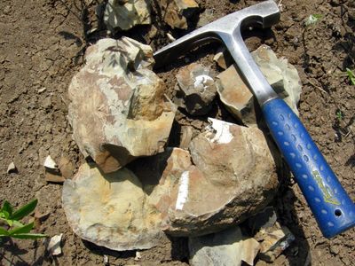
Pierre Shale is a geological formation made of gray and olive-colored shale that runs across parts of South Dakota, North Dakota, and into Alberta in Canada. Where the rock breaks through the surface, alternating layers of siltstone and sandstone create visible bands in the exposed cliffs and hillsides.

The formation was first described in 1862 by geologists F.B. Meek and F.V. Hayden, who called it Formation No. 5 in their early surveys of the region. The name was later changed to reflect its connection to the city of Pierre and to set it apart from other nearby rock units.

The name comes from the city of Pierre in South Dakota, where these rock layers are especially visible at the surface. The exposed outcrops draw fossil hunters and geology enthusiasts who come specifically to look for marine remains in the gray stone.

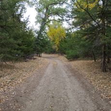
The layers are easiest to see where the rock is exposed at the surface along roadsides, river banks, or open hillsides, without needing a long walk. Going with someone who knows the local geology helps you make sense of the different bands and what they tell you about the ground beneath.

These rock layers formed at the bottom of a shallow inland sea that covered much of central North America around 70 million years ago. Because of this, the gray stone sometimes contains fossils of marine reptiles and shellfish, which visitors occasionally spot directly in exposed outcrops.

The community of curious travelers

AroundUs brings together thousands of curated places, local tips, and hidden gems, enriched daily by 60,000 contributors worldwide.

Start exploring
Made from material
shale
GPS coordinates
44.39500,-100.41200
Latest update
March 10, 2026 22:31
Around this place
Lake Oahe
United States of America

Lake Oahe

6.3 km
South Dakota Governor's Residence
United States of America

South Dakota Governor's Residence

6.6 km
South Dakota State Capitol
United States of America

South Dakota State Capitol

6.1 km
Fort Pierre Chouteau
United States of America

Fort Pierre Chouteau

1.8 km
United States of America

Farm Island Recreation Area

12.6 km
Verendrye Site
United States of America

Verendrye Site

5.1 km
Chicago and North Western Railroad Bridge
United States of America

Chicago and North Western Railroad Bridge

4.1 km
United States of America

South Dakota Cultural Heritage Center

6.4 km
Hughes County Courthouse
United States of America

Hughes County Courthouse

5.6 km
I. W. Goodner House
United States of America

I. W. Goodner House

5.2 km
Peter Hansen House
United States of America

Peter Hansen House

6.5 km
St. Charles Hotel
United States of America

St. Charles Hotel

5.8 km
Farr House
United States of America

Farr House

5.7 km
Dr. William and Elizabeth Blackburn House
United States of America

Dr. William and Elizabeth Blackburn House

7.7 km
Pierre Masonic Lodge
United States of America

Pierre Masonic Lodge

27.8 km
Fort Pierre Congregational Church
United States of America

Fort Pierre Congregational Church

5.5 km
Brink-Wegner House
United States of America

Brink-Wegner House

5.3 km
Central Block
United States of America

Central Block

5.6 km
Karcher–Sahr House
United States of America

Karcher–Sahr House

6 km
John E. and Ruth Hipple House
United States of America

John E. and Ruth Hipple House

5.8 km
Jefferson Davis Carr House
United States of America

Jefferson Davis Carr House

5.3 km
Crawford–Pettyjohn House
United States of America

Crawford–Pettyjohn House

7 km
Horner–Hyde House
United States of America

Horner–Hyde House

5.6 km
Methodist Episcopal Church
United States of America

Methodist Episcopal Church

5.4 km
LaFramboise Island Nature Area
United States of America

LaFramboise Island Nature Area

7.4 km
United States of America

East Shore Recreation Area

8.2 km
United States of America

Hillsview Golf Club

10.3 km
United States of America

Dunes Golf Course

2.3 km
Show the full map
Reviews
Share your experience

No review yet

Discussions
Start a discussion...

No discussion yet

« Pierre Shale - Geological formation in South Dakota and North Dakota, United States and Alberta, Canada » is provided by Around Us (aroundus.com). Images and texts are derived from Wikimedia project under a Creative Commons license. You are allowed to copy, distribute, and modify copies of this page, under the conditions set by the license, as long as this note is clearly visible.

Discover hidden gems everywhere you go!

From secret cafés to breathtaking viewpoints, skip the crowded tourist spots and find places that match your style. Our app makes it easy with voice search, smart filtering, route optimization, and insider tips from travelers worldwide. Download now for the complete mobile experience.

Around Us App Screenshot

A unique approach to discovering new places

Le Figaro

All the places worth exploring

France Info

A tailor-made excursion in just a few clicks

20 Minutes

Around Us
Travel Guide & Maps
Download

Send to your phone

QR Code
1

Open the camera app on your mobile.

2

Point at the QR code with your camera. A notification will appear.

3

Tap the notification to open the link.