Enable Location

We need your location to show you interesting places around you

Discover nearby places

Find interesting locations and hidden gems around you

Precise directions

Get accurate directions and distances to places

Your location is never shared with other users. It's only used when you tap the location button.

Fort Pierre Chouteau

Log in to your account

Start exploring — it's free

Trusted by 61,920 travelers worldwide

Continue with Google
Continue with Apple
or

We will send you a code to connect

By continuing, you accept our Terms and Conditions and our Privacy Policy

Check your inbox

We've sent a pincode in your inbox. Please enter the code below.

Fort Pierre Chouteau, Archaeological site and National Historic Landmark in Fort Pierre, United States.

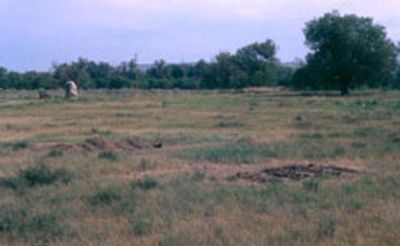
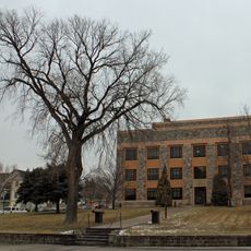
Fort Pierre Chouteau is an archaeological site and National Historic Landmark containing underground remains of a large trading post along the Missouri River. The marked location preserves foundation outlines and artifact layers that document decades of active commerce and occupation.

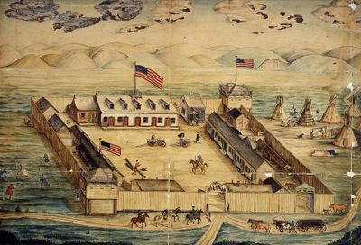
The American Fur Company built the fort in 1832 as a successor to Fort Tecumseh, making it the largest trading center on the upper Missouri. The site remained active for about 25 years before being abandoned in 1857.

The site drew Lakota Sioux and other tribes who came to exchange buffalo robes and furs for European goods. These trading relationships shaped the economic life and daily interactions across the entire region.

The site is clearly marked and can be visited without entry fees, with underground structures remaining visible from above. Learning about the archaeology beforehand helps visitors better understand what the preserved features reveal about the fort's past.

The fort processed around 17,000 buffalo robes per year at its peak, making it a central hub in the North American fur trade. This volume reveals the enormous economic importance of the trading operation across the entire region.

The community of curious travelers

AroundUs brings together thousands of curated places, local tips, and hidden gems, enriched daily by 60,000 contributors worldwide.

Start exploring
Location
GPS coordinates
44.38920,-100.39100
Latest update
December 14, 2025 12:26
Around this place
Lake Oahe
United States of America

Lake Oahe

6.9 km
South Dakota Governor's Residence
United States of America

South Dakota Governor's Residence

4.8 km
South Dakota State Capitol
United States of America

South Dakota State Capitol

4.3 km
Pierre Shale
Canada

Pierre Shale

1.8 km
Big Bend
United States of America

Big Bend

70.6 km
Verendrye Site
United States of America

Verendrye Site

3.9 km
Chicago and North Western Railroad Bridge
United States of America

Chicago and North Western Railroad Bridge

2.4 km
Hughes County Courthouse
United States of America

Hughes County Courthouse

3.9 km
I. W. Goodner House
United States of America

I. W. Goodner House

3.5 km
Peter Hansen House
United States of America

Peter Hansen House

4.7 km
Farr House
United States of America

Farr House

3.9 km
G.L. Stocker Blacksmith Shop
United States of America

G.L. Stocker Blacksmith Shop

77.3 km
Dr. William and Elizabeth Blackburn House
United States of America

Dr. William and Elizabeth Blackburn House

5.9 km
Pierre Masonic Lodge
United States of America

Pierre Masonic Lodge

28.2 km
Fort Pierre Congregational Church
United States of America

Fort Pierre Congregational Church

4.2 km
Freier Round Barn
United States of America

Freier Round Barn

49.2 km
Brink-Wegner House
United States of America

Brink-Wegner House

3.5 km
Sully County Courthouse
United States of America

Sully County Courthouse

43.7 km
Potter County Courthouse
United States of America

Potter County Courthouse

77.2 km
Karcher–Sahr House
United States of America

Karcher–Sahr House

4.2 km
L.E. Snyder House
United States of America

L.E. Snyder House

43.7 km
John E. and Ruth Hipple House
United States of America

John E. and Ruth Hipple House

4.1 km
Jefferson Davis Carr House
United States of America

Jefferson Davis Carr House

4 km
Murdo State Bank
United States of America

Murdo State Bank

61.5 km
Crawford–Pettyjohn House
United States of America

Crawford–Pettyjohn House

5.2 km
Horner–Hyde House
United States of America

Horner–Hyde House

3.9 km
Methodist Episcopal Church
United States of America

Methodist Episcopal Church

3.6 km
LaFramboise Island Nature Area
United States of America

LaFramboise Island Nature Area

5.7 km
Show the full map
« Fort Pierre Chouteau - Archaeological site and National Historic Landmark in Fort Pierre, United States » is provided by Around Us (aroundus.com). Images and texts are derived from Wikimedia project under a Creative Commons license. You are allowed to copy, distribute, and modify copies of this page, under the conditions set by the license, as long as this note is clearly visible.

Discover hidden gems everywhere you go!

From secret cafés to breathtaking viewpoints, skip the crowded tourist spots and find places that match your style. Our app makes it easy with voice search, smart filtering, route optimization, and insider tips from travelers worldwide. Download now for the complete mobile experience.

Around Us App Screenshot

A unique approach to discovering new places

Le Figaro

All the places worth exploring

France Info

A tailor-made excursion in just a few clicks

20 Minutes

Around Us
Travel Guide & Maps
Download

Send to your phone

QR Code
1

Open the camera app on your mobile.

2

Point at the QR code with your camera. A notification will appear.

3

Tap the notification to open the link.