Chest opened
+${chestReward.xp} XP
Explorer
NOUVEAU ×${chestReward.collectible.quantity}
tapez pour fermer
Chest locked

Open chests in the app

Around Us is built for your phone — chests unlock when you walk, explore and capture nearby places.

Enable Location

We need your location to show you interesting places around you

Discover nearby places

Find interesting locations and hidden gems around you

Precise directions

Get accurate directions and distances to places

Your location is never shared with other users. It's only used when you tap the location button.

Plattsburgh Air Force Base

Log in to your account

Start exploring — it's free

Trusted by 72,889 travelers worldwide

Continue with Google
Continue with Apple
or

We will send you a code to connect

By continuing, you accept our Terms and Conditions and our Privacy Policy

Check your inbox

We've sent a pincode in your inbox. Please enter the code below.

Plattsburgh Air Force Base
Discussion Reviews 1 Photos
26.1k Popularity

Plattsburgh Air Force Base, Military airport in Plattsburgh, United States

Plattsburgh Air Force Base was a military airport on the western shore of Lake Champlain with two runways and numerous support buildings. After its closure, the site became a civilian airport serving regional airlines and business aviation operations.

Military operations began at this location in 1814 during the War of 1812 as a defense point. The site became a Strategic Air Command facility during the Cold War and remained active until 1995.

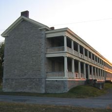
Museums inside former military buildings display aircraft, uniforms, and personal items from pilots who served here over the decades. These collections tell stories about aviation and the daily lives of service members stationed at the base.

The airport is located about 6 miles (10 kilometers) north of downtown Plattsburgh and is accessible by car from the main road. Visitors can explore the grounds and museums, and parking is available near the terminal and museum buildings.

Underground missile launch sites were constructed within a 50-mile (80-kilometer) radius of the base as part of Cold War nuclear deterrence. These hidden facilities stored and prepared intercontinental ballistic missiles for potential launch.

The community of curious travelers

AroundUs brings together thousands of curated places, local tips, and hidden gems, enriched daily by 60,000 contributors worldwide.

Start exploring
Location
Inception
1954
Elevation above the sea
71 m
GPS coordinates
44.65390,-73.46560
Latest update
December 18, 2025 11:41
Around this place
Ausable Chasm
United States of America

Ausable Chasm

13.9 km
Old Stone Barracks
United States of America

Old Stone Barracks

3.4 km
Bluff Point Light
United States of America

Bluff Point Light

4.3 km
AuSable Chasm Bridge
United States of America

AuSable Chasm Bridge

14.4 km
Cumberland Head Light
United States of America

Cumberland Head Light

7.6 km
Hawkins Hall
United States of America

Hawkins Hall

4.8 km
Strand Theate
United States of America

Strand Theate

4.9 km
St. John the Baptist Roman Catholic Church
United States of America

St. John the Baptist Roman Catholic Church

4.7 km
Plattsburgh Bay
United States of America

Plattsburgh Bay

8.3 km
Clinton County Courthouse Complex
United States of America

Clinton County Courthouse Complex

5.1 km
Kent-Delord House
United States of America

Kent-Delord House

5.6 km
City Hall
United States of America

City Hall

5.1 km
United States Oval Historic District
United States of America

United States Oval Historic District

3.9 km
Carpenter's Flats Bridge
United States of America

Carpenter's Flats Bridge

10.7 km
W. W. Hartwell House & Dependencies
United States of America

W. W. Hartwell House & Dependencies

4.8 km
Charles C. Platt Homestead
United States of America

Charles C. Platt Homestead

6.1 km
D'Youville Academy
United States of America

D'Youville Academy

5.1 km
Peru Community Church
United States of America

Peru Community Church

9.7 km
House at 56 Cornelia Street
United States of America

House at 56 Cornelia Street

5.2 km
Court Street Historic District
United States of America

Court Street Historic District

4.9 km
William Bailey House
United States of America

William Bailey House

5.2 km
The Point Historic District
United States of America

The Point Historic District

4.9 km
Brinkerhoff Street Historic District
United States of America

Brinkerhoff Street Historic District

4.8 km
Paul Marshall House
United States of America

Paul Marshall House

5.2 km
S. F. Vilas Home for Aged & Infirmed Ladies
United States of America

S. F. Vilas Home for Aged & Infirmed Ladies

5 km
W. G. Wilcox House
United States of America

W. G. Wilcox House

5.6 km
Gordon-Center House
United States of America

Gordon-Center House

10.8 km
Winslow-Turner Carriage House
United States of America

Winslow-Turner Carriage House

5.1 km
Show the full map
Reviews
Share your experience

No review yet

Discussions
Start a discussion...

No discussion yet

« Plattsburgh Air Force Base - Military airport in Plattsburgh, United States » is provided by Around Us (aroundus.com). Images and texts are derived from Wikimedia project under a Creative Commons license. You are allowed to copy, distribute, and modify copies of this page, under the conditions set by the license, as long as this note is clearly visible.

Discover hidden gems everywhere you go!

From secret cafés to breathtaking viewpoints, skip the crowded tourist spots and find places that match your style. Our app makes it easy with voice search, smart filtering, route optimization, and insider tips from travelers worldwide. Download now for the complete mobile experience.

Around Us App Screenshot

A unique approach to discovering new places

Le Figaro

All the places worth exploring

France Info

A tailor-made excursion in just a few clicks

20 Minutes

Around Us
Travel Guide & Maps
Download

Send to your phone

QR Code
1

Open the camera app on your mobile.

2

Point at the QR code with your camera. A notification will appear.

3

Tap the notification to open the link.