AuSable Chasm Bridge

Log in to your account

AroundUs is a community-driven map of interesting places, built by curious explorers like you. It grows with every review, story, and photo you share.
Connect to save your favorite spots, contribute locations, and create personalized routes.
Continue with Google
Continue with Apple
Continue with X
Continue with Facebook
Continue with email
By continuing, you accept our Terms and Conditions and our Privacy Policy
Create an account
Add to collection
Map
Suggest a change
Share

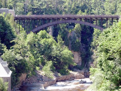
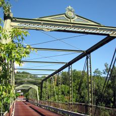
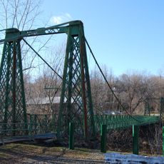
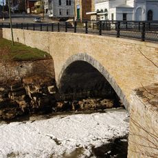
AuSable Chasm Bridge, Steel arch bridge over Ausable River in New York, United States.

The AuSable Chasm Bridge is a steel arch bridge spanning the AuSable River and connecting two counties in upstate New York. The structure uses a single large arch as its main span, supported by concrete approach ramps on both sides to carry traffic across the river at a height that allows boats to pass below.

Construction took place in the early 1930s when engineer C.C. MacCloskey and builder Burr M. Stark created this new structure to replace an earlier railroad crossing at the site. This period marked the shift from rail to automobile transportation as the primary way people moved through the region.

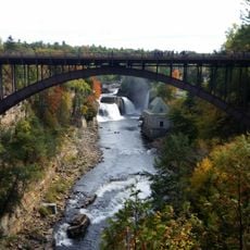
The bridge connects communities on both sides of the river and serves as a gateway to exploring the dramatic AuSable Chasm area. Its role in the valley reflects how local infrastructure evolved to serve both daily travel and visitors seeking to experience this natural landscape.

The bridge carries daily traffic on US Route 9 with a standard roadway width and is in good condition for regular through traffic. Visitors exploring the AuSable Chasm area use this crossing and can view the structure and surrounding canyon from nearby overlooks.

The bridge earned recognition on the National Register of Historic Places and is part of a larger collection documenting bridges across the AuSable River Valley. Its design combines stone-faced approach ramps with the steel arch, reflecting engineering practices that treated functional structures as visual elements in the landscape.

Location: New York

GPS coordinates: 44.52472,-73.46333

Latest update: December 13, 2025 12:40

Photos
Around this place
Ausable Chasm
United States of America

Ausable Chasm

525 m
Rock Dunder
United States of America

Rock Dunder

18.3 km
Ethan Allen Homestead
United States of America

Ethan Allen Homestead

18.6 km
Old Stone Barracks
United States of America

Old Stone Barracks

17.4 km
Bluff Point Light
United States of America

Bluff Point Light

11.3 km
Juniper Island Light
United States of America

Juniper Island Light

17 km
Double-Span Metal Pratt Truss Bridge
United States of America

Double-Span Metal Pratt Truss Bridge

3.2 km
St. John the Baptist Roman Catholic Church
United States of America

St. John the Baptist Roman Catholic Church

19 km
Swing Bridge
United States of America

Swing Bridge

2.8 km
Ligonier Point Historic District
United States of America

Ligonier Point Historic District

14 km
Elkanah Watson House
United States of America

Elkanah Watson House

4.6 km
Poke-O-Moonshine Mountain Fire Observation Station
United States of America

Poke-O-Moonshine Mountain Fire Observation Station

14.3 km
Adsit Log Cabin
United States of America

Adsit Log Cabin

13.4 km
The Willsboro School
United States of America

The Willsboro School

18.7 km
Stone Arch Bridge
United States of America

Stone Arch Bridge

2.6 km
Willsboro Congregational Church
United States of America

Willsboro Congregational Church

18.8 km
Edgewater Farm
United States of America

Edgewater Farm

15.1 km
United States Oval Historic District
United States of America

United States Oval Historic District

18 km
Carpenter's Flats Bridge
United States of America

Carpenter's Flats Bridge

4 km
Old State Road Bridge
United States of America

Old State Road Bridge

272 m
Peru Community Church
United States of America

Peru Community Church

7.9 km
Keeseville Historic District
United States of America

Keeseville Historic District

2.7 km
Rembrandt Hall
United States of America

Rembrandt Hall

2.8 km
Tomlinson House
United States of America

Tomlinson House

2.7 km
The Point Historic District
United States of America

The Point Historic District

19.1 km
Miller Homestead
United States of America

Miller Homestead

7.8 km
Howard Mortuary Chapel
United States of America

Howard Mortuary Chapel

18.9 km
North Star Underground Railroad Museum
United States of America

North Star Underground Railroad Museum

159 m
Show the full map
Reviews

Visited this place? Tap the stars to rate it and share your experience / photos with the community! Try now! You can cancel it anytime.

« AuSable Chasm Bridge - Steel arch bridge over Ausable River in New York, United States » is provided by Around Us (aroundus.com). Images and texts are derived from Wikimedia project under a Creative Commons license. You are allowed to copy, distribute, and modify copies of this page, under the conditions set by the license, as long as this note is clearly visible.

Discover hidden gems everywhere you go!

From secret cafés to breathtaking viewpoints, skip the crowded tourist spots and find places that match your style. Our app makes it easy with voice search, smart filtering, route optimization, and insider tips from travelers worldwide. Download now for the complete mobile experience.

Around Us App Screenshot

A unique approach to discovering new places

Le Figaro

All the places worth exploring

France Info

A tailor-made excursion in just a few clicks

20 Minutes