Enable Location

We need your location to show you interesting places around you

Discover nearby places

Find interesting locations and hidden gems around you

Precise directions

Get accurate directions and distances to places

Your location is never shared with other users. It's only used when you tap the location button.

Poke-O-Moonshine Mountain Fire Observation Station

Log in to your account

Join the adventure

Create your free account and start exploring (like 60k+ others)

We will send you a code to connect

or
Continue with Google
Continue with Apple
By continuing, you accept our Terms and Conditions and our Privacy Policy

Check your inbox

We've sent a pincode in your inbox. Please enter the code below.

Poke-O-Moonshine Mountain Fire Observation Station

Poke-O-Moonshine Mountain Fire Observation Station, Fire lookout station in Essex County, United States.

Description

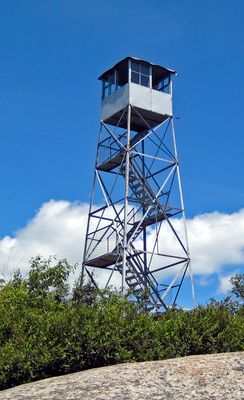
Poke-O-Moonshine Mountain Fire Observation Station is a steel fire lookout tower perched on a 2,165 feet (660 m) peak in Essex County. The tower provides sweeping views across the Adirondack region and toward Lake Champlain on clear days.

History

The tower was built in 1917 by the Aermotor Windmill Company and served as a key fire monitoring post during the early years of organized forest management. Its role in New York's forest conservation efforts led to its listing on the National Register of Historic Places in 2001.

Culture

The station represents the evolution of forest conservation practices in New York State, leading to its inclusion in the National Register of Historic Places in 2001.

Practical

Two trails ascend to the summit: the shorter Ranger's Trail offers a steeper climb, while the Observer's Trail provides a more gradual route, both beginning near Route 9. Allow several hours for the hike, as conditions and difficulty can change depending on the season and weather.

Did you know?

The mountain's name comes from Algonquin words: 'pohqui' means broken and 'moosie' means smooth, which early settlers transformed into 'Poke-O-Moonshine'. This naming history reflects how indigenous language was adapted and reshaped through European pronunciation and spelling.

Location
Inception
1917
GPS coordinates
44.40171,-73.51306
Latest update
December 14, 2025 18:47

AroundUs brings together thousands of curated places, local tips, and hidden gems, enriched daily by 60,000 contributors worldwide. Discover all places nearby (Essex County).

Around this place
Ausable Chasm
United States of America

Ausable Chasm

14.8 km
Jay Bridge
United States of America

Jay Bridge

17.2 km
AuSable Chasm Bridge
United States of America

AuSable Chasm Bridge

14.3 km
Juniper Island Light
United States of America

Juniper Island Light

19.6 km
Double-Span Metal Pratt Truss Bridge
United States of America

Double-Span Metal Pratt Truss Bridge

11.2 km
Swing Bridge
United States of America

Swing Bridge

11.6 km
Ligonier Point Historic District
United States of America

Ligonier Point Historic District

11.1 km
Elkanah Watson House
United States of America

Elkanah Watson House

16.1 km
Adsit Log Cabin
United States of America

Adsit Log Cabin

11.1 km
The Willsboro School
United States of America

The Willsboro School

10.6 km
Stone Arch Bridge
United States of America

Stone Arch Bridge

11.8 km
Octagonal Schoolhouse
United States of America

Octagonal Schoolhouse

14 km
Willsboro Congregational Church
United States of America

Willsboro Congregational Church

10.4 km
Edgewater Farm
United States of America

Edgewater Farm

10.2 km
Foothills Baptist Church
United States of America

Foothills Baptist Church

14.2 km
Carpenter's Flats Bridge
United States of America

Carpenter's Flats Bridge

18.2 km
Old State Road Bridge
United States of America

Old State Road Bridge

14.2 km
Peru Community Church
United States of America

Peru Community Church

19.7 km
Keeseville Historic District
United States of America

Keeseville Historic District

11.7 km
Rembrandt Hall
United States of America

Rembrandt Hall

11.5 km
Tomlinson House
United States of America

Tomlinson House

11.6 km
Palmer Brook Bridge
United States of America

Palmer Brook Bridge

13.7 km
Essex Village Historic District
United States of America

Essex Village Historic District

16.2 km
Essex County Home and Farm
United States of America

Essex County Home and Farm

18.1 km
Sheldon-Owens Farm
United States of America

Sheldon-Owens Farm

12.7 km
Abraham Aiken House
United States of America

Abraham Aiken House

13.6 km
Miller Homestead
United States of America

Miller Homestead

14.1 km
North Star Underground Railroad Museum
United States of America

North Star Underground Railroad Museum

14.4 km
Show the full map
« Poke-O-Moonshine Mountain Fire Observation Station - Fire lookout station in Essex County, United States » is provided by Around Us (aroundus.com). Images and texts are derived from Wikimedia project under a Creative Commons license. You are allowed to copy, distribute, and modify copies of this page, under the conditions set by the license, as long as this note is clearly visible.

Discover hidden gems everywhere you go!

From secret cafés to breathtaking viewpoints, skip the crowded tourist spots and find places that match your style. Our app makes it easy with voice search, smart filtering, route optimization, and insider tips from travelers worldwide. Download now for the complete mobile experience.

Around Us App Screenshot

A unique approach to discovering new places

Le Figaro

All the places worth exploring

France Info

A tailor-made excursion in just a few clicks

20 Minutes

Around Us
Travel Guide & Maps
Download

Send to your phone

QR Code
1

Open the camera app on your mobile.

2

Point at the QR code with your camera. A notification will appear.

3

Tap the notification to open the link.