Enable Location

We need your location to show you interesting places around you

Discover nearby places

Find interesting locations and hidden gems around you

Precise directions

Get accurate directions and distances to places

Your location is never shared with other users. It's only used when you tap the location button.

Jay Bridge

Log in to your account

Start exploring — it's free

Trusted by 61,867 travelers worldwide

Continue with Google
Continue with Apple
or

We will send you a code to connect

By continuing, you accept our Terms and Conditions and our Privacy Policy

Check your inbox

We've sent a pincode in your inbox. Please enter the code below.

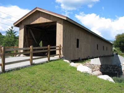
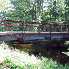
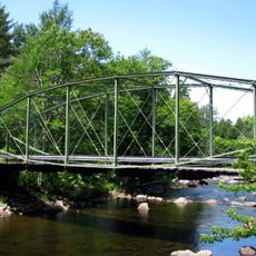
Jay Bridge, Covered bridge in Jay, New York, US.

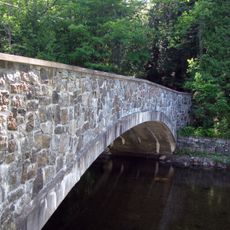
Jay Bridge is a covered wooden bridge that spans the east branch of the Ausable River using a Howe truss framework. The structure combines timber beams with metal tension rods to carry foot and bicycle traffic across the water.

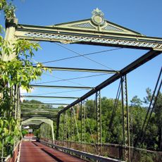
The bridge was reconstructed after a devastating flood in 1856 using the Howe truss design, a method that soon spread throughout New England. This engineering approach demonstrated how traditional materials could be strengthened with metal components.

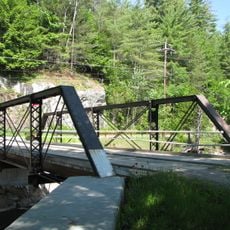
The bridge represents a shift in American engineering practices, combining traditional wooden construction methods with metal components for enhanced structural performance.

The bridge is open to foot and bicycle traffic at no charge and can be crossed during daylight hours. The pathway is narrow with wooden surfaces that become slippery when wet, so careful footing is important.

Metal fasteners on the vertical posts allow for fine adjustments to the structural tension, showing an early use of adjustable engineering. This system let the bridge adapt to temperature shifts and changing loads over time.

The community of curious travelers

AroundUs brings together thousands of curated places, local tips, and hidden gems, enriched daily by 60,000 contributors worldwide.

Start exploring
Location
Jay
GPS coordinates
44.37310,-73.72500
Latest update
December 12, 2025 17:43
Around this place
Whiteface Mountain
United States of America

Whiteface Mountain

14.2 km
John Brown Farm State Historic Site
United States of America

John Brown Farm State Historic Site

23.8 km
Lake Placid
United States of America

Lake Placid

22.4 km
Giant Mountain
United States of America

Giant Mountain

23.6 km
Cascade Mountain
United States of America

Cascade Mountain

20.3 km
Lake Placid Equestrian Stadium
United States of America

Lake Placid Equestrian Stadium

22.9 km
Porter Mountain
United States of America

Porter Mountain

20.6 km
Lake Placid Winter Olympic Museum
United States of America

Lake Placid Winter Olympic Museum

22.9 km
Esther Mountain
United States of America

Esther Mountain

13.2 km
Pitchoff Mountain
United States of America

Pitchoff Mountain

19.4 km
Double-Span Metal Pratt Truss Bridge
United States of America

Double-Span Metal Pratt Truss Bridge

23.7 km
Hurricane Mountain Fire Observation Station
United States of America

Hurricane Mountain Fire Observation Station

15.4 km
Poke-O-Moonshine Mountain Fire Observation Station
United States of America

Poke-O-Moonshine Mountain Fire Observation Station

17.2 km
Ranney Bridge
United States of America

Ranney Bridge

21.8 km
Hand-Hale Historic District
United States of America

Hand-Hale Historic District

20.7 km
Walton Bridge
United States of America

Walton Bridge

15.4 km
Hubbard Hall
United States of America

Hubbard Hall

20.5 km
Lake Placid Olympic Museum
United States of America

Lake Placid Olympic Museum

23 km
Beer's Bridge
United States of America

Beer's Bridge

23.1 km
Keene Valley Library
United States of America

Keene Valley Library

20.9 km
Palmer Brook Bridge
United States of America

Palmer Brook Bridge

8.8 km
Notman Bridge
United States of America

Notman Bridge

20.8 km
Wells Memorial Library
United States of America

Wells Memorial Library

5.5 km
Keith and Branch Ford Motors Factory and Showroom
United States of America

Keith and Branch Ford Motors Factory and Showroom

5.9 km
Miller Homestead
United States of America

Miller Homestead

21.2 km
Santa's Workshop
United States of America

Santa's Workshop

10.4 km
High Falls Gorge
United States of America

High Falls Gorge

12.2 km
Hopkins Cottage
United States of America

Hopkins Cottage

8.5 km
Show the full map
« Jay Bridge - Covered bridge in Jay, New York, US » is provided by Around Us (aroundus.com). Images and texts are derived from Wikimedia project under a Creative Commons license. You are allowed to copy, distribute, and modify copies of this page, under the conditions set by the license, as long as this note is clearly visible.

Discover hidden gems everywhere you go!

From secret cafés to breathtaking viewpoints, skip the crowded tourist spots and find places that match your style. Our app makes it easy with voice search, smart filtering, route optimization, and insider tips from travelers worldwide. Download now for the complete mobile experience.

Around Us App Screenshot

A unique approach to discovering new places

Le Figaro

All the places worth exploring

France Info

A tailor-made excursion in just a few clicks

20 Minutes

Around Us
Travel Guide & Maps
Download

Send to your phone

QR Code
1

Open the camera app on your mobile.

2

Point at the QR code with your camera. A notification will appear.

3

Tap the notification to open the link.