Enable Location

We need your location to show you interesting places around you

Discover nearby places

Find interesting locations and hidden gems around you

Precise directions

Get accurate directions and distances to places

Your location is never shared with other users. It's only used when you tap the location button.

Pratt Mountain

Log in to your account

Start exploring — it's free

Trusted by 62,127 travelers worldwide

Continue with Google
Continue with Apple
or

We will send you a code to connect

By continuing, you accept our Terms and Conditions and our Privacy Policy

Check your inbox

We've sent a pincode in your inbox. Please enter the code below.

Pratt Mountain

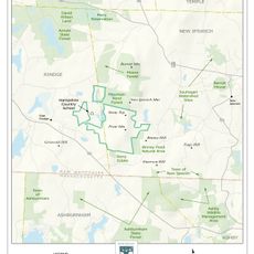
Pratt Mountain, Mountain summit in New Ipswich, New Hampshire.

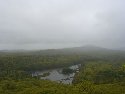
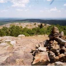
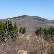
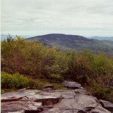
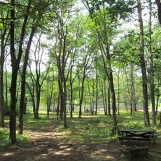
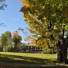
Pratt Mountain is a summit in New Ipswich that rises to approximately 1,826 feet with rocky ledges and several viewpoints throughout the area. These overlooks provide views toward Mount Monadnock and the forested landscape stretching across New Hampshire's southern region.

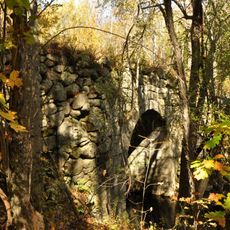
The mountain forms part of the Wapack Range, a geological formation originating approximately 400 million years ago. Its rocky composition developed through ancient geological processes that shaped the metamorphic stone structures visible today.

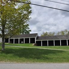
The 22-mile Wapack Trail crosses Pratt Mountain, connecting several peaks and serving local hiking communities throughout New Hampshire's southern region.

The hiking trail from Binney Hill Road stretches about 5 miles and passes through thick woods and rocky ground, marked with yellow triangular blazes. Good footwear and caution are needed on steep and rocky sections throughout the hike.

This mountain sits at a location where water flows into two separate river systems: eastward to the Souhegan River and westward to the Millers River. This watershed divide makes it a noteworthy spot for understanding how the region's water systems branch off in different directions.

The community of curious travelers

AroundUs brings together thousands of curated places, local tips, and hidden gems, enriched daily by 60,000 contributors worldwide.

Start exploring
Location
GPS coordinates
42.73299,-71.91913
Latest update
December 14, 2025 13:04
Around this place
Mount Watatic
United States of America

Mount Watatic

4.6 km
Pack Monadnock
United States of America

Pack Monadnock

14.7 km
Wapack Trail
United States of America

Wapack Trail

9.4 km
Pearl Hill State Park
United States of America

Pearl Hill State Park

15.1 km
Miller State Park
United States of America

Miller State Park

13.8 km
United States of America

Temple Mountain

12.3 km
Barrett House
United States of America

Barrett House

5.6 km
Andy's Summer Playhouse
United States of America

Andy's Summer Playhouse

16 km
Cambridge Grant Historic District
United States of America

Cambridge Grant Historic District

10.9 km
Peterborough Town House
United States of America

Peterborough Town House

16.3 km
All Saints Church
United States of America

All Saints Church

16.6 km
New Ipswich Town Hall
United States of America

New Ipswich Town Hall

5.5 km
Ashburnham Center Historic District
United States of America

Ashburnham Center Historic District

10.9 km
Temple Town Hall
United States of America

Temple Town Hall

11.1 km
Second Rindge Meetinghouse, Horsesheds and Cemetery
United States of America

Second Rindge Meetinghouse, Horsesheds and Cemetery

7.7 km
County Farm Bridge
United States of America

County Farm Bridge

16.1 km
Wapack Wilderness
United States of America

Wapack Wilderness

1.2 km
Old Centre Historic District
United States of America

Old Centre Historic District

12.6 km
Oliver Whiting Homestead
United States of America

Oliver Whiting Homestead

15.7 km
Jaffrey Center Historic District
United States of America

Jaffrey Center Historic District

15.4 km
East Jaffrey Historic District
United States of America

East Jaffrey Historic District

12.6 km
New Ipswich Center Village Historic District
United States of America

New Ipswich Center Village Historic District

5.6 km
Jaffrey Mills
United States of America

Jaffrey Mills

12.5 km
Winchendon Village Historic District
United States of America

Winchendon Village Historic District

12.1 km
Ashby Free Public Library
United States of America

Ashby Free Public Library

10.2 km
Lake Monomonac
United States of America

Lake Monomonac

6.5 km
Livermore Bridge
United States of America

Livermore Bridge

15.7 km
Great Trestle
United States of America

Great Trestle

10.4 km
Show the full map
« Pratt Mountain - Mountain summit in New Ipswich, New Hampshire » is provided by Around Us (aroundus.com). Images and texts are derived from Wikimedia project under a Creative Commons license. You are allowed to copy, distribute, and modify copies of this page, under the conditions set by the license, as long as this note is clearly visible.

Discover hidden gems everywhere you go!

From secret cafés to breathtaking viewpoints, skip the crowded tourist spots and find places that match your style. Our app makes it easy with voice search, smart filtering, route optimization, and insider tips from travelers worldwide. Download now for the complete mobile experience.

Around Us App Screenshot

A unique approach to discovering new places

Le Figaro

All the places worth exploring

France Info

A tailor-made excursion in just a few clicks

20 Minutes

Around Us
Travel Guide & Maps
Download

Send to your phone

QR Code
1

Open the camera app on your mobile.

2

Point at the QR code with your camera. A notification will appear.

3

Tap the notification to open the link.