Enable Location

We need your location to show you interesting places around you

Discover nearby places

Find interesting locations and hidden gems around you

Precise directions

Get accurate directions and distances to places

Your location is never shared with other users. It's only used when you tap the location button.

Riverdale Road Covered Bridge

Log in to your account

Start exploring — it's free

Trusted by 62,846 travelers worldwide

Continue with Google
Continue with Apple
or

We will send you a code to connect

By continuing, you accept our Terms and Conditions and our Privacy Policy

Check your inbox

We've sent a pincode in your inbox. Please enter the code below.

Riverdale Road Covered Bridge

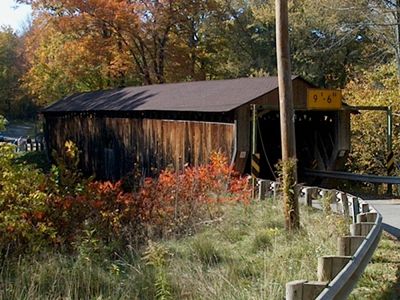
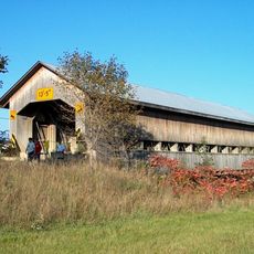
Riverdale Road Covered Bridge, Covered bridge in Ashtabula County, United States.

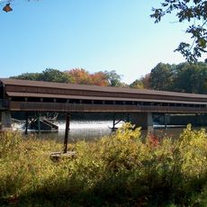
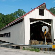
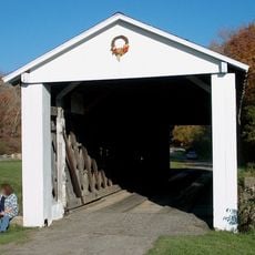
Riverdale Road Covered Bridge is a wooden road crossing over the Ashtabula River built with traditional truss methods. The structure spans about 115 feet (35 meters) and shows the typical construction approach of these historical spans.

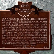
The structure was built in 1874 and served the local community as a vital transportation link for many decades. A substantial overhaul in the 1980s extended its lifespan while keeping its original character intact.

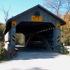
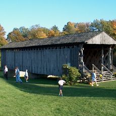
This bridge is part of a dense collection of such structures that defines the region's heritage. Local residents connect these spans to their area's identity, and visitors today encounter them as symbols of how the community values its past.

The structure can be driven across and sits on one of several routes through the area connecting multiple such bridges. The best visiting period is spring through autumn, when road conditions and visibility are most comfortable.

During restoration work, modern wood girders were installed to stabilize the old structure while its Victorian appearance was preserved. This blend of old and new is rarely noticed, but was essential to keeping the bridge safe for travel.

The community of curious travelers

AroundUs brings together thousands of curated places, local tips, and hidden gems, enriched daily by 60,000 contributors worldwide.

Start exploring
Location
GPS coordinates
41.67330,-80.87190
Latest update
December 14, 2025 13:03
Around this place
Madison Seminary
United States of America

Madison Seminary

19.5 km
Smolen–Gulf Bridge
United States of America

Smolen–Gulf Bridge

22.3 km
Geneva State Park
United States of America

Geneva State Park

21.8 km
Harpersfield Covered Bridge
United States of America

Harpersfield Covered Bridge

11 km
West Liberty Covered Bridge
United States of America

West Liberty Covered Bridge

15.4 km
Windsor Mills Covered Bridge
United States of America

Windsor Mills Covered Bridge

17.4 km
Geauga County Courthouse
United States of America

Geauga County Courthouse

23.2 km
Caine Road Covered Bridge
United States of America

Caine Road Covered Bridge

23.5 km
Ashtabula County Courthouse Group
United States of America

Ashtabula County Courthouse Group

11.2 km
Shandy Hall
United States of America

Shandy Hall

15.2 km
Joshua Reed Giddings Law Office
United States of America

Joshua Reed Giddings Law Office

11.4 km
Mechanicsville Road Covered Bridge
United States of America

Mechanicsville Road Covered Bridge

9.3 km
Doyle Road Covered Bridge
United States of America

Doyle Road Covered Bridge

12 km
Giddings Road Covered Bridge
United States of America

Giddings Road Covered Bridge

15.4 km
Netcher Road Covered Bridge
United States of America

Netcher Road Covered Bridge

13.7 km
South Denmark Road Covered Bridge
United States of America

South Denmark Road Covered Bridge

15.9 km
Graham Road Covered Bridge
United States of America

Graham Road Covered Bridge

24.3 km
Addison Kimball House
United States of America

Addison Kimball House

18.8 km
Riverview Covered Bridge
United States of America

Riverview Covered Bridge

22.2 km
Windsor Mills Christ Church Episcopal
United States of America

Windsor Mills Christ Church Episcopal

17 km
Eliphalet Austin House
United States of America

Eliphalet Austin House

11.4 km
Griggs Grange No. 1467
United States of America

Griggs Grange No. 1467

18.4 km
South Leroy Meetinghouse
United States of America

South Leroy Meetinghouse

22.9 km
L. W. Peck House
United States of America

L. W. Peck House

5.1 km
Karl A. Staley House
United States of America

Karl A. Staley House

23.6 km
Benjamin F. Wade House
United States of America

Benjamin F. Wade House

11.2 km
Ashtabula Train Disaster December 29, 1876
United States of America

Ashtabula Train Disaster December 29, 1876

23.8 km
Harpersfield Covered Bridge
United States of America

Harpersfield Covered Bridge

11 km
Show the full map
« Riverdale Road Covered Bridge - Covered bridge in Ashtabula County, United States » is provided by Around Us (aroundus.com). Images and texts are derived from Wikimedia project under a Creative Commons license. You are allowed to copy, distribute, and modify copies of this page, under the conditions set by the license, as long as this note is clearly visible.

Discover hidden gems everywhere you go!

From secret cafés to breathtaking viewpoints, skip the crowded tourist spots and find places that match your style. Our app makes it easy with voice search, smart filtering, route optimization, and insider tips from travelers worldwide. Download now for the complete mobile experience.

Around Us App Screenshot

A unique approach to discovering new places

Le Figaro

All the places worth exploring

France Info

A tailor-made excursion in just a few clicks

20 Minutes

Around Us
Travel Guide & Maps
Download

Send to your phone

QR Code
1

Open the camera app on your mobile.

2

Point at the QR code with your camera. A notification will appear.

3

Tap the notification to open the link.