Caine Road Covered Bridge

Log in to your account

AroundUs is a community-driven map of interesting places, built by curious explorers like you. It grows with every review, story, and photo you share.
Connect to save your favorite spots, contribute locations, and create personalized routes.
Continue with Google
Continue with Apple
Continue with X
Continue with Facebook
Continue with email
By continuing, you accept our Terms and Conditions and our Privacy Policy
Create an account
Add to collection
Map
Suggest a change
Share

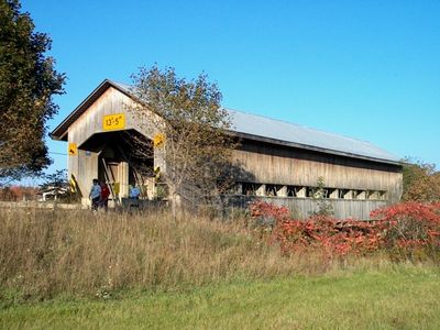
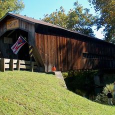
Caine Road Covered Bridge, Covered bridge in Pierpont Township, Ashtabula County, Ohio, United States

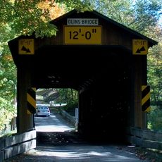
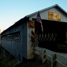
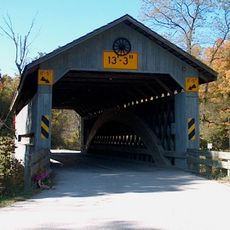
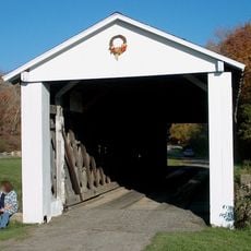
Caine Road Covered Bridge is a wooden structure spanning the West Branch of the Ashtabula River using a single-span Pratt truss frame. The bridge remains passable for vehicle traffic with a clearance height of about 13 feet 5 inches.

Built in 1986 by John Smolen Jr., the bridge was created as part of Ashtabula County's 175th anniversary celebration. It was named to honor the Caine family, early settlers in the Pierpont area.

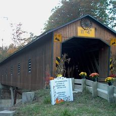
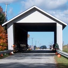
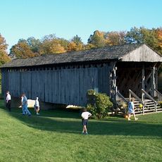
The bridge is one of about 19 covered spans in Ashtabula County, showing how this region keeps traditional wooden bridge construction alive. You can see how these structures remain active and useful in the local landscape today.

The bridge is located roughly 13 miles east-northeast of Jefferson and is open to vehicle traffic. Plan your visit with the rural setting and road conditions in mind.

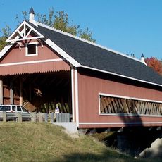
This bridge was assigned the official designation WGCB 35-04-61 and is among the newest additions to Ohio's collection of over 125 wooden covered bridges. It demonstrates that traditional bridge building techniques are still being applied in recent years.

Location: Ohio

GPS coordinates: 41.76470,-80.61640

Latest update: December 14, 2025 14:21

Photos
Around this place
Smolen–Gulf Bridge
United States of America

Smolen–Gulf Bridge

15.8 km
Pymatuning State Park
United States of America

Pymatuning State Park

18.9 km
Ashtabula lift bridge
United States of America

Ashtabula lift bridge

21.3 km
Benetka Road Covered Bridge
United States of America

Benetka Road Covered Bridge

11.1 km
Ashtabula Harbor Light
United States of America

Ashtabula Harbor Light

22.7 km
State Road Covered Bridge
United States of America

State Road Covered Bridge

13.6 km
Mother of Sorrows Church
United States of America

Mother of Sorrows Church

21.3 km
Middle Road Covered Bridge
United States of America

Middle Road Covered Bridge

16.3 km
Ashtabula County Courthouse Group
United States of America

Ashtabula County Courthouse Group

13.1 km
Olin's Covered Bridge
United States of America

Olin's Covered Bridge

13.9 km
Joshua Reed Giddings Law Office
United States of America

Joshua Reed Giddings Law Office

13 km
Root Road Covered Bridge
United States of America

Root Road Covered Bridge

7.6 km
Ashtabula Harbour Commercial District
United States of America

Ashtabula Harbour Commercial District

21.4 km
Creek Road Covered Bridge
United States of America

Creek Road Covered Bridge

17.3 km
Doyle Road Covered Bridge
United States of America

Doyle Road Covered Bridge

14.4 km
David Cummins Octagon House
United States of America

David Cummins Octagon House

20.2 km
Giddings Road Covered Bridge
United States of America

Giddings Road Covered Bridge

9.6 km
Netcher Road Covered Bridge
United States of America

Netcher Road Covered Bridge

10.1 km
South Denmark Road Covered Bridge
United States of America

South Denmark Road Covered Bridge

8.1 km
Graham Road Covered Bridge
United States of America

Graham Road Covered Bridge

1.9 km
Harrington Covered Bridge
United States of America

Harrington Covered Bridge

19.4 km
Riverview Covered Bridge
United States of America

Riverview Covered Bridge

15.8 km
Eliphalet Austin House
United States of America

Eliphalet Austin House

19.9 km
Griggs Grange No. 1467
United States of America

Griggs Grange No. 1467

8.5 km
L. W. Peck House
United States of America

L. W. Peck House

19.9 km
Ashtabula Maritime & Surface Transportation Museum
United States of America

Ashtabula Maritime & Surface Transportation Museum

21.5 km
Benjamin F. Wade House
United States of America

Benjamin F. Wade House

13 km
Ashtabula Train Disaster December 29, 1876
United States of America

Ashtabula Train Disaster December 29, 1876

19.5 km
Show the full map
Reviews

Visited this place? Tap the stars to rate it and share your experience / photos with the community! Try now! You can cancel it anytime.

« Caine Road Covered Bridge - Covered bridge in Pierpont Township, Ashtabula County, Ohio, United States » is provided by Around Us (aroundus.com). Images and texts are derived from Wikimedia project under a Creative Commons license. You are allowed to copy, distribute, and modify copies of this page, under the conditions set by the license, as long as this note is clearly visible.

Discover hidden gems everywhere you go!

From secret cafés to breathtaking viewpoints, skip the crowded tourist spots and find places that match your style. Our app makes it easy with voice search, smart filtering, route optimization, and insider tips from travelers worldwide. Download now for the complete mobile experience.

Around Us App Screenshot

A unique approach to discovering new places

Le Figaro

All the places worth exploring

France Info

A tailor-made excursion in just a few clicks

20 Minutes