Enable Location

We need your location to show you interesting places around you

Discover nearby places

Find interesting locations and hidden gems around you

Precise directions

Get accurate directions and distances to places

Your location is never shared with other users. It's only used when you tap the location button.

Ashtabula Harbor Light

Log in to your account

Start exploring — it's free

Trusted by 62,856 travelers worldwide

Continue with Google
Continue with Apple
or

We will send you a code to connect

By continuing, you accept our Terms and Conditions and our Privacy Policy

Check your inbox

We've sent a pincode in your inbox. Please enter the code below.

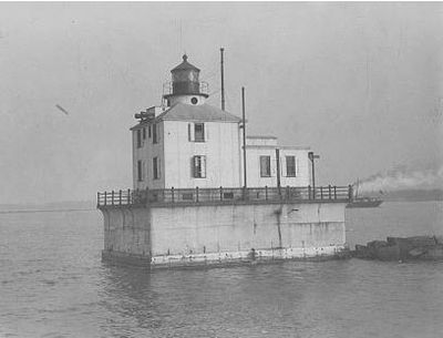
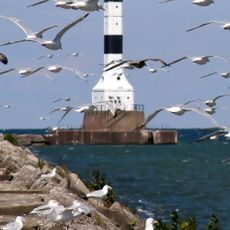
Ashtabula Harbor Light, Lighthouse on Lake Erie in Ashtabula County, United States

Ashtabula Harbor Light is a steel and iron plate lighthouse with a cylindrical tower and an adjoining rectangular house building at its base. The entire structure stands about 40 feet (12 meters) tall on the shore of Lake Erie.

The original wooden tower built in 1836 was replaced by a clapboard structure before the current iron construction was built in 1905 following harbor improvements. These changes show how the port evolved and how navigation aids were upgraded over time.

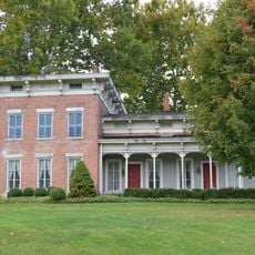
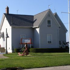
The former keeper's house, now a museum, shows how lighthouse workers lived and managed daily operations by the water. Exhibits inside reveal the role this light played in guiding ships and the lives of those who tended it.

Access to the lighthouse requires water transportation and uses a floating dock that was installed in 2008 with grant funding. Weather conditions and water levels affect whether visitors can safely reach the structure.

During a severe ice storm in 1928, lighthouse keepers had to dig a tunnel through thick ice to escape from the completely frozen structure. This dramatic event shows the extreme conditions workers faced in keeping the light operational.

The community of curious travelers

AroundUs brings together thousands of curated places, local tips, and hidden gems, enriched daily by 60,000 contributors worldwide.

Start exploring
Location
Height
12 m
GPS coordinates
41.91860,-80.79590
Latest update
December 14, 2025 13:03
Around this place
Smolen–Gulf Bridge
United States of America

Smolen–Gulf Bridge

7.6 km
Geneva State Park
United States of America

Geneva State Park

16.3 km
Ashtabula lift bridge
United States of America

Ashtabula lift bridge

2 km
West Liberty Covered Bridge
United States of America

West Liberty Covered Bridge

18.4 km
Benetka Road Covered Bridge
United States of America

Benetka Road Covered Bridge

11.8 km
State Road Covered Bridge
United States of America

State Road Covered Bridge

15 km
Mother of Sorrows Church
United States of America

Mother of Sorrows Church

2.6 km
Middle Road Covered Bridge
United States of America

Middle Road Covered Bridge

20.7 km
Ashtabula County Courthouse Group
United States of America

Ashtabula County Courthouse Group

20.2 km
Shandy Hall
United States of America

Shandy Hall

21.7 km
Olin's Covered Bridge
United States of America

Olin's Covered Bridge

8.8 km
Joshua Reed Giddings Law Office
United States of America

Joshua Reed Giddings Law Office

19.9 km
Root Road Covered Bridge
United States of America

Root Road Covered Bridge

17.4 km
Ashtabula Harbour Commercial District
United States of America

Ashtabula Harbour Commercial District

2.2 km
Mechanicsville Road Covered Bridge
United States of America

Mechanicsville Road Covered Bridge

20.1 km
Creek Road Covered Bridge
United States of America

Creek Road Covered Bridge

15.4 km
Doyle Road Covered Bridge
United States of America

Doyle Road Covered Bridge

17.4 km
David Cummins Octagon House
United States of America

David Cummins Octagon House

19.9 km
Giddings Road Covered Bridge
United States of America

Giddings Road Covered Bridge

17.9 km
Netcher Road Covered Bridge
United States of America

Netcher Road Covered Bridge

20.9 km
Graham Road Covered Bridge
United States of America

Graham Road Covered Bridge

21.2 km
Riverview Covered Bridge
United States of America

Riverview Covered Bridge

7.6 km
Eliphalet Austin House
United States of America

Eliphalet Austin House

16.7 km
Griggs Grange No. 1467
United States of America

Griggs Grange No. 1467

16 km
Conneaut Harbor Light
United States of America

Conneaut Harbor Light

20.8 km
Ashtabula Maritime & Surface Transportation Museum
United States of America

Ashtabula Maritime & Surface Transportation Museum

1.9 km
Benjamin F. Wade House
United States of America

Benjamin F. Wade House

20.2 km
Ashtabula Train Disaster December 29, 1876
United States of America

Ashtabula Train Disaster December 29, 1876

4.4 km
Show the full map
« Ashtabula Harbor Light - Lighthouse on Lake Erie in Ashtabula County, United States » is provided by Around Us (aroundus.com). Images and texts are derived from Wikimedia project under a Creative Commons license. You are allowed to copy, distribute, and modify copies of this page, under the conditions set by the license, as long as this note is clearly visible.

Discover hidden gems everywhere you go!

From secret cafés to breathtaking viewpoints, skip the crowded tourist spots and find places that match your style. Our app makes it easy with voice search, smart filtering, route optimization, and insider tips from travelers worldwide. Download now for the complete mobile experience.

Around Us App Screenshot

A unique approach to discovering new places

Le Figaro

All the places worth exploring

France Info

A tailor-made excursion in just a few clicks

20 Minutes

Around Us
Travel Guide & Maps
Download

Send to your phone

QR Code
1

Open the camera app on your mobile.

2

Point at the QR code with your camera. A notification will appear.

3

Tap the notification to open the link.