Pymatuning State Park, State park in Ashtabula County, United States.
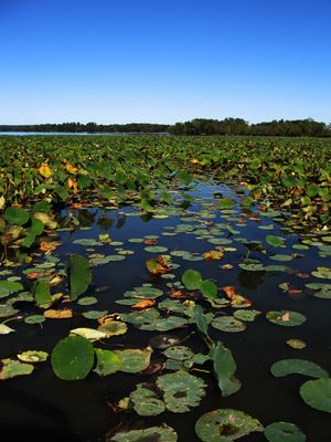
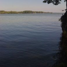
Pymatuning State Park is a nature area of about 3,500 acres centered on a large lake that straddles the Ohio-Pennsylvania border. The park provides water recreation opportunities and natural settings for outdoor activities year-round.
The land was originally home to the Lenape people before the Seneca took control and shaped the region's future. The name Pymatuning comes from a Seneca chief whose legacy is preserved in the park's name today.
Two ancient mounds built by early Native American peoples rest beneath the waters of Pymatuning Lake, speaking to the human presence that once shaped this land. These submerged sites remind visitors that the lake holds layers of history in its depths.
The park has nearly 400 campsites with electric hookups, showers, and full facilities for overnight visitors. Access to the water and hiking trails is straightforward, with clear signs throughout the grounds.
The lake's northeastern section serves as a protected refuge where thousands of wild geese and ducks gather during winter months. This secluded area allows visitors to witness large bird congregations in their natural seasonal movements.
Location: Ashtabula County
Inception: 1950
Shares border with: Pymatuning State Park
Website: https://ohiodnr.gov/wps/portal/gov/odnr/go-and-do/plan-a-visit/find-a-property/pymatuning-state-park
GPS coordinates: 41.60670,-80.53220
Latest update: December 12, 2025 07:54
Conneaut Lake Park
18.4 km
Blue Streak
18.1 km
Pymatuning State Park
9.9 km
Clarence Darrow Octagon House
18 km
Benetka Road Covered Bridge
29.9 km
Gibson House
15.6 km
Toboggan
18.4 km
Riverdale Road Covered Bridge
29.2 km
Congregational-Presbyterian Church
18.2 km
Caine Road Covered Bridge
18.9 km
Ashtabula County Courthouse Group
24.6 km
Joshua Reed Giddings Law Office
24.7 km
Root Road Covered Bridge
26.3 km
Doyle Road Covered Bridge
27.6 km
Dr. Peter Allen House
17.7 km
Giddings Road Covered Bridge
24.2 km
Netcher Road Covered Bridge
22.1 km
Quaker Bridge
24.1 km
South Denmark Road Covered Bridge
18 km
Graham Road Covered Bridge
20.7 km
Bridge in East Fallowfield Township
18.1 km
Kidd's Mills Covered Bridge Historic District
30.3 km
Greenville Commercial Historic District
25.2 km
Alexander P. and James S. Waugh House
28.6 km
Griggs Grange No. 1467
25.2 km
L. W. Peck House
28.8 km
Darrow Octagon House - Clarence Darrow (1857-1938)
18 km
Benjamin F. Wade House
24.6 kmVisited this place? Tap the stars to rate it and share your experience / photos with the community! Try now! You can cancel it anytime.
Discover hidden gems everywhere you go!
From secret cafés to breathtaking viewpoints, skip the crowded tourist spots and find places that match your style. Our app makes it easy with voice search, smart filtering, route optimization, and insider tips from travelers worldwide. Download now for the complete mobile experience.
A unique approach to discovering new places❞
— Le Figaro
All the places worth exploring❞
— France Info
A tailor-made excursion in just a few clicks❞
— 20 Minutes