Enable Location

We need your location to show you interesting places around you

Discover nearby places

Find interesting locations and hidden gems around you

Precise directions

Get accurate directions and distances to places

Your location is never shared with other users. It's only used when you tap the location button.

Red River State Recreation Area

Log in to your account

Start exploring — it's free

Trusted by 61,909 travelers worldwide

Continue with Google
Continue with Apple
or

We will send you a code to connect

By continuing, you accept our Terms and Conditions and our Privacy Policy

Check your inbox

We've sent a pincode in your inbox. Please enter the code below.

Red River State Recreation Area

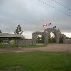
Red River State Recreation Area, Recreation area in East Grand Forks, United States.

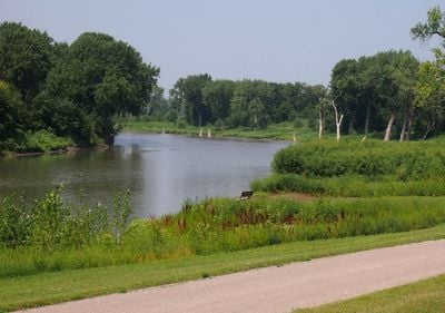
Red River State Recreation Area is a large recreation zone spanning around 1,200 acres near the Red River of the North in Minnesota. It offers multiple camping sites, hiking trails, and picnic areas for visitors to enjoy outdoor activities.

The Minnesota Department of Natural Resources established this recreation area in 1997 following a major river flood that had damaged the region. The creation of this space was part of rebuilding and restoring the riverfront after the natural disaster.

Fishing communities from both sides of the state border gather here to catch walleye and pike from the river waters. The place serves as a natural meeting point where locals spend time by the water as part of their everyday outdoor routine.

The area is easily accessible for visitors arriving with different activity plans such as hiking, fishing, or camping. Plan your visit around quieter times if you prefer fewer crowds, as the space draws many people during warm weather months.

This recreation area sits at the meeting point of two rivers: the Red River of the North and the Red Lake River. The location marks an important node in the broader Greater Grand Forks Greenway system, making it a distinctive spot where two waterways converge.

The community of curious travelers

AroundUs brings together thousands of curated places, local tips, and hidden gems, enriched daily by 60,000 contributors worldwide.

Start exploring
Location
Inception
1997
GPS coordinates
47.93280,-97.03560
Latest update
December 14, 2025 11:24
Around this place
North Dakota Mill and Elevator
United States of America

North Dakota Mill and Elevator

1.7 km
Greater Grand Forks Greenway
United States of America

Greater Grand Forks Greenway

932 m
Sorlie Memorial Bridge
United States of America

Sorlie Memorial Bridge

873 m
Metropolitan Opera House
United States of America

Metropolitan Opera House

1.1 km
United Lutheran Church
United States of America

United Lutheran Church

1.6 km
St. Michael's Church
United States of America

St. Michael's Church

749 m
Dr. Henry Wheeler House
United States of America

Dr. Henry Wheeler House

1.6 km
First National Bank
United States of America

First National Bank

960 m
Grand Forks City Hall
United States of America

Grand Forks City Hall

783 m
Washington School
United States of America

Washington School

772 m
Grand Forks County Courthouse
United States of America

Grand Forks County Courthouse

1.2 km
Ronald N. Davies Federal Building and U.S. Courthouse
United States of America

Ronald N. Davies Federal Building and U.S. Courthouse

839 m
Harriet and Thomas Beare House
United States of America

Harriet and Thomas Beare House

1.8 km
Odd Fellows Block
United States of America

Odd Fellows Block

1.1 km
Oxford House
United States of America

Oxford House

3.1 km
R.S. Blome Granitoid Pavement in Grand Forks
United States of America

R.S. Blome Granitoid Pavement in Grand Forks

984 m
Grand Forks Woolen Mills
United States of America

Grand Forks Woolen Mills

634 m
New Hampshire Apartments
United States of America

New Hampshire Apartments

813 m
J. Nelson Kelly House
United States of America

J. Nelson Kelly House

1.7 km
Grand Forks County Fairgrounds WPA Structures
United States of America

Grand Forks County Fairgrounds WPA Structures

1.8 km
Grand Forks Riverside Neighborhood Historic District
United States of America

Grand Forks Riverside Neighborhood Historic District

697 m
George B. Clifford House
United States of America

George B. Clifford House

1.7 km
Dinnie Apartments
United States of America

Dinnie Apartments

1.8 km
Skarsbo Apartments
United States of America

Skarsbo Apartments

913 m
University of North Dakota Historic District
United States of America

University of North Dakota Historic District

2.8 km
North Dakota Museum of Art
United States of America

North Dakota Museum of Art

3.2 km
Grand Forks County Historical Society
United States of America

Grand Forks County Historical Society

4.1 km
Joseph Bell DeRemer House
United States of America

Joseph Bell DeRemer House

2 km
Show the full map
« Red River State Recreation Area - Recreation area in East Grand Forks, United States » is provided by Around Us (aroundus.com). Images and texts are derived from Wikimedia project under a Creative Commons license. You are allowed to copy, distribute, and modify copies of this page, under the conditions set by the license, as long as this note is clearly visible.

Discover hidden gems everywhere you go!

From secret cafés to breathtaking viewpoints, skip the crowded tourist spots and find places that match your style. Our app makes it easy with voice search, smart filtering, route optimization, and insider tips from travelers worldwide. Download now for the complete mobile experience.

Around Us App Screenshot

A unique approach to discovering new places

Le Figaro

All the places worth exploring

France Info

A tailor-made excursion in just a few clicks

20 Minutes

Around Us
Travel Guide & Maps
Download

Send to your phone

QR Code
1

Open the camera app on your mobile.

2

Point at the QR code with your camera. A notification will appear.

3

Tap the notification to open the link.