Enable Location

We need your location to show you interesting places around you

Discover nearby places

Find interesting locations and hidden gems around you

Precise directions

Get accurate directions and distances to places

Your location is never shared with other users. It's only used when you tap the location button.

Rockaway Creek

Log in to your account

Start exploring — it's free

Trusted by 61,319 travelers worldwide

Continue with Google
Continue with Apple
or

We will send you a code to connect

By continuing, you accept our Terms and Conditions and our Privacy Policy

Check your inbox

We've sent a pincode in your inbox. Please enter the code below.

Rockaway Creek

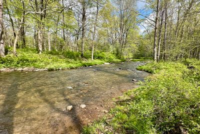
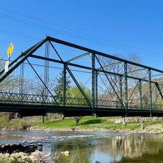
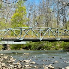
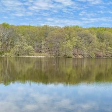
Rockaway Creek, Tributary in Hunterdon County, US.

Description

Rockaway Creek is a tributary flowing through Hunterdon County, New Jersey, as part of the broader Raritan watershed. It covers a substantial drainage area and connects to the larger river network that serves the region.

History

Scientists began observing this creek in the late 1970s and established continuous monitoring practices. The long-term records provide insights into how the waterway has responded to environmental changes over the decades.

Culture

The water monitoring station at Rockaway Creek serves as an educational resource for environmental scientists and researchers studying water quality patterns.

Practical

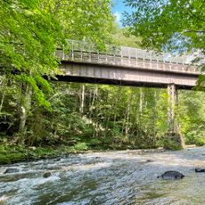
The site is accessible from local roads in Hunterdon County and sits at a relatively low elevation in the river valley. Visitors should be prepared for varying water levels depending on seasonal rainfall and weather conditions.

Did you know?

The creek maintains a monitoring station at an elevation of 121.5 feet, collecting data across 11.3 square miles of drainage area.

Location
GPS coordinates
40.67720,-74.79640
Latest update
December 14, 2025 16:43

AroundUs brings together thousands of curated places, local tips, and hidden gems, enriched daily by 60,000 contributors worldwide. Discover all places nearby (Hunterdon County).

Around this place
United States of America

Round Valley Reservoir

7.4 km
Pennsylvania Railroad 4877
United States of America

Pennsylvania Railroad 4877

5.6 km
Ken Lockwood Gorge Bridge
United States of America

Ken Lockwood Gorge Bridge

6.8 km
Main Street Bridge
United States of America

Main Street Bridge

6 km
Oldwick Historic District
United States of America

Oldwick Historic District

4 km
Taylor's Mill Historic District
United States of America

Taylor's Mill Historic District

3.1 km
Hoffman's Crossing Road Bridge
United States of America

Hoffman's Crossing Road Bridge

6.4 km
Bartles House
United States of America

Bartles House

4 km
Lamington Historic District
United States of America

Lamington Historic District

6.9 km
Fairmount Historic District
United States of America

Fairmount Historic District

5 km
J. K. Apgar Farmhouse
United States of America

J. K. Apgar Farmhouse

5.1 km
Kline Farmhouse
United States of America

Kline Farmhouse

3.8 km
Whitehouse-Mechanicsville Historic District
United States of America

Whitehouse-Mechanicsville Historic District

7 km
Lower Valley Presbyterian Church
United States of America

Lower Valley Presbyterian Church

6.9 km
Zion Lutheran Church
United States of America

Zion Lutheran Church

4 km
Union Forge Bridge
United States of America

Union Forge Bridge

7.7 km
Califon Methodist Episcopal Church
United States of America

Califon Methodist Episcopal Church

6 km
Califon
United States of America

Califon

5.8 km
Cokesbury United Methodist Church
United States of America

Cokesbury United Methodist Church

3.3 km
Pottersville Reformed Church
United States of America

Pottersville Reformed Church

7.7 km
Califon Historic District
United States of America

Califon Historic District

5.7 km
Mountainville Historic District
United States of America

Mountainville Historic District

1.9 km
Lake Solitude
United States of America

Lake Solitude

7.5 km
Readingsburg Historic District
United States of America

Readingsburg Historic District

6.9 km
Cokesbury Historic District
United States of America

Cokesbury Historic District

3.6 km
Potterstown Rural Historic District
United States of America

Potterstown Rural Historic District

3.6 km
Solitude House
United States of America

Solitude House

7.6 km
Pottersville Village Historic District
United States of America

Pottersville Village Historic District

7.6 km
Show the full map
« Rockaway Creek - Tributary in Hunterdon County, US » is provided by Around Us (aroundus.com). Images and texts are derived from Wikimedia project under a Creative Commons license. You are allowed to copy, distribute, and modify copies of this page, under the conditions set by the license, as long as this note is clearly visible.

Discover hidden gems everywhere you go!

From secret cafés to breathtaking viewpoints, skip the crowded tourist spots and find places that match your style. Our app makes it easy with voice search, smart filtering, route optimization, and insider tips from travelers worldwide. Download now for the complete mobile experience.

Around Us App Screenshot

A unique approach to discovering new places

Le Figaro

All the places worth exploring

France Info

A tailor-made excursion in just a few clicks

20 Minutes

Around Us
Travel Guide & Maps
Download

Send to your phone

QR Code
1

Open the camera app on your mobile.

2

Point at the QR code with your camera. A notification will appear.

3

Tap the notification to open the link.