Enable Location

We need your location to show you interesting places around you

Discover nearby places

Find interesting locations and hidden gems around you

Precise directions

Get accurate directions and distances to places

Your location is never shared with other users. It's only used when you tap the location button.

Main Street Bridge

Log in to your account

Start exploring — it's free

Trusted by 62,346 travelers worldwide

Continue with Google
Continue with Apple
or

We will send you a code to connect

By continuing, you accept our Terms and Conditions and our Privacy Policy

Check your inbox

We've sent a pincode in your inbox. Please enter the code below.

Main Street Bridge

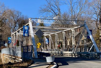
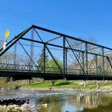
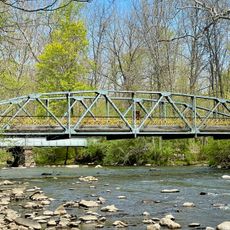
Main Street Bridge, Iron truss bridge in Califon, United States

Main Street Bridge is an iron truss structure crossing the South Branch Raritan River in Califon, featuring original Pratt through trusses as its primary structural system. The span extends across the water with a roadway that accommodates two-way traffic, supporting the local transportation network through the center of town.

The structure was built in 1887 by I P Bartley & Company from Mount Olive Township and has shaped the local infrastructure since then. In the 1980s, it received strengthening work to meet modern traffic demands and continue serving the community.

This bridge serves as a practical link in the historic center of Califon, connecting both sides of the community along a road that residents and visitors use daily. It stands for a time when engineering structures formed the backbone of local infrastructure and allowed the community to grow.

The bridge is accessible from the main street running through Califon and is easy to reach on foot or by car since it sits in the center of town. It is best viewed during daylight hours when you can clearly see the iron framework and its surroundings.

This structure is one of the few surviving works by engineer I P Bartley and showcases the skilled craftsmanship of bridge builders in late 19th-century New Jersey. The blend of original components and later reinforcements shows how older infrastructure was adapted to meet modern demands without losing its character.

The community of curious travelers

AroundUs brings together thousands of curated places, local tips, and hidden gems, enriched daily by 60,000 contributors worldwide.

Start exploring
Location
Inception
1887
GPS coordinates
40.72056,-74.83764
Latest update
December 14, 2025 13:07
Around this place
Voorhees State Park
United States of America

Voorhees State Park

5 km
Ken Lockwood Gorge Bridge
United States of America

Ken Lockwood Gorge Bridge

3.9 km
Rockaway Creek
United States of America

Rockaway Creek

6 km
German Valley Historic District
United States of America

German Valley Historic District

8.6 km
Paul Robinson Observatory
United States of America

Paul Robinson Observatory

6.7 km
Taylor's Mill Historic District
United States of America

Taylor's Mill Historic District

8.9 km
Hoffman's Crossing Road Bridge
United States of America

Hoffman's Crossing Road Bridge

2.5 km
Fairmount Historic District
United States of America

Fairmount Historic District

5.3 km
J. K. Apgar Farmhouse
United States of America

J. K. Apgar Farmhouse

994 m
Miller Farmstead
United States of America

Miller Farmstead

8.7 km
Kline Farmhouse
United States of America

Kline Farmhouse

8.7 km
Spruce Run Evangelical Lutheran Zion Church
United States of America

Spruce Run Evangelical Lutheran Zion Church

7.3 km
Anthony-Corwin Farm
United States of America

Anthony-Corwin Farm

6.2 km
Craft-Clausen House
United States of America

Craft-Clausen House

7.9 km
Leonard Neighbor Farmstead
United States of America

Leonard Neighbor Farmstead

7 km
Jacob Wise Neighbor House
United States of America

Jacob Wise Neighbor House

7.6 km
Lower Valley Presbyterian Church
United States of America

Lower Valley Presbyterian Church

990 m
Union Forge Bridge
United States of America

Union Forge Bridge

7.1 km
Califon Methodist Episcopal Church
United States of America

Califon Methodist Episcopal Church

235 m
Califon
United States of America

Califon

186 m
Cokesbury United Methodist Church
United States of America

Cokesbury United Methodist Church

4.2 km
Califon Historic District
United States of America

Califon Historic District

241 m
Lake Solitude
United States of America

Lake Solitude

6.5 km
Mountainville Historic District
United States of America

Mountainville Historic District

4 km
Cokesbury Historic District
United States of America

Cokesbury Historic District

4.1 km
Middle Valley Historic District
United States of America

Middle Valley Historic District

4.4 km
Readingsburg Historic District
United States of America

Readingsburg Historic District

5.5 km
Solitude House
United States of America

Solitude House

6.9 km
Show the full map
« Main Street Bridge - Iron truss bridge in Califon, United States » is provided by Around Us (aroundus.com). Images and texts are derived from Wikimedia project under a Creative Commons license. You are allowed to copy, distribute, and modify copies of this page, under the conditions set by the license, as long as this note is clearly visible.

Discover hidden gems everywhere you go!

From secret cafés to breathtaking viewpoints, skip the crowded tourist spots and find places that match your style. Our app makes it easy with voice search, smart filtering, route optimization, and insider tips from travelers worldwide. Download now for the complete mobile experience.

Around Us App Screenshot

A unique approach to discovering new places

Le Figaro

All the places worth exploring

France Info

A tailor-made excursion in just a few clicks

20 Minutes

Around Us
Travel Guide & Maps
Download

Send to your phone

QR Code
1

Open the camera app on your mobile.

2

Point at the QR code with your camera. A notification will appear.

3

Tap the notification to open the link.