Enable Location

We need your location to show you interesting places around you

Discover nearby places

Find interesting locations and hidden gems around you

Precise directions

Get accurate directions and distances to places

Your location is never shared with other users. It's only used when you tap the location button.

Voorhees State Park

Log in to your account

Start exploring — it's free

Trusted by 65,115 travelers worldwide

Continue with Google
Continue with Apple
or

We will send you a code to connect

By continuing, you accept our Terms and Conditions and our Privacy Policy

Check your inbox

We've sent a pincode in your inbox. Please enter the code below.

Voorhees State Park
Discussion Reviews 1 Photos
3k Popularity

Voorhees State Park, State park and nature reserve in Hunterdon County, New Jersey, United States

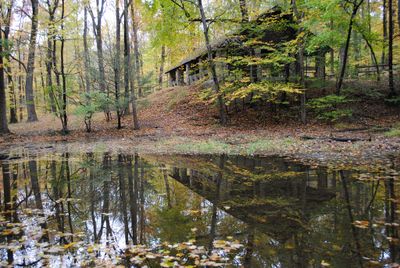
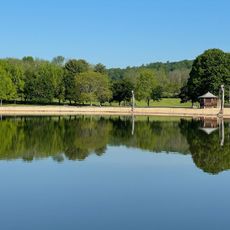
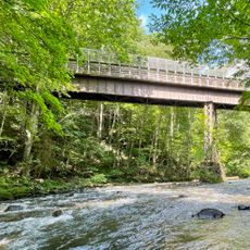
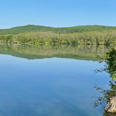
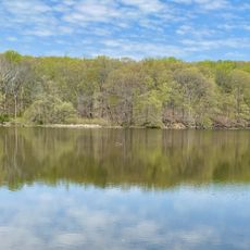
Voorhees State Park is a nature reserve and state park in Hunterdon County, New Jersey, covering wooded hills, several trails, and a small lake ringed by dense forest. The park also has designated picnic areas and camping sites spread across the property.

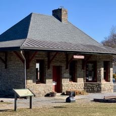
The park was created in 1929 when Foster McGowan Voorhees, a former governor of New Jersey, donated his farm to the state for public use. Over the following years, a federal work program brought in young men who built the trails, shelters, and other structures still standing today.

The stone shelters and trail markers built by young workers in the 1930s are still in use today and give the park a layered, handmade quality. Visitors walking the paths can notice how the stonework and wooden structures were shaped by hand, not machine.

Camping with fire rings, picnic tables, and bathrooms is available from April through October, while day visitors can walk the trails year-round. Spring and fall bring big swings in temperature, so layering clothes makes sense when planning a visit during those seasons.

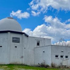
The New Jersey Astronomical Association runs an observatory inside the park that holds one of the largest telescopes owned by a private organization in the state. On clear nights, the sky above the park is dark enough to make out distant planets and star clusters with the naked eye.

The community of curious travelers

AroundUs brings together thousands of curated places, local tips, and hidden gems, enriched daily by 60,000 contributors worldwide.

Start exploring
Location
Inception
1927
GPS coordinates
40.69598,-74.88713
Latest update
March 3, 2026 13:54
Around this place
Spruce Run Recreation Area
United States of America

Spruce Run Recreation Area

5.7 km
Red Mill
United States of America

Red Mill

7 km
Hunterdon Art Museum
United States of America

Hunterdon Art Museum

7 km
Ken Lockwood Gorge Bridge
United States of America

Ken Lockwood Gorge Bridge

1.3 km
Clinton Historic District
United States of America

Clinton Historic District

6.7 km
Main Street Bridge
United States of America

Main Street Bridge

7 km
Paul Robinson Observatory
United States of America

Paul Robinson Observatory

1.8 km
Dunham's Mill
United States of America

Dunham's Mill

7 km
M. C. Mulligan & Sons Quarry
United States of America

M. C. Mulligan & Sons Quarry

7 km
Glen Gardner Pony Pratt Truss Bridge
United States of America

Glen Gardner Pony Pratt Truss Bridge

4.8 km
Hoffman's Crossing Road Bridge
United States of America

Hoffman's Crossing Road Bridge

2.5 km
Red Mill Museum Village
United States of America

Red Mill Museum Village

7 km
Christoffel Vought Farmstead
United States of America

Christoffel Vought Farmstead

5.9 km
Spruce Run Evangelical Lutheran Zion Church
United States of America

Spruce Run Evangelical Lutheran Zion Church

3.3 km
Old Grandin Library
United States of America

Old Grandin Library

6.8 km
Music Hall
United States of America

Music Hall

7.3 km
Union Forge Bridge
United States of America

Union Forge Bridge

3 km
Califon Methodist Episcopal Church
United States of America

Califon Methodist Episcopal Church

4.8 km
Spruce Run Reservoir
United States of America

Spruce Run Reservoir

6.1 km
Califon
United States of America

Califon

4.9 km
Cokesbury United Methodist Church
United States of America

Cokesbury United Methodist Church

4.6 km
1760 Joseph Turner House
United States of America

1760 Joseph Turner House

7.5 km
Califon Historic District
United States of America

Califon Historic District

5 km
Lake Solitude
United States of America

Lake Solitude

2.4 km
Annandale Historic District
United States of America

Annandale Historic District

5.9 km
Solitude House
United States of America

Solitude House

2.8 km
Readingsburg Historic District
United States of America

Readingsburg Historic District

1.8 km
Cokesbury Historic District
United States of America

Cokesbury Historic District

4.4 km
Show the full map
Reviews
Share your experience

No review yet

Discussions
Start a discussion...

No discussion yet

« Voorhees State Park - State park and nature reserve in Hunterdon County, New Jersey, United States » is provided by Around Us (aroundus.com). Images and texts are derived from Wikimedia project under a Creative Commons license. You are allowed to copy, distribute, and modify copies of this page, under the conditions set by the license, as long as this note is clearly visible.

Discover hidden gems everywhere you go!

From secret cafés to breathtaking viewpoints, skip the crowded tourist spots and find places that match your style. Our app makes it easy with voice search, smart filtering, route optimization, and insider tips from travelers worldwide. Download now for the complete mobile experience.

Around Us App Screenshot

A unique approach to discovering new places

Le Figaro

All the places worth exploring

France Info

A tailor-made excursion in just a few clicks

20 Minutes

Around Us
Travel Guide & Maps
Download

Send to your phone

QR Code
1

Open the camera app on your mobile.

2

Point at the QR code with your camera. A notification will appear.

3

Tap the notification to open the link.