Enable Location

We need your location to show you interesting places around you

Discover nearby places

Find interesting locations and hidden gems around you

Precise directions

Get accurate directions and distances to places

Your location is never shared with other users. It's only used when you tap the location button.

Spruce Run Recreation Area

Log in to your account

Start exploring — it's free

Trusted by 63,075 travelers worldwide

Continue with Google
Continue with Apple
or

We will send you a code to connect

By continuing, you accept our Terms and Conditions and our Privacy Policy

Check your inbox

We've sent a pincode in your inbox. Please enter the code below.

Spruce Run Recreation Area
Discussion Reviews 1 Photos
7.3k Popularity

Spruce Run Recreation Area, State recreation area in Hunterdon County, United States

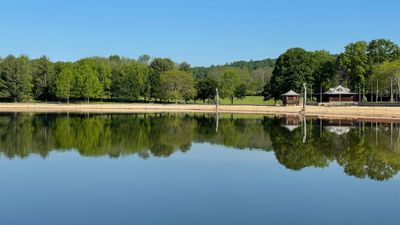
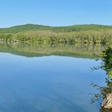
Spruce Run Recreation Area is a 1,290-acre park centered around a reservoir with 15 miles of shoreline that supports multiple recreational activities. The grounds include designated camping zones, day-use picnic areas, hiking trails, and access points for boating and fishing along the water.

The reservoir was constructed in 1964 as one of New Jersey's earliest state-managed water supply projects created under the 1958 Water Supply Law. This infrastructure development reflected the state's need to manage growing water demand across the region.

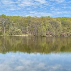
The reservoir is an important gathering place for local anglers who come to fish for bass, catfish, and sunfish throughout the year. The fishing community shapes daily life on the water and reveals how much the area depends on its aquatic resources.

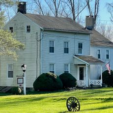
The park provides 67 campsites with picnic tables and fire rings available during the warmer months for overnight stays. Modern bathhouse facilities with showers operate from April through October, so visitors should plan visits accordingly based on when they need full amenities.

The reservoir serves as an emergency backup water source that feeds into the south branch of the Raritan River during drought conditions when natural flows drop too low. This hidden function reveals that the site plays a critical role in regional water management beyond recreation.

The community of curious travelers

AroundUs brings together thousands of curated places, local tips, and hidden gems, enriched daily by 60,000 contributors worldwide.

Start exploring
Location
GPS coordinates
40.66278,-74.93889
Latest update
December 8, 2025 20:03
Around this place
Red Mill
United States of America

Red Mill

3.7 km
Voorhees State Park
United States of America

Voorhees State Park

5.7 km
United States of America

Musconetcong Mountain

6 km
Fink-Type Truss Bridge
United States of America

Fink-Type Truss Bridge

7.2 km
Hunterdon Art Museum
United States of America

Hunterdon Art Museum

3.7 km
Ken Lockwood Gorge Bridge
United States of America

Ken Lockwood Gorge Bridge

6.8 km
Clinton Historic District
United States of America

Clinton Historic District

3.7 km
Main Street Bridge
United States of America

Main Street Bridge

3.7 km
Perryville Tavern
United States of America

Perryville Tavern

4.2 km
Paul Robinson Observatory
United States of America

Paul Robinson Observatory

4 km
Dunham's Mill
United States of America

Dunham's Mill

3.7 km
M. C. Mulligan & Sons Quarry
United States of America

M. C. Mulligan & Sons Quarry

3.6 km
Glen Gardner Pony Pratt Truss Bridge
United States of America

Glen Gardner Pony Pratt Truss Bridge

4.3 km
Red Mill Museum Village
United States of America

Red Mill Museum Village

3.6 km
Christoffel Vought Farmstead
United States of America

Christoffel Vought Farmstead

4.1 km
Spruce Run Evangelical Lutheran Zion Church
United States of America

Spruce Run Evangelical Lutheran Zion Church

5.2 km
Lansdown
United States of America

Lansdown

6.9 km
Old Grandin Library
United States of America

Old Grandin Library

3.8 km
Rockhill Agricultural Historic District
United States of America

Rockhill Agricultural Historic District

7.1 km
Music Hall
United States of America

Music Hall

3.9 km
Bethlehem United Presbyterian Church
United States of America

Bethlehem United Presbyterian Church

5 km
Union Forge Bridge
United States of America

Union Forge Bridge

4.4 km
Spruce Run Reservoir
United States of America

Spruce Run Reservoir

1.3 km
1760 Joseph Turner House
United States of America

1760 Joseph Turner House

1.9 km
Lake Solitude
United States of America

Lake Solitude

4.7 km
Readingsburg Historic District
United States of America

Readingsburg Historic District

5.6 km
Solitude House
United States of America

Solitude House

4.6 km
Annandale Historic District
United States of America

Annandale Historic District

5.4 km
Show the full map
Reviews
Share your experience

No review yet

Discussions
Start a discussion...

No discussion yet

« Spruce Run Recreation Area - State recreation area in Hunterdon County, United States » is provided by Around Us (aroundus.com). Images and texts are derived from Wikimedia project under a Creative Commons license. You are allowed to copy, distribute, and modify copies of this page, under the conditions set by the license, as long as this note is clearly visible.

Discover hidden gems everywhere you go!

From secret cafés to breathtaking viewpoints, skip the crowded tourist spots and find places that match your style. Our app makes it easy with voice search, smart filtering, route optimization, and insider tips from travelers worldwide. Download now for the complete mobile experience.

Around Us App Screenshot

A unique approach to discovering new places

Le Figaro

All the places worth exploring

France Info

A tailor-made excursion in just a few clicks

20 Minutes

Around Us
Travel Guide & Maps
Download

Send to your phone

QR Code
1

Open the camera app on your mobile.

2

Point at the QR code with your camera. A notification will appear.

3

Tap the notification to open the link.