Enable Location

We need your location to show you interesting places around you

Discover nearby places

Find interesting locations and hidden gems around you

Precise directions

Get accurate directions and distances to places

Your location is never shared with other users. It's only used when you tap the location button.

Silver Lake State Park

Log in to your account

Start exploring — it's free

Trusted by 62,087 travelers worldwide

Continue with Google
Continue with Apple
or

We will send you a code to connect

By continuing, you accept our Terms and Conditions and our Privacy Policy

Check your inbox

We've sent a pincode in your inbox. Please enter the code below.

Silver Lake State Park

Silver Lake State Park, Recreation area in Hollis, United States.

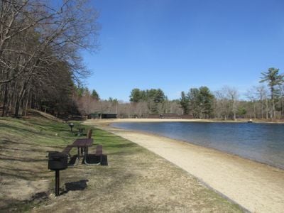
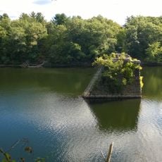
Silver Lake State Park is a recreation area centered on a sandy beach along the north side of the lake. The park spans about 32 hectares and provides space for swimming, picnicking, and relaxing by the water.

The park was established in 1954 as part of New Hampshire's larger effort to conserve natural areas for public use. This founding helped protect the region for future generations.

The park embodies New Hampshire's commitment to environmental care through its carry-in, carry-out program, which invites visitors to take responsibility for keeping the space clean. This practice reflects values shared by the local community about respecting natural places.

The grounds are easy to access with adequate parking and clear paths leading to the beach. Visitors should bring swimwear and sun protection depending on the season, as shaded areas are limited.

The park connects to the nearby Spalding Town Forest through several hiking trails, allowing visitors to extend their exploration beyond the beach area. This link creates a larger network of paths and woodland.

The community of curious travelers

AroundUs brings together thousands of curated places, local tips, and hidden gems, enriched daily by 60,000 contributors worldwide.

Start exploring
Location
GPS coordinates
42.76250,-71.59390
Latest update
December 14, 2025 11:22
Around this place
Nashua Public Library
United States of America

Nashua Public Library

10.6 km
Andres Institute of Art
United States of America

Andres Institute of Art

7.3 km
Nashville Historic District
United States of America

Nashville Historic District

10.4 km
Signer's House and Matthew Thornton Cemetery
United States of America

Signer's House and Matthew Thornton Cemetery

12 km
Nashua Manufacturing Company Historic District
United States of America

Nashua Manufacturing Company Historic District

9.9 km
Milford Suspension Bridge
United States of America

Milford Suspension Bridge

9.3 km
United States of America

Potanipo Hill

7.6 km
Hills Memorial Library
United States of America

Hills Memorial Library

12.7 km
Abbot House
United States of America

Abbot House

10.2 km
Soldiers and Sailors Monument
United States of America

Soldiers and Sailors Monument

10.3 km
Amherst Village Historic District
United States of America

Amherst Village Historic District

11.5 km
Hunt Memorial Library
United States of America

Hunt Memorial Library

10.4 km
Hillsborough County Registry of Deeds
United States of America

Hillsborough County Registry of Deeds

10.5 km
Killicut-Way House
United States of America

Killicut-Way House

10.6 km
G.O. Sanders House
United States of America

G.O. Sanders House

12.5 km
William Peabody House
United States of America

William Peabody House

10.8 km
Hollis Village Historic District
United States of America

Hollis Village Historic District

2.8 km
McClure-Hilton House
United States of America

McClure-Hilton House

7.6 km
Gen. George Stark House
United States of America

Gen. George Stark House

10.3 km
The Meetinghouse
United States of America

The Meetinghouse

2.6 km
Marion Nichols Summer Home
United States of America

Marion Nichols Summer Home

3.2 km
Milford Town House and Library Annex
United States of America

Milford Town House and Library Annex

9.3 km
Pepperell Center Historic District
United States of America

Pepperell Center Historic District

10.6 km
Mine Falls Park
United States of America

Mine Falls Park

7.5 km
Pepperell Covered Bridge
United States of America

Pepperell Covered Bridge

10.4 km
B&M Merrimack River Bridge
United States of America

B&M Merrimack River Bridge

12.4 km
Runnels Bridge
United States of America

Runnels Bridge

6.7 km
Daniel Webster Highway Bridge
United States of America

Daniel Webster Highway Bridge

10.4 km
Show the full map
« Silver Lake State Park - Recreation area in Hollis, United States » is provided by Around Us (aroundus.com). Images and texts are derived from Wikimedia project under a Creative Commons license. You are allowed to copy, distribute, and modify copies of this page, under the conditions set by the license, as long as this note is clearly visible.

Discover hidden gems everywhere you go!

From secret cafés to breathtaking viewpoints, skip the crowded tourist spots and find places that match your style. Our app makes it easy with voice search, smart filtering, route optimization, and insider tips from travelers worldwide. Download now for the complete mobile experience.

Around Us App Screenshot

A unique approach to discovering new places

Le Figaro

All the places worth exploring

France Info

A tailor-made excursion in just a few clicks

20 Minutes

Around Us
Travel Guide & Maps
Download

Send to your phone

QR Code
1

Open the camera app on your mobile.

2

Point at the QR code with your camera. A notification will appear.

3

Tap the notification to open the link.