Enable Location

We need your location to show you interesting places around you

Discover nearby places

Find interesting locations and hidden gems around you

Precise directions

Get accurate directions and distances to places

Your location is never shared with other users. It's only used when you tap the location button.

Ship John Shoal Light

Log in to your account

Start exploring — it's free

Trusted by 62,316 travelers worldwide

Continue with Google
Continue with Apple
or

We will send you a code to connect

By continuing, you accept our Terms and Conditions and our Privacy Policy

Check your inbox

We've sent a pincode in your inbox. Please enter the code below.

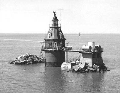
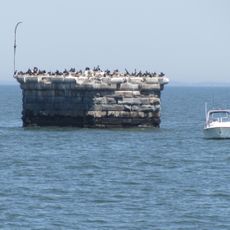
Ship John Shoal Light, Offshore lighthouse in Delaware Bay, United States.

Ship John Shoal Light is a 14-meter-tall structure with an octagonal shape and mansard roof, topped by a black lantern on a brown foundation. The lighthouse stands on a shoal in Delaware Bay and has been powered by solar energy since 1977.

The lighthouse takes its name from the ship John, which ran aground in 1797 during a voyage from Hamburg to Philadelphia. That maritime incident left a lasting name for the treacherous shoal.

The cast iron structure was displayed at Philadelphia's 1876 Centennial Exposition before being installed on the shoal. This demonstrates how technological advances in maritime safety were celebrated during that era.

The lighthouse is surrounded by water and can only be reached by boat. Visitors should prepare for open water conditions and bring appropriate footwear and gear for a marine excursion.

The foundation required massive riprap protection against ice damage, with additional reinforcement added in 1907 including a concrete platform. These extensive safeguards reveal the extreme challenges that structures face in this harsh water environment.

The community of curious travelers

AroundUs brings together thousands of curated places, local tips, and hidden gems, enriched daily by 60,000 contributors worldwide.

Start exploring
Inception
1877
Height
14 m
GPS coordinates
39.30529,-75.37666
Latest update
December 12, 2025 14:23
Around this place
Bombay Hook National Wildlife Refuge
United States of America

Bombay Hook National Wildlife Refuge

9.8 km
Elbow of Cross Ledge Light
United States of America

Elbow of Cross Ledge Light

16.6 km
Bethel African Methodist Episcopal Church
United States of America

Bethel African Methodist Episcopal Church

12.7 km
Cross Ledge Light
United States of America

Cross Ledge Light

16.9 km
Allee House
United States of America

Allee House

11.3 km
Wheel of Fortune
United States of America

Wheel of Fortune

15.5 km
Snowland
United States of America

Snowland

15.5 km
Woodland Beach Wildlife Area
United States of America

Woodland Beach Wildlife Area

11.1 km
Sipple House
United States of America

Sipple House

14.1 km
John M. Voshell House
United States of America

John M. Voshell House

12.2 km
Greenwich Historic District
United States of America

Greenwich Historic District

10.7 km
Ruth Mansion House
United States of America

Ruth Mansion House

13.9 km
Thomas Sutton House
United States of America

Thomas Sutton House

11.4 km
Little Creek Methodist Church
United States of America

Little Creek Methodist Church

16.9 km
Timothy Cummins House
United States of America

Timothy Cummins House

14.4 km
George Farmhouse
United States of America

George Farmhouse

14.9 km
Thomas Maskel House
United States of America

Thomas Maskel House

11 km
Fleming House
United States of America

Fleming House

16 km
United States of America

Macomb Farm

16.2 km
Savin-Wilson House
United States of America

Savin-Wilson House

13.9 km
Old Stone Tavern
United States of America

Old Stone Tavern

16.9 km
Reed House
United States of America

Reed House

13.7 km
Mifflin-Marim Agricultural Complex
United States of America

Mifflin-Marim Agricultural Complex

15 km
Peterson and Mustard's Hermitage Farm
United States of America

Peterson and Mustard's Hermitage Farm

16.7 km
Raymond Neck Historic District
United States of America

Raymond Neck Historic District

13.1 km
Alexander Laws House
United States of America

Alexander Laws House

14 km
John and Elizabeth Remington House
United States of America

John and Elizabeth Remington House

16 km
Rawley House
United States of America

Rawley House

13.9 km
Show the full map
« Ship John Shoal Light - Offshore lighthouse in Delaware Bay, United States » is provided by Around Us (aroundus.com). Images and texts are derived from Wikimedia project under a Creative Commons license. You are allowed to copy, distribute, and modify copies of this page, under the conditions set by the license, as long as this note is clearly visible.

Discover hidden gems everywhere you go!

From secret cafés to breathtaking viewpoints, skip the crowded tourist spots and find places that match your style. Our app makes it easy with voice search, smart filtering, route optimization, and insider tips from travelers worldwide. Download now for the complete mobile experience.

Around Us App Screenshot

A unique approach to discovering new places

Le Figaro

All the places worth exploring

France Info

A tailor-made excursion in just a few clicks

20 Minutes

Around Us
Travel Guide & Maps
Download

Send to your phone

QR Code
1

Open the camera app on your mobile.

2

Point at the QR code with your camera. A notification will appear.

3

Tap the notification to open the link.