Enable Location

We need your location to show you interesting places around you

Discover nearby places

Find interesting locations and hidden gems around you

Precise directions

Get accurate directions and distances to places

Your location is never shared with other users. It's only used when you tap the location button.

Slade's Ferry Bridge

Log in to your account

Start exploring — it's free

Trusted by 61,833 travelers worldwide

Continue with Google
Continue with Apple
or

We will send you a code to connect

By continuing, you accept our Terms and Conditions and our Privacy Policy

Check your inbox

We've sent a pincode in your inbox. Please enter the code below.

Slade's Ferry Bridge

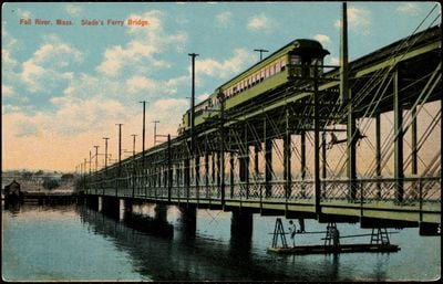
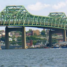
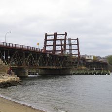
Slade's Ferry Bridge, Railway bridge over Taunton River in Fall River, Massachusetts

Description

Slade's Ferry Bridge was a steel swing truss structure with two levels: the upper deck served the Providence, Warren and Bristol Railroad, while the lower deck accommodated vehicles. This dual-level design allowed the river to be crossed by both trains and automobiles at the same time.

History

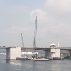
The bridge opened in 1875 and replaced earlier ferry services that connected Somerset and Fall River. Following a ship collision in 1932, the original swing section was redesigned with a bascule mechanism to better accommodate river traffic.

Culture

The bridge served as a working connection between two communities that relied on each other for trade and industrial growth. Visitors could witness how the moving structure cleared the river for ships and then became passable again for trains and vehicles.

Practical

The bridge closed in 1970 and is no longer accessible to visitors walking across it. Your best opportunity to observe the structure is from the riverside paths or through historical photographs and documentation.

Did you know?

What made this bridge distinctive was its innovative two-level design that allowed trains and vehicles to cross the river simultaneously. This engineering solution was uncommon during the industrial era and represented a practical answer to growing transportation needs.

Location
Official opening
1875
GPS coordinates
41.72080,-71.15860
Latest update
December 12, 2025 17:46

AroundUs brings together thousands of curated places, local tips, and hidden gems, enriched daily by 60,000 contributors worldwide. Discover all places nearby (Massachusetts).

Around this place
USS Massachusetts
United States of America

USS Massachusetts

1.7 km
Battleship Cove
United States of America

Battleship Cove

1.6 km
USS Joseph P. Kennedy, Jr.
United States of America

USS Joseph P. Kennedy, Jr.

1.7 km
Charles M. Braga Jr. Memorial Bridge
United States of America

Charles M. Braga Jr. Memorial Bridge

1.7 km
USS Lionfish
United States of America

USS Lionfish

1.7 km
B.M.C. Durfee High School
United States of America

B.M.C. Durfee High School

1.8 km
Fall River Heritage State Park
United States of America

Fall River Heritage State Park

1.7 km
Motor torpedo boat PT-617
United States of America

Motor torpedo boat PT-617

1.8 km
Veterans Memorial Bridge
United States of America

Veterans Memorial Bridge

847 m
Brightman Street Bridge
United States of America

Brightman Street Bridge

430 m
Highlands Historic District
United States of America

Highlands Historic District

1.4 km
Quequechan Club
United States of America

Quequechan Club

599 m
Osborn House
United States of America

Osborn House

1.6 km
St. Joseph's Church
United States of America

St. Joseph's Church

932 m
Sagamore Mills No. 1 and No. 3
United States of America

Sagamore Mills No. 1 and No. 3

1.2 km
First Baptist Church
United States of America

First Baptist Church

1.8 km
Lafayette-Durfee House
United States of America

Lafayette-Durfee House

1.7 km
Bristol County Superior Court
United States of America

Bristol County Superior Court

1.5 km
David M. Anthony House
United States of America

David M. Anthony House

655 m
Barnabus Blossom House
United States of America

Barnabus Blossom House

960 m
William Lindsey House
United States of America

William Lindsey House

575 m
Unitarian Society
United States of America

Unitarian Society

1.7 km
Sagamore Mill No. 2
United States of America

Sagamore Mill No. 2

1.2 km
John M. Earle House
United States of America

John M. Earle House

534 m
William C. Davol, Jr., House
United States of America

William C. Davol, Jr., House

909 m
Motor Torpedo Boat PT 796
United States of America

Motor Torpedo Boat PT 796

1.8 km
John Mace Smith House
United States of America

John Mace Smith House

629 m
James D. Hathaway House
United States of America

James D. Hathaway House

937 m
Show the full map
« Slade's Ferry Bridge - Railway bridge over Taunton River in Fall River, Massachusetts » is provided by Around Us (aroundus.com). Images and texts are derived from Wikimedia project under a Creative Commons license. You are allowed to copy, distribute, and modify copies of this page, under the conditions set by the license, as long as this note is clearly visible.

Discover hidden gems everywhere you go!

From secret cafés to breathtaking viewpoints, skip the crowded tourist spots and find places that match your style. Our app makes it easy with voice search, smart filtering, route optimization, and insider tips from travelers worldwide. Download now for the complete mobile experience.

Around Us App Screenshot

A unique approach to discovering new places

Le Figaro

All the places worth exploring

France Info

A tailor-made excursion in just a few clicks

20 Minutes

Around Us
Travel Guide & Maps
Download

Send to your phone

QR Code
1

Open the camera app on your mobile.

2

Point at the QR code with your camera. A notification will appear.

3

Tap the notification to open the link.