Enable Location

We need your location to show you interesting places around you

Discover nearby places

Find interesting locations and hidden gems around you

Precise directions

Get accurate directions and distances to places

Your location is never shared with other users. It's only used when you tap the location button.

Veterans Memorial Bridge

Log in to your account

Start exploring — it's free

Trusted by 61,830 travelers worldwide

Continue with Google
Continue with Apple
or

We will send you a code to connect

By continuing, you accept our Terms and Conditions and our Privacy Policy

Check your inbox

We've sent a pincode in your inbox. Please enter the code below.

Veterans Memorial Bridge

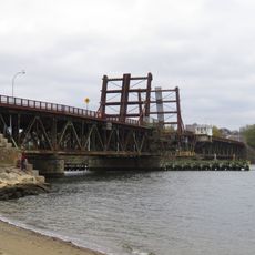
Veterans Memorial Bridge, Bascule bridge in Somerset and Fall River, Massachusetts, US

Description

Veterans Memorial Bridge is a bascule bridge spanning the Taunton River between Somerset and Fall River while carrying U.S. Route 6 and Route 138. It includes a wide bike path on its north side with connecting ramps providing access to Route 79.

History

Construction began in 2007 as part of broader regional infrastructure planning and faced initial funding constraints. The bridge opened in 2011 and provided a new crossing for vehicular and bicycle traffic between the two towns.

Culture

The bridge honors veterans through its name and serves as a daily passage for commuters crossing between Somerset and Fall River. A dedicated bike path on the north side reflects the community's investment in alternative transportation options.

Practical

Best accessed via U.S. Route 6 or Route 138, with the bike path offering a safe option for cyclists during any weather. The bridge experiences heavier use during rush hours, and the path can become crowded on pleasant days.

Did you know?

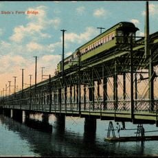
The shipping channel beneath this span accommodates larger vessels than the earlier neighboring bridge, allowing commercial traffic to pass with greater ease. This expanded waterway clearance was a key reason for the project and sets it apart from the older crossing.

Location
Official opening
October 11, 2011
GPS coordinates
41.72640,-71.15170
Latest update
December 12, 2025 17:46

AroundUs brings together thousands of curated places, local tips, and hidden gems, enriched daily by 60,000 contributors worldwide. Discover all places nearby (Massachusetts).

Around this place
B.M.C. Durfee High School
United States of America

B.M.C. Durfee High School

2.3 km
Slade's Ferry Bridge
United States of America

Slade's Ferry Bridge

847 m
Brightman Street Bridge
United States of America

Brightman Street Bridge

426 m
Highlands Historic District
United States of America

Highlands Historic District

1.8 km
Children's Home
United States of America

Children's Home

1.4 km
Osborn House
United States of America

Osborn House

2.1 km
St. Joseph's Church
United States of America

St. Joseph's Church

926 m
Border City Mill No. 2
United States of America

Border City Mill No. 2

870 m
Sagamore Mills No. 1 and No. 3
United States of America

Sagamore Mills No. 1 and No. 3

537 m
Mechanics Mill
United States of America

Mechanics Mill

933 m
Bristol County Superior Court
United States of America

Bristol County Superior Court

2.1 km
David M. Anthony House
United States of America

David M. Anthony House

1.3 km
Ashley House
United States of America

Ashley House

2.3 km
Barnabus Blossom House
United States of America

Barnabus Blossom House

1.2 km
William Lindsey House
United States of America

William Lindsey House

1.1 km
Borden-Winslow House
United States of America

Borden-Winslow House

1.5 km
Unitarian Society
United States of America

Unitarian Society

2.3 km
Sagamore Mill No. 2
United States of America

Sagamore Mill No. 2

685 m
John M. Earle House
United States of America

John M. Earle House

1.2 km
Barnard's Folly
United States of America

Barnard's Folly

983 m
Foster Spinning Co.
United States of America

Foster Spinning Co.

467 m
Hathaway Brightman House
United States of America

Hathaway Brightman House

1.3 km
William Collins House
United States of America

William Collins House

2.3 km
William C. Davol, Jr., House
United States of America

William C. Davol, Jr., House

1.4 km
Squire William B. Canedy House
United States of America

Squire William B. Canedy House

1.9 km
John Mace Smith House
United States of America

John Mace Smith House

1.2 km
James D. Hathaway House
United States of America

James D. Hathaway House

1.5 km
Nathan Read House
United States of America

Nathan Read House

983 m
Show the full map
« Veterans Memorial Bridge - Bascule bridge in Somerset and Fall River, Massachusetts, US » is provided by Around Us (aroundus.com). Images and texts are derived from Wikimedia project under a Creative Commons license. You are allowed to copy, distribute, and modify copies of this page, under the conditions set by the license, as long as this note is clearly visible.

Discover hidden gems everywhere you go!

From secret cafés to breathtaking viewpoints, skip the crowded tourist spots and find places that match your style. Our app makes it easy with voice search, smart filtering, route optimization, and insider tips from travelers worldwide. Download now for the complete mobile experience.

Around Us App Screenshot

A unique approach to discovering new places

Le Figaro

All the places worth exploring

France Info

A tailor-made excursion in just a few clicks

20 Minutes

Around Us
Travel Guide & Maps
Download

Send to your phone

QR Code
1

Open the camera app on your mobile.

2

Point at the QR code with your camera. A notification will appear.

3

Tap the notification to open the link.