Enable Location

We need your location to show you interesting places around you

Discover nearby places

Find interesting locations and hidden gems around you

Precise directions

Get accurate directions and distances to places

Your location is never shared with other users. It's only used when you tap the location button.

Stratford Shoal Light

Log in to your account

Start exploring — it's free

Trusted by 65,719 travelers worldwide

Continue with Google
Continue with Apple
or

We will send you a code to connect

By continuing, you accept our Terms and Conditions and our Privacy Policy

Check your inbox

We've sent a pincode in your inbox. Please enter the code below.

Discussion Reviews 1 Photos
3.9k Popularity

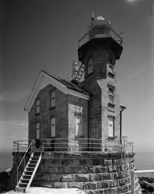
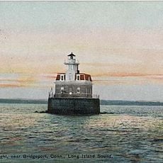
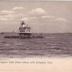
Stratford Shoal Light, Lighthouse in Long Island Sound, Connecticut.

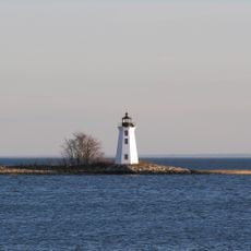
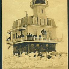
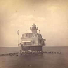
Stratford Shoal Light is a lighthouse built on an artificial island in Long Island Sound, roughly between Port Jefferson on the New York side and Bridgeport on the Connecticut shore. The tower is octagonal, made of granite, and painted white with a red band near its base.

Congress approved the construction in 1877 after a lightship that had been stationed on the shoal kept drifting from its position. The fixed tower replaced it and gave vessels a stable reference point on one of the busiest stretches of water on the East Coast.

This lighthouse represents an important moment in American maritime safety, showing how shipping routes were managed in the 1800s. Visitors who see it from the water can understand why such structures were essential for protecting merchant vessels traveling between major ports.

The lighthouse can only be seen from the water, as there is no public access to the artificial island. Ferries crossing the Long Island Sound and boat tours departing from nearby harbors pass close enough to get a clear view.

The tower was assembled from prefabricated cast iron sections made on land and then brought to the site by boat. This method was rare at the time and allowed workers to build a solid structure on a spot that is surrounded by open water in all directions.

The community of curious travelers

AroundUs brings together thousands of curated places, local tips, and hidden gems, enriched daily by 60,000 contributors worldwide.

Start exploring
Location
Inception
1837
Height
11 m
GPS coordinates
41.05981,-73.10131
Latest update
March 3, 2026 14:04
Around this place
Cedar Beach
United States of America

Cedar Beach

12.2 km
Seaside Park
United States of America

Seaside Park

13.9 km
Brewster House
United States of America

Brewster House

12.8 km
Penfield Reef Light
United States of America

Penfield Reef Light

11.9 km
Seaside Village Historic District
United States of America

Seaside Village Historic District

13.8 km
Mary and Eliza Freeman Houses
United States of America

Mary and Eliza Freeman Houses

14.2 km
Black Rock Harbor Light
United States of America

Black Rock Harbor Light

13.4 km
Old Field Point Light
United States of America

Old Field Point Light

9.3 km
United States of America

Charles E. Wheeler Wildlife Management Area

13.5 km
Bridgeport Harbor Light
United States of America

Bridgeport Harbor Light

12.6 km
Stratford Point Light
United States of America

Stratford Point Light

10.2 km
Frank Melville Memorial Park
United States of America

Frank Melville Memorial Park

12.7 km
Tongue Point Light
United States of America

Tongue Point Light

13.5 km
Bethel-Christian Avenue-Laurel Hill Historical District
United States of America

Bethel-Christian Avenue-Laurel Hill Historical District

13.2 km
Statue of Christopher Columbus
United States of America

Statue of Christopher Columbus

13.3 km
Thompson House
United States of America

Thompson House

14.2 km
Sherwood-Jayne House
United States of America

Sherwood-Jayne House

13.5 km
Perry Memorial Arch
United States of America

Perry Memorial Arch

13.6 km
Samuel Hopkins House
United States of America

Samuel Hopkins House

13.2 km
First National Bank of Port Jefferson
United States of America

First National Bank of Port Jefferson

13 km
Miller Place Historic District
United States of America

Miller Place Historic District

14.2 km
Eagle's Nest
United States of America

Eagle's Nest

14.1 km
Port Jefferson Village Historic District
United States of America

Port Jefferson Village Historic District

12.9 km
Milford Point Hotel
United States of America

Milford Point Hotel

12.9 km
Barnum/Palliser Historic District
United States of America

Barnum/Palliser Historic District

13.9 km
Bridgeport Harbor Light
United States of America

Bridgeport Harbor Light

12.6 km
Emma S. Clark Memorial Library
United States of America

Emma S. Clark Memorial Library

12.8 km
Bridgeport Harbor Light
United States of America

Bridgeport Harbor Light

12.6 km
Show the full map
Reviews
Share your experience

No review yet

Discussions
Start a discussion...

No discussion yet

« Stratford Shoal Light - Lighthouse in Long Island Sound, Connecticut » is provided by Around Us (aroundus.com). Images and texts are derived from Wikimedia project under a Creative Commons license. You are allowed to copy, distribute, and modify copies of this page, under the conditions set by the license, as long as this note is clearly visible.

Discover hidden gems everywhere you go!

From secret cafés to breathtaking viewpoints, skip the crowded tourist spots and find places that match your style. Our app makes it easy with voice search, smart filtering, route optimization, and insider tips from travelers worldwide. Download now for the complete mobile experience.

Around Us App Screenshot

A unique approach to discovering new places

Le Figaro

All the places worth exploring

France Info

A tailor-made excursion in just a few clicks

20 Minutes

Around Us
Travel Guide & Maps
Download

Send to your phone

QR Code
1

Open the camera app on your mobile.

2

Point at the QR code with your camera. A notification will appear.

3

Tap the notification to open the link.