Enable Location

We need your location to show you interesting places around you

Discover nearby places

Find interesting locations and hidden gems around you

Precise directions

Get accurate directions and distances to places

Your location is never shared with other users. It's only used when you tap the location button.

Log in to your account

Start exploring — it's free

Trusted by 62,174 travelers worldwide

Continue with Google
Continue with Apple
or

We will send you a code to connect

By continuing, you accept our Terms and Conditions and our Privacy Policy

Check your inbox

We've sent a pincode in your inbox. Please enter the code below.

Ten Mile Creek State Fish and Wildlife Area

Ten Mile Creek State Fish and Wildlife Area, Protected wildlife area in Hamilton County, Illinois

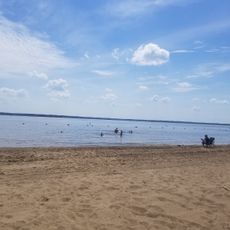
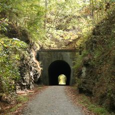
Ten Mile Creek State Fish and Wildlife Area is a protected wildlife area in Hamilton and Jefferson Counties in southern Illinois with forests, wetlands, and open fields. The site contains strip-pit lakes for fishing, designated hiking trails, and zones for archery and target shooting.

The Illinois Department of Natural Resources established this protected area in 1988 to maintain ecological balance and provide outdoor recreation opportunities. The site developed from transformed landscapes into a managed sanctuary where wildlife and human use coexist.

Fishing and hunting are central to how people use this land, with visitors coming to cast lines in the lakes or pursue waterfowl and small game during seasons. The trails and open areas reflect a working landscape where wildlife management and recreation go hand in hand.

Access to the area comes by way of rural roads connecting to Illinois Route 142 and Route 14, with the main entrance located at State Highway 14 near McLeansboro. Visitors should prepare for rural conditions and seasonal timing, as activities are tied to hunting and fishing seasons and weather patterns.

The area maintains about 1,000 acres of planted food sources to support local wildlife populations in a deliberate management strategy. This intentional cultivation sets it apart from many other protected lands where nature is left to its own course.

The community of curious travelers

AroundUs brings together thousands of curated places, local tips, and hidden gems, enriched daily by 60,000 contributors worldwide.

Start exploring
Location
Inception
1988
GPS coordinates
38.10000,-88.62000
Latest update
December 14, 2025 13:08
Around this place
Rend Lake
United States of America

Rend Lake

30 km
Tunnel Hill State Trail
United States of America

Tunnel Hill State Trail

36 km
Franklin County Jail
United States of America

Franklin County Jail

28.1 km
5th District Appellate Court
United States of America

5th District Appellate Court

34.6 km
Cedarhurst Center for the Arts
United States of America

Cedarhurst Center for the Arts

36.6 km
Saline County Poor Farm
United States of America

Saline County Poor Farm

42.7 km
Sesser Opera House
United States of America

Sesser Opera House

37.7 km
Hamilton County Courthouse
United States of America

Hamilton County Courthouse

7.4 km
C. H. Judd House
United States of America

C. H. Judd House

18.1 km
Cloud State Bank
United States of America

Cloud State Bank

7.4 km
Aaron G. Cloud House
United States of America

Aaron G. Cloud House

7.4 km
West Frankfort City Hall
United States of America

West Frankfort City Hall

34.8 km
Goddard Chapel
United States of America

Goddard Chapel

48.2 km
Saline County Courthouse
United States of America

Saline County Courthouse

40.8 km
Old Morrison Mill
United States of America

Old Morrison Mill

35.8 km
Williamson County Courthouse
United States of America

Williamson County Courthouse

49.1 km
Mulkeytown Christian Church
United States of America

Mulkeytown Christian Church

45.5 km
Wayne County Courthouse
United States of America

Wayne County Courthouse

38.7 km
Eldorado City Hall
United States of America

Eldorado City Hall

35.6 km
James Robert Williams House
United States of America

James Robert Williams House

40.5 km
Chalon Guard and Emma Blades Cloud House
United States of America

Chalon Guard and Emma Blades Cloud House

7.4 km
Harrisburg City Hall
United States of America

Harrisburg City Hall

40.8 km
Robinson-Stewart House
United States of America

Robinson-Stewart House

40.4 km
Franklin County Courthouse
United States of America

Franklin County Courthouse

28.7 km
Turney-Hall House
United States of America

Turney-Hall House

38.2 km
West Franklin Historical Museum
United States of America

West Franklin Historical Museum

45.6 km
Carmi Chapter House
United States of America

Carmi Chapter House

39.6 km
G.J. George House
United States of America

G.J. George House

38.2 km
Show the full map
« Ten Mile Creek State Fish and Wildlife Area - Protected wildlife area in Hamilton County, Illinois » is provided by Around Us (aroundus.com). Images and texts are derived from Wikimedia project under a Creative Commons license. You are allowed to copy, distribute, and modify copies of this page, under the conditions set by the license, as long as this note is clearly visible.

Discover hidden gems everywhere you go!

From secret cafés to breathtaking viewpoints, skip the crowded tourist spots and find places that match your style. Our app makes it easy with voice search, smart filtering, route optimization, and insider tips from travelers worldwide. Download now for the complete mobile experience.

Around Us App Screenshot

A unique approach to discovering new places

Le Figaro

All the places worth exploring

France Info

A tailor-made excursion in just a few clicks

20 Minutes

Around Us
Travel Guide & Maps
Download

Send to your phone

QR Code
1

Open the camera app on your mobile.

2

Point at the QR code with your camera. A notification will appear.

3

Tap the notification to open the link.