Chest opened
+${chestReward.xp} XP
Explorer
NOUVEAU ×${chestReward.collectible.quantity}
tapez pour fermer
Chest locked

Open chests in the app

Around Us is built for your phone — chests unlock when you walk, explore and capture nearby places.

Enable Location

We need your location to show you interesting places around you

Discover nearby places

Find interesting locations and hidden gems around you

Precise directions

Get accurate directions and distances to places

Your location is never shared with other users. It's only used when you tap the location button.

Log in to your account

Start exploring — it's free

Trusted by 72,887 travelers worldwide

Continue with Google
Continue with Apple
or

We will send you a code to connect

By continuing, you accept our Terms and Conditions and our Privacy Policy

Check your inbox

We've sent a pincode in your inbox. Please enter the code below.

Tamarac Wilderness
Discussion Reviews Photo
1.4k Popularity

Tamarac Wilderness, Wilderness area in Becker County, United States.

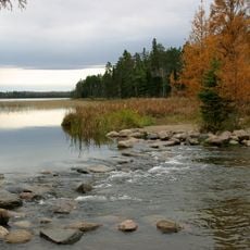
Tamarac Wilderness is a protected forest area in northwestern Minnesota covering about 2,180 acres (880 hectares). The landscape contains small lakes, wooded depressions, bogs, and marshes that form part of the Tamarac National Wildlife Refuge.

The area served as hunting and fishing ground for Sioux and Ojibwe people for centuries. The U.S. Congress officially designated it as wilderness in 1976 to preserve this landscape.

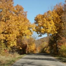
The forest character defines the place through its appearance and how people move through it. The mix of tree species creates a visible transition between eastern hardwoods and northern conifers as you walk the trails.

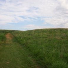
You reach the area through county roads and can explore marked trails like the Discovery Center Trail and Pine Lake Loop. The paths are well-marked so navigation is straightforward.

The area is known for nesting trumpeter swans, a relatively uncommon sight in the region. Large predators like black bears, timber wolves, and otters also live here, making the forest an important refuge for these animals.

The community of curious travelers

AroundUs brings together thousands of curated places, local tips, and hidden gems, enriched daily by 60,000 contributors worldwide.

Start exploring
Location
GPS coordinates
47.07080,-95.59530
Latest update
December 14, 2025 16:42
Around this place
Paul Bunyan and Babe the Blue Ox
United States of America

Paul Bunyan and Babe the Blue Ox

70.1 km
Itasca State Park
United States of America

Itasca State Park

34.9 km
Maplewood State Park
United States of America

Maplewood State Park

65.6 km
Buffalo River State Park
United States of America

Buffalo River State Park

69.6 km
Tamarac National Wildlife Refuge
United States of America

Tamarac National Wildlife Refuge

3.3 km
Pelican Pete
United States of America

Pelican Pete

67 km
Paul Bunyan State Forest
United States of America

Paul Bunyan State Forest

45 km
Hamden Slough National Wildlife Refuge
United States of America

Hamden Slough National Wildlife Refuge

37.7 km
Nevis Tiger Muskie
United States of America

Nevis Tiger Muskie

58.4 km
Bemidji Carnegie Library
United States of America

Bemidji Carnegie Library

70.2 km
Beltrami County Courthouse
United States of America

Beltrami County Courthouse

70.1 km
O.A.E. Blyberg House
United States of America

O.A.E. Blyberg House

67.6 km
Mahnomen County Courthouse
United States of America

Mahnomen County Courthouse

39.5 km
Nymore Bridge
United States of America

Nymore Bridge

69.8 km
Gran Evangelical Lutheran Church
United States of America

Gran Evangelical Lutheran Church

53.3 km
Hubbard County Courthouse
United States of America

Hubbard County Courthouse

43.7 km
People's Union Church
United States of America

People's Union Church

57.6 km
White Earth State Forest
United States of America

White Earth State Forest

42.2 km
Smoky Hills State Forest
United States of America

Smoky Hills State Forest

21.1 km
Buffalo River State Park WPA/Rustic Style Historic Resources
United States of America

Buffalo River State Park WPA/Rustic Style Historic Resources

70.3 km
Aiton Heights Fire Tower
United States of America

Aiton Heights Fire Tower

33.4 km
Detroit Lakes City Park
United States of America

Detroit Lakes City Park

21.6 km
Height of Land Lookout Tower
United States of America

Height of Land Lookout Tower

19.2 km
Schoolcraft Fire Tower
United States of America

Schoolcraft Fire Tower

55.8 km
Badoura Lookout Tower
United States of America

Badoura Lookout Tower

70.2 km
Smoky Hills Lookout Tower
United States of America

Smoky Hills Lookout Tower

23.8 km
Kabekona Lookout Tower
United States of America

Kabekona Lookout Tower

56.7 km
Recreation Building
United States of America

Recreation Building

34.8 km
Show the full map
Reviews
Share your experience

No review yet

Discussions
Start a discussion...

No discussion yet

« Tamarac Wilderness - Wilderness area in Becker County, United States » is provided by Around Us (aroundus.com). Images and texts are derived from Wikimedia project under a Creative Commons license. You are allowed to copy, distribute, and modify copies of this page, under the conditions set by the license, as long as this note is clearly visible.

Discover hidden gems everywhere you go!

From secret cafés to breathtaking viewpoints, skip the crowded tourist spots and find places that match your style. Our app makes it easy with voice search, smart filtering, route optimization, and insider tips from travelers worldwide. Download now for the complete mobile experience.

Around Us App Screenshot

A unique approach to discovering new places

Le Figaro

All the places worth exploring

France Info

A tailor-made excursion in just a few clicks

20 Minutes

Around Us
Travel Guide & Maps
Download

Send to your phone

QR Code
1

Open the camera app on your mobile.

2

Point at the QR code with your camera. A notification will appear.

3

Tap the notification to open the link.