Enable Location

We need your location to show you interesting places around you

Discover nearby places

Find interesting locations and hidden gems around you

Precise directions

Get accurate directions and distances to places

Your location is never shared with other users. It's only used when you tap the location button.

Toolesboro Mound Group

Log in to your account

Start exploring — it's free

Trusted by 62,169 travelers worldwide

Continue with Google
Continue with Apple
or

We will send you a code to connect

By continuing, you accept our Terms and Conditions and our Privacy Policy

Check your inbox

We've sent a pincode in your inbox. Please enter the code below.

Toolesboro Mound Group, Archaeological burial mounds in Wapello, United States

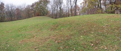
Toolesboro Mound Group comprises seven cone-shaped earthen mounds positioned on a bluff where the Iowa and Mississippi Rivers converge. These structures were built as burial monuments and overlook the river valley below.

Hopewell communities built these mounds between 200 BCE and 300 CE, making them among the earliest monumental structures in the region. Their construction reflects a period of cultural development and stable settlement.

Excavated items from this site reveal far-reaching trade connections, with copper from the Great Lakes and shells from distant southern waters showing how communities exchanged goods across the continent.

The site is best explored at a leisurely pace, allowing time to walk around each mound and take in views from the higher elevations. The terrain is uneven, so comfortable walking shoes and enough time to wander are helpful for a full experience.

One of the seven mounds stands distinctly larger than the others, marking it as a notable example of Hopewell construction methods. This particular mound likely served as a burial place for a person of high importance.

The community of curious travelers

AroundUs brings together thousands of curated places, local tips, and hidden gems, enriched daily by 60,000 contributors worldwide.

Start exploring
Location
GPS coordinates
41.15000,-91.05000
Latest update
December 12, 2025 07:56
Around this place
Norbert F. Beckey Bridge
United States of America

Norbert F. Beckey Bridge

30.4 km
Lock and Dam No. 18
United States of America

Lock and Dam No. 18

29.9 km
Lock and Dam No. 17
United States of America

Lock and Dam No. 17

4.6 km
Keithsburg Rail Bridge
United States of America

Keithsburg Rail Bridge

9.6 km
Alexander Clark House
United States of America

Alexander Clark House

30.2 km
Oquawka Wagon Bridge
United States of America

Oquawka Wagon Bridge

29.7 km
Mercer County Courthouse
United States of America

Mercer County Courthouse

25.8 km
Pliny and Adelia Fay House
United States of America

Pliny and Adelia Fay House

29.8 km
Louisa County Courthouse
United States of America

Louisa County Courthouse

11.8 km
Alexis Phelps House
United States of America

Alexis Phelps House

24.8 km
Clark-Blackwell House
United States of America

Clark-Blackwell House

29.7 km
Hawkeye Creek Bridge
United States of America

Hawkeye Creek Bridge

12 km
Hotel Wapello
United States of America

Hotel Wapello

12 km
Levi Willits House
United States of America

Levi Willits House

4.7 km
Bethel Church
United States of America

Bethel Church

12.3 km
Community Building
United States of America

Community Building

29.6 km
West Hill Historic District
United States of America

West Hill Historic District

30 km
Greenwood Cemetery Chapel
United States of America

Greenwood Cemetery Chapel

30.1 km
Baptist Church
United States of America

Baptist Church

24.7 km
Welch Apartments
United States of America

Welch Apartments

30.2 km
Henderson County Courthouse
United States of America

Henderson County Courthouse

25.2 km
James S. Thompson House
United States of America

James S. Thompson House

5.3 km
J. C. B. Warde House
United States of America

J. C. B. Warde House

29.7 km
Florence-Council On The Iowa Site
United States of America

Florence-Council On The Iowa Site

7.2 km
S. M. McKibben House
United States of America

S. M. McKibben House

30.3 km
Commercial House
United States of America

Commercial House

10.6 km
Gideon Ives House
United States of America

Gideon Ives House

5.2 km
Pearl Bottom Museum
United States of America

Pearl Bottom Museum

30.2 km
Show the full map
« Toolesboro Mound Group - Archaeological burial mounds in Wapello, United States » is provided by Around Us (aroundus.com). Images and texts are derived from Wikimedia project under a Creative Commons license. You are allowed to copy, distribute, and modify copies of this page, under the conditions set by the license, as long as this note is clearly visible.

Discover hidden gems everywhere you go!

From secret cafés to breathtaking viewpoints, skip the crowded tourist spots and find places that match your style. Our app makes it easy with voice search, smart filtering, route optimization, and insider tips from travelers worldwide. Download now for the complete mobile experience.

Around Us App Screenshot

A unique approach to discovering new places

Le Figaro

All the places worth exploring

France Info

A tailor-made excursion in just a few clicks

20 Minutes

Around Us
Travel Guide & Maps
Download

Send to your phone

QR Code
1

Open the camera app on your mobile.

2

Point at the QR code with your camera. A notification will appear.

3

Tap the notification to open the link.