·

Enable Location

We need your location to show you interesting places around you

Discover nearby places

Find interesting locations and hidden gems around you

Precise directions

Get accurate directions and distances to places

Your location is never shared with other users. It's only used when you tap the location button.

Tulip Viaduct

Log in to your account

Start exploring — it's free

Trusted by 62,698 travelers worldwide

Continue with Google
Continue with Apple
or

We will send you a code to connect

By continuing, you accept our Terms and Conditions and our Privacy Policy

Check your inbox

We've sent a pincode in your inbox. Please enter the code below.

Tulip Viaduct

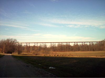
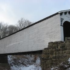
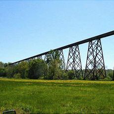
Tulip Viaduct, Railway bridge in Greene County, Indiana, United States.

Tulip Viaduct is a railway bridge that spans across Richland Creek valley in Greene County, supported by tall steel towers. The structure connects two sections of land and continues to carry train traffic over the valley today.

The bridge was built between 1905 and 1906 and was one of the longest railway structures of its time worldwide. Its construction represented an important advance in railroad engineering and opened new transportation connections in the region.

Italian immigrant workers built this engineering structure, earning 30 cents per hour while contributing to American railroad infrastructure development.

The viaduct is visible from nearby roads and offers viewing points in the surrounding area where visitors can observe the structure from below. You best experience the scale of the structure from the surrounding hills, where you have a clear view of its full span.

The viaduct was built using a construction technique that allowed engineers to bridge such a long span without central supports in the middle section. This method demonstrated how engineers of that era pushed the boundaries of what was possible.

The community of curious travelers

AroundUs brings together thousands of curated places, local tips, and hidden gems, enriched daily by 60,000 contributors worldwide.

Start exploring
Location
Length
700 m
GPS coordinates
39.07530,-86.85520
Latest update
December 8, 2025 20:00
Around this place
McCormick's Creek State Park
United States of America

McCormick's Creek State Park

26.8 km
Elias Abel House
United States of America

Elias Abel House

29 km
Owen County Courthouse
United States of America

Owen County Courthouse

22.9 km
Second Baptist Church
United States of America

Second Baptist Church

29.2 km
David Enoch Beem House
United States of America

David Enoch Beem House

25.1 km
Ennis Archaeological Site
United States of America

Ennis Archaeological Site

23.4 km
McCormick's Creek State Park Entrance and Gatehouse
United States of America

McCormick's Creek State Park Entrance and Gatehouse

25.8 km
Richland-Plummer Creek Covered Bridge
United States of America

Richland-Plummer Creek Covered Bridge

11.6 km
Steele Dunning Historic District
United States of America

Steele Dunning Historic District

29 km
Greene County Courthouse
United States of America

Greene County Courthouse

9 km
Joseph Mitchell House
United States of America

Joseph Mitchell House

26.4 km
Allison-Robinson House
United States of America

Allison-Robinson House

24.8 km
Prospect Hill Historic District
United States of America

Prospect Hill Historic District

29 km
Stone Arch Bridge over McCormick's Creek
United States of America

Stone Arch Bridge over McCormick's Creek

26.7 km
Spencer Public Library
United States of America

Spencer Public Library

24.7 km
Tide Water Pumping Station
United States of America

Tide Water Pumping Station

26.4 km
CCC Recreation Building-Nature Museum
United States of America

CCC Recreation Building-Nature Museum

26.5 km
Moffett-Ralston House
United States of America

Moffett-Ralston House

28.4 km
Blair-Dunning House
United States of America

Blair-Dunning House

29 km
Linton Public Library Building
United States of America

Linton Public Library Building

27.2 km
John F. and Malissa Koontz House
United States of America

John F. and Malissa Koontz House

19.8 km
Matthews Stone Company Historic District
United States of America

Matthews Stone Company Historic District

27.8 km
Ellettsville Downtown Historic District
United States of America

Ellettsville Downtown Historic District

26.9 km
Linton Commercial Historic District
United States of America

Linton Commercial Historic District

27.3 km
Leroy Mayfield House
United States of America

Leroy Mayfield House

22.8 km
Tulip Trestle
United States of America

Tulip Trestle

105 m
Karst Farm Park splash pad
United States of America

Karst Farm Park splash pad

22.9 km
Ketcham Travis House
United States of America

Ketcham Travis House

24.9 km
Show the full map
« Tulip Viaduct - Railway bridge in Greene County, Indiana, United States » is provided by Around Us (aroundus.com). Images and texts are derived from Wikimedia project under a Creative Commons license. You are allowed to copy, distribute, and modify copies of this page, under the conditions set by the license, as long as this note is clearly visible.

Discover hidden gems everywhere you go!

From secret cafés to breathtaking viewpoints, skip the crowded tourist spots and find places that match your style. Our app makes it easy with voice search, smart filtering, route optimization, and insider tips from travelers worldwide. Download now for the complete mobile experience.

Around Us App Screenshot

A unique approach to discovering new places

Le Figaro

All the places worth exploring

France Info

A tailor-made excursion in just a few clicks

20 Minutes

Around Us
Travel Guide & Maps
Download

Send to your phone

QR Code
1

Open the camera app on your mobile.

2

Point at the QR code with your camera. A notification will appear.

3

Tap the notification to open the link.