Waters Farm

Log in to your account

AroundUs is a community-driven map of interesting places, built by curious explorers like you. It grows with every review, story, and photo you share.
Connect to save your favorite spots, contribute locations, and create personalized routes.
Continue with Google
Continue with Apple
Continue with X
Continue with Facebook
Continue with email
By continuing, you accept our Terms and Conditions and our Privacy Policy
Create an account
Add to collection
Map
Suggest a change
Share

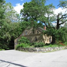
Waters Farm, Historical farm museum in Sutton, Massachusetts, United States.

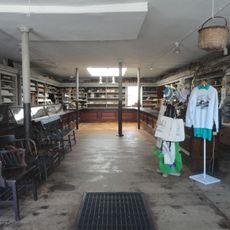
Waters Farm is a working museum property spanning 120 acres of protected land with several historic structures including a blacksmith shop, shingle mill, barn, and wagon shed arranged across the property. The buildings represent different functions needed to run a complete farm operation in the 1700s and 1800s.

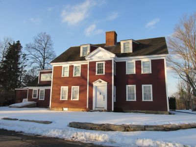
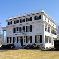
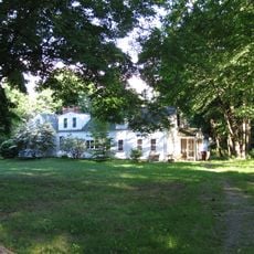
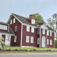
Stephen Waters established this farm property in 1757 with Georgian-style architecture, and it gained official recognition on the National Register of Historic Places in 1985. The designation reflects its importance in preserving the story of farmstead life in early Massachusetts.

The farm demonstrates rural crafts and daily work methods that shaped life in the region for generations, with hands-on exhibits showing how people managed agriculture and household tasks. Walking through the buildings reveals the practical skills and knowledge that families relied on to survive and thrive on the land.

The property is located on Waters Road in Sutton and is best explored on dry days when all paths and buildings are easily accessible throughout the grounds. Good walking shoes are helpful since the terrain is somewhat hilly with some unpaved paths between the structures.

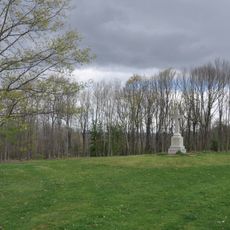
The hilltop setting offers views toward Lake Manchaug and reflects how early settlers chose locations that provided water access, sightlines, and natural protection. The lake was vital to the community as a resource for powering mills and supporting daily life.

Location: Massachusetts

GPS coordinates: 42.10583,-71.78389

Latest update: December 14, 2025 12:24

Photos
Around this place
Purgatory Chasm State Reservation
United States of America

Purgatory Chasm State Reservation

6.3 km
Douglas State Forest
United States of America

Douglas State Forest

8.2 km
Huguenot Fort
United States of America

Huguenot Fort

5.3 km
Asa Waters Mansion
United States of America

Asa Waters Mansion

9.6 km
Manchaug Village Historic District
United States of America

Manchaug Village Historic District

3.3 km
St. Joseph Basilica
United States of America

St. Joseph Basilica

9.7 km
Hudson House
United States of America

Hudson House

6 km
Bartlett's Bridge
United States of America

Bartlett's Bridge

9.8 km
Civil War Memorial
United States of America

Civil War Memorial

10.1 km
E. N. Jenckes Store
United States of America

E. N. Jenckes Store

6.9 km
Joseph Stone House
United States of America

Joseph Stone House

9.7 km
Simon Fairfield Public Library
United States of America

Simon Fairfield Public Library

6.9 km
Thompson School
United States of America

Thompson School

9.9 km
Whitinsville Historic District
United States of America

Whitinsville Historic District

9.7 km
Hayward Mill
United States of America

Hayward Mill

6.9 km
Freegrace Marble Farm Historic District
United States of America

Freegrace Marble Farm Historic District

6.9 km
Old Douglas Center Historic District
United States of America

Old Douglas Center Historic District

6.8 km
A. Whipple House
United States of America

A. Whipple House

8.9 km
N. Williams House
United States of America

N. Williams House

9 km
Sutton Center Historic District
United States of America

Sutton Center Historic District

5.3 km
Tuttle Square School
United States of America

Tuttle Square School

10.4 km
First Presbyterian Society Meeting House
United States of America

First Presbyterian Society Meeting House

9.8 km
Oxford Main Street Historic District
United States of America

Oxford Main Street Historic District

6.8 km
West Sutton Historic District
United States of America

West Sutton Historic District

2 km
Rock Castle School
United States of America

Rock Castle School

9.7 km
Shumway Block
United States of America

Shumway Block

10.5 km
Main Street Historic District
United States of America

Main Street Historic District

10.3 km
Waters Farm
United States of America

Waters Farm

78 m
Show the full map
Reviews

Visited this place? Tap the stars to rate it and share your experience / photos with the community! Try now! You can cancel it anytime.

« Waters Farm - Historical farm museum in Sutton, Massachusetts, United States » is provided by Around Us (aroundus.com). Images and texts are derived from Wikimedia project under a Creative Commons license. You are allowed to copy, distribute, and modify copies of this page, under the conditions set by the license, as long as this note is clearly visible.

Discover hidden gems everywhere you go!

From secret cafés to breathtaking viewpoints, skip the crowded tourist spots and find places that match your style. Our app makes it easy with voice search, smart filtering, route optimization, and insider tips from travelers worldwide. Download now for the complete mobile experience.

Around Us App Screenshot

A unique approach to discovering new places

Le Figaro

All the places worth exploring

France Info

A tailor-made excursion in just a few clicks

20 Minutes