Enable Location

We need your location to show you interesting places around you

Discover nearby places

Find interesting locations and hidden gems around you

Precise directions

Get accurate directions and distances to places

Your location is never shared with other users. It's only used when you tap the location button.

Mount Hope Cemetery

Log in to your account

Start exploring — it's free

Trusted by 62,572 travelers worldwide

Continue with Google
Continue with Apple
or

We will send you a code to connect

By continuing, you accept our Terms and Conditions and our Privacy Policy

Check your inbox

We've sent a pincode in your inbox. Please enter the code below.

Mount Hope Cemetery, cemetery in Boston, Massachusetts

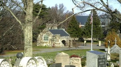
Mount Hope Cemetery is a 125-acre active burial ground in Boston founded in 1852 and purchased by the city in 1857. The grounds contain historic sections in 19th-century style alongside modern areas, including a dedicated section for military veterans.

The cemetery was established in 1852 when Boston's older burial grounds became overcrowded and posed health concerns. The city took over management in 1857, adopting the garden cemetery style that was popular at the time, with winding paths and planted trees.

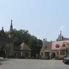
The cemetery reflects Boston's diversity through sections dedicated to different ethnic groups, veterans organizations, and local fraternal societies. These varied areas show how different communities have been woven into the fabric of the city over time.

The cemetery is located on Walk Hill Street in the Roslindale and Mattapan neighborhoods and opens daily, with shorter hours during colder months. Visitors should note that the office is staffed on weekdays and some Saturdays, and maps are available at the entrance or online.

A section of the cemetery known as Cypress Vale was used for burying the city's poor and functioned as a Potter's Field, a designated area for those who could not afford marked graves. This overlooked section tells an important story about the less visible people in Boston's history.

The community of curious travelers

AroundUs brings together thousands of curated places, local tips, and hidden gems, enriched daily by 60,000 contributors worldwide.

Start exploring
Location
GPS coordinates
42.28378,-71.10261
Latest update
February 9, 2026 08:21
Around this place
Arnold Arboretum
United States of America

Arnold Arboretum

2.3 km
Franklin Park Zoo
United States of America

Franklin Park Zoo

2.6 km
Forest Hills Cemetery
United States of America

Forest Hills Cemetery

1.2 km
Franklin Park
United States of America

Franklin Park

2.1 km
George Wright Golf Course
United States of America

George Wright Golf Course

3 km
Codman Square District
United States of America

Codman Square District

2.7 km
Death and the Sculptor
United States of America

Death and the Sculptor

1.6 km
Firemen's Memorial
United States of America

Firemen's Memorial

1.1 km
Annunciation Melkite Catholic Cathedral
United States of America

Annunciation Melkite Catholic Cathedral

3 km
Buildings at 825–829 Blue Hill Avenue
United States of America

Buildings at 825–829 Blue Hill Avenue

1.9 km
Truman Parkway
United States of America

Truman Parkway

2.9 km
Loring-Greenough House
United States of America

Loring-Greenough House

3.1 km
First Congregational Church of Hyde Park
United States of America

First Congregational Church of Hyde Park

3.3 km
Almont Apartments
United States of America

Almont Apartments

1.2 km
St. Mark's Episcopal Church
United States of America

St. Mark's Episcopal Church

2.9 km
Home for Destitute Jewish Children
United States of America

Home for Destitute Jewish Children

1.5 km
Eliot Hall
United States of America

Eliot Hall

3.2 km
Sumner Hill Historic District
United States of America

Sumner Hill Historic District

3 km
Roslindale Baptist Church
United States of America

Roslindale Baptist Church

2.1 km
Monument Square Historic District
United States of America

Monument Square Historic District

3.1 km
Sherman Apartments Historic District
United States of America

Sherman Apartments Historic District

2.7 km
Esmond Street Historic District
United States of America

Esmond Street Historic District

2.2 km
Walton and Roslin Halls
United States of America

Walton and Roslin Halls

2.6 km
Samuel Edelman Apartments
United States of America

Samuel Edelman Apartments

2.2 km
Nathan Warnick Apartments
United States of America

Nathan Warnick Apartments

2.3 km
Benjamin Silverman Apartments
United States of America

Benjamin Silverman Apartments

1.5 km
Jamaica Plain Branch Library
United States of America

Jamaica Plain Branch Library

2.9 km
Roslindale Branch Library
United States of America

Roslindale Branch Library

2.1 km
Show the full map
« Mount Hope Cemetery - cemetery in Boston, Massachusetts » is provided by Around Us (aroundus.com). Images and texts are derived from Wikimedia project under a Creative Commons license. You are allowed to copy, distribute, and modify copies of this page, under the conditions set by the license, as long as this note is clearly visible.

Discover hidden gems everywhere you go!

From secret cafés to breathtaking viewpoints, skip the crowded tourist spots and find places that match your style. Our app makes it easy with voice search, smart filtering, route optimization, and insider tips from travelers worldwide. Download now for the complete mobile experience.

Around Us App Screenshot

A unique approach to discovering new places

Le Figaro

All the places worth exploring

France Info

A tailor-made excursion in just a few clicks

20 Minutes

Around Us
Travel Guide & Maps
Download

Send to your phone

QR Code
1

Open the camera app on your mobile.

2

Point at the QR code with your camera. A notification will appear.

3

Tap the notification to open the link.