Mount Bolanos, Mountain peak in Talo'fo'fo' Municipality, Guam
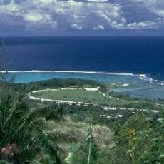
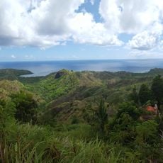
Mount Bolanos is a summit in Talo'fo'fo' Municipality on the island of Guam, rising to about 368 meters (1,207 feet) above sea level. The peak lies between three villages and serves as a natural geographical marker across the southern part of the island.
The peak has been recorded on United States Geological Survey maps for many decades, providing navigation reference for local residents and explorers. Its role as a geographical marker has remained consistent throughout modern Guamanian history.
The mountain functions as a central geographical reference point for local communities, connecting three distinct village territories within the Guamanian landscape.
Bring plenty of water and a map or GPS device when visiting, since the area has no developed trails or facilities. The terrain is undeveloped, so proper preparation and navigation tools are important for a safe visit.
The peak ranks among the island's highest summits and stands out for its prominence in shaping the landscape of southern Guam. Its elevation and location make it one of the more notable geographical features on an island where mountains are relatively rare.
Location: Talo’fo’fo’ Municipality
Elevation above the sea: 368 m
GPS coordinates: 13.29959,144.68753
Latest update: December 14, 2025 11:02
Mount Lamlam
4.8 km
War in the Pacific National Historical Park
2.2 km
Plaza de España
20.6 kmBlue Hole
17.3 km
Japanese midget submarine Ha. 62-76
15 km
Guam Congress Building
20.7 kmPiti Bomb Holes Marine Preserve
19.1 km
Orote Field
16.1 km
Piti Guns
18.1 km
Aratama Maru
9.5 km
Fort Nuestra Señora de la Soledad
3.3 km
Fort Santa Agueda
20.4 km
Asan Invasion Beach
19.4 km
Agana Spanish Bridge
20.6 kmTalofofo Bay
9.6 km
Cetti Bay
4.1 kmUmatac Outdoor Library
2.9 km
Agat Invasion Beach
10.2 km
Taleyfac Spanish Bridge
8.2 km
Guam Cable Station
16 km
Fort Santo Angel
3.4 km
San Dionisio Church Ruins
2.9 km
Sumay Cemetery
15.6 km
Mount Jumullong Manglo
3.7 km
Magellan Monument
2.7 km
Korean Air Flight KE801 1997-Crash Memorial
18 km
Nieves M. Flores Memorial Library
20.6 km
Apolinario Mabini historical marker
19.6 kmVisited this place? Tap the stars to rate it and share your experience / photos with the community! Try now! You can cancel it anytime.
Discover hidden gems everywhere you go!
From secret cafés to breathtaking viewpoints, skip the crowded tourist spots and find places that match your style. Our app makes it easy with voice search, smart filtering, route optimization, and insider tips from travelers worldwide. Download now for the complete mobile experience.
A unique approach to discovering new places❞
— Le Figaro
All the places worth exploring❞
— France Info
A tailor-made excursion in just a few clicks❞
— 20 Minutes