Enable Location

We need your location to show you interesting places around you

Discover nearby places

Find interesting locations and hidden gems around you

Precise directions

Get accurate directions and distances to places

Your location is never shared with other users. It's only used when you tap the location button.

Mount Bethel Baptist Meetinghouse

Log in to your account

Start exploring — it's free

Trusted by 62,408 travelers worldwide

Continue with Google
Continue with Apple
or

We will send you a code to connect

By continuing, you accept our Terms and Conditions and our Privacy Policy

Check your inbox

We've sent a pincode in your inbox. Please enter the code below.

Mount Bethel Baptist Meetinghouse

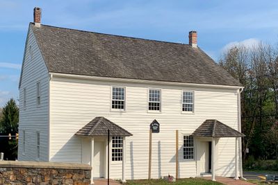
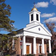
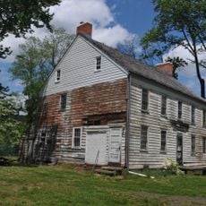
Mount Bethel Baptist Meetinghouse, Baptist meetinghouse in Mount Bethel, United States.

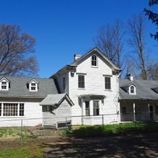
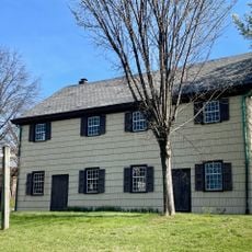
Mount Bethel Baptist Meetinghouse is a Baptist meeting house located at the intersection of County Route 651 and Mountainview Road in Warren Township. The two and one-half story wooden frame building features a straightforward design with no decorative elements, typical of early American religious structures.

The building was constructed in 1786 by Somerset County's first Baptist congregation, incorporating materials from an earlier structure on the site. It received recognition on the National Register of Historic Places in 1976.

The name comes from the biblical Mount Bethel, reflecting the spiritual identity of the early Baptist community that gathered here. Its plain wooden structure shows how worshippers valued simplicity and function over decoration in their prayer space.

The building can be viewed from the outside along the quiet country road where it sits, so arriving by car is practical. The surrounding area is rural with few nearby facilities or services, so plan accordingly for your visit.

The congregation abandoned this original meetinghouse in 1960 when they built a new church building elsewhere in Warren Township. Yet the old structure remained intact and unmodified, demonstrating how early Baptist buildings endure long after their congregations move on.

The community of curious travelers

AroundUs brings together thousands of curated places, local tips, and hidden gems, enriched daily by 60,000 contributors worldwide.

Start exploring
Location
GPS coordinates
40.63810,-74.51470
Latest update
December 14, 2025 18:06
Around this place
Devil's Tree
United States of America

Devil's Tree

5.8 km
Washington Rock State Park
United States of America

Washington Rock State Park

4.5 km
Basking Ridge White Oak Tree
United States of America

Basking Ridge White Oak Tree

8.2 km
Lyons VA Medical Center
United States of America

Lyons VA Medical Center

5 km
Bowlero
United States of America

Bowlero

5.8 km
Lord Stirling Park
United States of America

Lord Stirling Park

6.8 km
Presbyterian Church in Basking Ridge
United States of America

Presbyterian Church in Basking Ridge

8.2 km
Washington Rock State Park
United States of America

Washington Rock State Park

4.6 km
Lord Stirling Manor Site
United States of America

Lord Stirling Manor Site

6.4 km
Brick Academy
United States of America

Brick Academy

8.2 km
Joseph and Minnie White House
United States of America

Joseph and Minnie White House

7.5 km
Presbyterian Church at Bound Brook
United States of America

Presbyterian Church at Bound Brook

8 km
Vermeule Mansion
United States of America

Vermeule Mansion

5.9 km
Green Brook Park
United States of America

Green Brook Park

6.7 km
Kirch-Ford House
United States of America

Kirch-Ford House

1.1 km
Washington Park Historic District
United States of America

Washington Park Historic District

7.1 km
Dr. John Vermeule House
United States of America

Dr. John Vermeule House

5.6 km
Vail-Trust House
United States of America

Vail-Trust House

5.8 km
North Avenue Commercial District
United States of America

North Avenue Commercial District

8.2 km
Kennedy-Martin-Stelle Farmstead
United States of America

Kennedy-Martin-Stelle Farmstead

2.5 km
Littel-Lord Farmstead
United States of America

Littel-Lord Farmstead

8 km
Plainfield Civic District
United States of America

Plainfield Civic District

8.5 km
East County Park
United States of America

East County Park

1.8 km
Buttermilk Falls
United States of America

Buttermilk Falls

6.8 km
Basking Ridge Presbyterian Church Cemetery
United States of America

Basking Ridge Presbyterian Church Cemetery

8.3 km
Chimney Rock Quarry
United States of America

Chimney Rock Quarry

7.3 km
Nathaniel Drake House
United States of America

Nathaniel Drake House

7.5 km
Rahway and Plainfield Friends Meeting House
United States of America

Rahway and Plainfield Friends Meeting House

8.3 km
Show the full map
« Mount Bethel Baptist Meetinghouse - Baptist meetinghouse in Mount Bethel, United States » is provided by Around Us (aroundus.com). Images and texts are derived from Wikimedia project under a Creative Commons license. You are allowed to copy, distribute, and modify copies of this page, under the conditions set by the license, as long as this note is clearly visible.

Discover hidden gems everywhere you go!

From secret cafés to breathtaking viewpoints, skip the crowded tourist spots and find places that match your style. Our app makes it easy with voice search, smart filtering, route optimization, and insider tips from travelers worldwide. Download now for the complete mobile experience.

Around Us App Screenshot

A unique approach to discovering new places

Le Figaro

All the places worth exploring

France Info

A tailor-made excursion in just a few clicks

20 Minutes

Around Us
Travel Guide & Maps
Download

Send to your phone

QR Code
1

Open the camera app on your mobile.

2

Point at the QR code with your camera. A notification will appear.

3

Tap the notification to open the link.