Enable Location

We need your location to show you interesting places around you

Discover nearby places

Find interesting locations and hidden gems around you

Precise directions

Get accurate directions and distances to places

Your location is never shared with other users. It's only used when you tap the location button.

Mount Mourne Plantation

Log in to your account

Start exploring — it's free

Trusted by 62,486 travelers worldwide

Continue with Google
Continue with Apple
or

We will send you a code to connect

By continuing, you accept our Terms and Conditions and our Privacy Policy

Check your inbox

We've sent a pincode in your inbox. Please enter the code below.

Mount Mourne Plantation, human settlement in North Carolina, United States of America

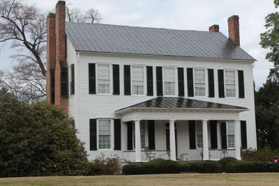
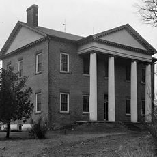
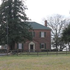
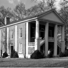
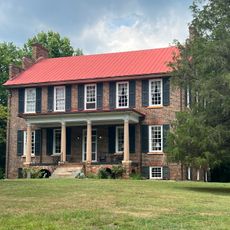
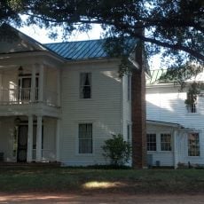
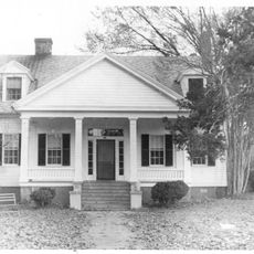
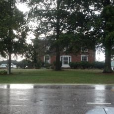
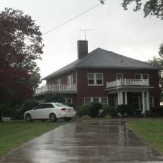
Mount Mourne Plantation is a two-story house built in 1836 in North Carolina that blends Federal and Greek Revival styles, marked by five sections across the front with a sloped roof and entrance porch. The building features four Tuscan columns and sits on roughly 3.6 hectares of land near North Carolina Highway 115.

The house was built in 1836 by Major Rufus Reid, who made it one of the largest plantations in the area and the second largest in Iredell County. The site was added to the National Register of Historic Places in 1974, recognizing its historical importance to the region.

Mount Mourne Plantation takes its name from this historic house and the surrounding community. The site shows how life functioned on large estates in early American history and what role such plantations played in shaping the local region.

The house is now private and not open to visitors, though it remains of interest for exterior viewing and local history walks. Its location near North Carolina Highway 115 makes the site easy to find, even though internal tours are not available.

Under Major Rufus Reid, the plantation was one of the largest in the region and employed nearly 90 workers in fields growing cotton, wheat, and corn. This scale highlights the vast extent of the estate and its economic importance in local history during the early 1800s.

The community of curious travelers

AroundUs brings together thousands of curated places, local tips, and hidden gems, enriched daily by 60,000 contributors worldwide.

Start exploring
Location
GPS coordinates
35.55170,-80.84420
Latest update
February 9, 2026 08:21
Around this place
Lake Norman
United States of America

Lake Norman

11.1 km
United States of America

North Carolina Music Hall of Fame

20.7 km
Lake Norman State Park
United States of America

Lake Norman State Park

15.7 km
Cowans Ford Hydroelectric Station
United States of America

Cowans Ford Hydroelectric Station

16.6 km
Richardson Stadium
United States of America

Richardson Stadium

5.8 km
Beaver Dam Plantation House
United States of America

Beaver Dam Plantation House

8.8 km
A2 wind tunnel
United States of America

A2 wind tunnel

8.6 km
Mooresville Mill Village Historic District
United States of America

Mooresville Mill Village Historic District

3.7 km
Mooresville Historic District
United States of America

Mooresville Historic District

4.5 km
Ingleside
United States of America

Ingleside

20.6 km
Johnson-Neel House
United States of America

Johnson-Neel House

6.2 km
Centre Presbyterian Church, Session House and Cemeteries
United States of America

Centre Presbyterian Church, Session House and Cemeteries

953 m
Eumenean Hall
United States of America

Eumenean Hall

5.8 km
Espy Watts Brawley House
United States of America

Espy Watts Brawley House

6.2 km
Philanthropic Hall, Davidson College
United States of America

Philanthropic Hall, Davidson College

5.8 km
Cedar Grove
United States of America

Cedar Grove

18.2 km
South Broad Street Row
United States of America

South Broad Street Row

4.1 km
United States of America

Ramah Presbyterian Church and Cemetery

13 km
Coddle Creek Associate Reformed Presbyterian Church, Session House and Cemetery
United States of America

Coddle Creek Associate Reformed Presbyterian Church, Session House and Cemetery

8.3 km
Bethesda Presbyterian Church
United States of America

Bethesda Presbyterian Church

19.2 km
Hargrave House
United States of America

Hargrave House

9 km
Davidson Historic District
United States of America

Davidson Historic District

4.9 km
George Houston House
United States of America

George Houston House

2.9 km
Chairman Blake House
United States of America

Chairman Blake House

6 km
Rankin-Sherrill House
United States of America

Rankin-Sherrill House

15.8 km
Gen. William Kerr House
United States of America

Gen. William Kerr House

10.8 km
John Carlyle and Anita Sherrill House
United States of America

John Carlyle and Anita Sherrill House

15.8 km
Statue of Dale Earnhardt (Kannapolis)
United States of America

Statue of Dale Earnhardt (Kannapolis)

20.8 km
Show the full map
« Mount Mourne Plantation - human settlement in North Carolina, United States of America » is provided by Around Us (aroundus.com). Images and texts are derived from Wikimedia project under a Creative Commons license. You are allowed to copy, distribute, and modify copies of this page, under the conditions set by the license, as long as this note is clearly visible.

Discover hidden gems everywhere you go!

From secret cafés to breathtaking viewpoints, skip the crowded tourist spots and find places that match your style. Our app makes it easy with voice search, smart filtering, route optimization, and insider tips from travelers worldwide. Download now for the complete mobile experience.

Around Us App Screenshot

A unique approach to discovering new places

Le Figaro

All the places worth exploring

France Info

A tailor-made excursion in just a few clicks

20 Minutes

Around Us
Travel Guide & Maps
Download

Send to your phone

QR Code
1

Open the camera app on your mobile.

2

Point at the QR code with your camera. A notification will appear.

3

Tap the notification to open the link.