Enable Location

We need your location to show you interesting places around you

Discover nearby places

Find interesting locations and hidden gems around you

Precise directions

Get accurate directions and distances to places

Your location is never shared with other users. It's only used when you tap the location button.

Annefield

Log in to your account

Start exploring — it's free

Trusted by 62,449 travelers worldwide

Continue with Google
Continue with Apple
or

We will send you a code to connect

By continuing, you accept our Terms and Conditions and our Privacy Policy

Check your inbox

We've sent a pincode in your inbox. Please enter the code below.

Annefield, human settlement in Virginia, United States of America

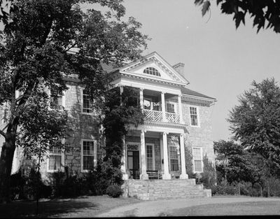
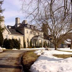
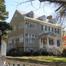
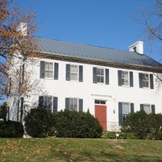
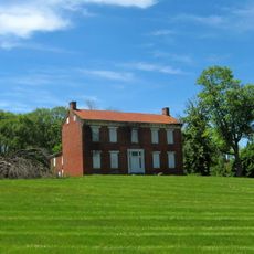
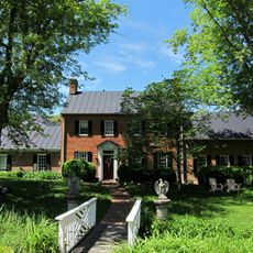
Annefield is a two-story stone house built around 1790 near Boyce, Virginia. The front elevation shows seven bays with Federal-style features, including an Ionic columned portico and decorative woodwork inside reflecting late 18th century design principles.

Matthew Page built the house in 1790 and named it after his wife Ann Randolph Meade. After his death in 1826, the property passed to Thomas Carter, whose son William Carter later became a poet and Confederate officer.

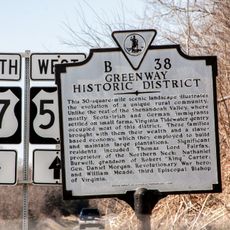
The name Annefield comes from Ann Randolph Meade, the wife of builder Matthew Page. The residents shaped the estate through their actions: Ann Page became known for her work against slavery and her efforts to educate people on the property.

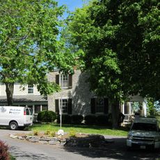
The house is private property and not open for tours, but you can view the exterior from the public road. Respect the owners' privacy and do not attempt to enter the grounds without permission.

The mistress of the house, Ann Randolph Meade Page, actively worked against slavery and coordinated the emigration of enslaved people to Liberia. Her efforts in the 1820s and 1830s made her a notable figure in the region's resistance to slavery.

The community of curious travelers

AroundUs brings together thousands of curated places, local tips, and hidden gems, enriched daily by 60,000 contributors worldwide.

Start exploring
Location
GPS coordinates
39.13170,-78.02470
Latest update
February 9, 2026 08:20
Around this place
Greenway Court
United States of America

Greenway Court

12.5 km
Holy Cross Abbey, Virginia
United States of America

Holy Cross Abbey, Virginia

12.9 km
Winchester National Cemetery
United States of America

Winchester National Cemetery

12.8 km
Abram's Delight
United States of America

Abram's Delight

12.5 km
Fairfield
United States of America

Fairfield

9.7 km
Burwell-Morgan Mill
United States of America

Burwell-Morgan Mill

7 km
Blandy Experimental Farm Historic District
United States of America

Blandy Experimental Farm Historic District

8.7 km
Scaleby
United States of America

Scaleby

4.7 km
High Banks
United States of America

High Banks

9.2 km
Long Marsh Run Rural Historic District
United States of America

Long Marsh Run Rural Historic District

10 km
White Post Historic District
United States of America

White Post Historic District

10.8 km
Berryville Historic District
United States of America

Berryville Historic District

4.3 km
Shentel Stadium
United States of America

Shentel Stadium

11.7 km
Bethel Memorial Church
United States of America

Bethel Memorial Church

11.6 km
Cleridge
United States of America

Cleridge

10.8 km
Josephine City School
United States of America

Josephine City School

4 km
Meadea
United States of America

Meadea

10.7 km
Glendale Farm
United States of America

Glendale Farm

11 km
Clermont
United States of America

Clermont

5.4 km
Josephine City Historic District
United States of America

Josephine City Historic District

3.9 km
Millbank
United States of America

Millbank

7 km
Boyce Historic District
United States of America

Boyce Historic District

5.3 km
Millwood Commercial Historic District
United States of America

Millwood Commercial Historic District

6.8 km
Chapel Rural Historic District
United States of America

Chapel Rural Historic District

2.8 km
Greenway Historic District
United States of America

Greenway Historic District

8.9 km
Valley Mill Farm
United States of America

Valley Mill Farm

7.6 km
Old Clarke County Courthouse
United States of America

Old Clarke County Courthouse

4.4 km
Orland E. White Research Arboretum
United States of America

Orland E. White Research Arboretum

8.4 km
Show the full map
« Annefield - human settlement in Virginia, United States of America » is provided by Around Us (aroundus.com). Images and texts are derived from Wikimedia project under a Creative Commons license. You are allowed to copy, distribute, and modify copies of this page, under the conditions set by the license, as long as this note is clearly visible.

Discover hidden gems everywhere you go!

From secret cafés to breathtaking viewpoints, skip the crowded tourist spots and find places that match your style. Our app makes it easy with voice search, smart filtering, route optimization, and insider tips from travelers worldwide. Download now for the complete mobile experience.

Around Us App Screenshot

A unique approach to discovering new places

Le Figaro

All the places worth exploring

France Info

A tailor-made excursion in just a few clicks

20 Minutes

Around Us
Travel Guide & Maps
Download

Send to your phone

QR Code
1

Open the camera app on your mobile.

2

Point at the QR code with your camera. A notification will appear.

3

Tap the notification to open the link.