Enable Location

We need your location to show you interesting places around you

Discover nearby places

Find interesting locations and hidden gems around you

Precise directions

Get accurate directions and distances to places

Your location is never shared with other users. It's only used when you tap the location button.

Virginia's Explore Park

Log in to your account

Start exploring — it's free

Trusted by 66,119 travelers worldwide

Continue with Google
Continue with Apple
or

We will send you a code to connect

By continuing, you accept our Terms and Conditions and our Privacy Policy

Check your inbox

We've sent a pincode in your inbox. Please enter the code below.

Virginia's Explore Park
Discussion Reviews 1 Photos
3.2k Popularity

Virginia's Explore Park, County park in Roanoke County, United States.

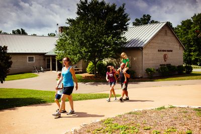
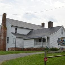
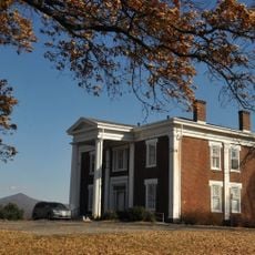
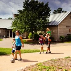
Virginia's Explore Park is a county park in Roanoke County set across forested hills with access to the river and views toward the Blue Ridge region. The grounds hold over 20 historic buildings that were moved here from other locations, along with trails, overnight accommodations, and outdoor activity areas.

Virginia bought this land in 1988, a few years after the state created the Virginia Recreational Facilities Authority to develop public recreation areas. The site was later shaped into a park that brought together relocated historic buildings and outdoor facilities.

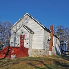
The Mountain Union Church and Brugh Tavern are two old structures that were taken apart and rebuilt on the park grounds. Stepping inside them gives a clear sense of how people in this part of Virginia once built and lived.

The park is reached via the Blue Ridge Parkway and offers cabins, yurts, and campsites for those who want to stay overnight. The terrain is hilly and uneven in places, so sturdy footwear makes the visit more comfortable.

Tree Top Quest, the aerial adventure course on the grounds, welcomes children from age 4, which is unusually young for this type of activity. This means families with small children can take part in rope challenges and zip-lines together, rather than waiting on the sidelines.

The community of curious travelers

AroundUs brings together thousands of curated places, local tips, and hidden gems, enriched daily by 60,000 contributors worldwide.

Start exploring
Location
Inception
1985
GPS coordinates
37.23830,-79.85190
Latest update
March 3, 2026 13:56
Around this place
Roanoke Star
United States of America

Roanoke Star

7.3 km
Roanoke Civic Center
United States of America

Roanoke Civic Center

8.8 km
Hotel Roanoke
United States of America

Hotel Roanoke

8.7 km
Taubman Museum of Art
United States of America

Taubman Museum of Art

8.6 km
O. Winston Link Museum
United States of America

O. Winston Link Museum

8.6 km
Wells Fargo Tower
United States of America

Wells Fargo Tower

8.7 km
United States of America

Mill Mountain Theatre

8.6 km
Jubal A. Early House
United States of America

Jubal A. Early House

8.8 km
Roanoke Downtown Historic District
United States of America

Roanoke Downtown Historic District

8.9 km
Buena Vista
United States of America

Buena Vista

6.9 km
Science Museum of Western Virginia
United States of America

Science Museum of Western Virginia

8.6 km
Roanoke City Market Historic District
United States of America

Roanoke City Market Historic District

8.6 km
Beth Israel Synagogue
United States of America

Beth Israel Synagogue

8.8 km
Mount Moriah Baptist Church and Cemetery
United States of America

Mount Moriah Baptist Church and Cemetery

8.1 km
First National Bank
United States of America

First National Bank

8.8 km
Belmont Methodist-Episcopal Church
United States of America

Belmont Methodist-Episcopal Church

7.7 km
Virginia Can Company-S.H. Heironimus Warehouse
United States of America

Virginia Can Company-S.H. Heironimus Warehouse

8.2 km
Roanoke City Firehouse No. 6
United States of America

Roanoke City Firehouse No. 6

7.5 km
William Byrd High School Historic District
United States of America

William Byrd High School Historic District

6.5 km
Crystal Spring Steam Pumping Station
United States of America

Crystal Spring Steam Pumping Station

8.3 km
Roanoke River and Railroad Historic District
United States of America

Roanoke River and Railroad Historic District

8.2 km
H. L. Lawson & Son Warehouse
United States of America

H. L. Lawson & Son Warehouse

8.1 km
Booth-Lovelace House
United States of America

Booth-Lovelace House

7.6 km
Roland E. Cook Elementary School
United States of America

Roland E. Cook Elementary School

5.8 km
Boxley-Sprinkle House
United States of America

Boxley-Sprinkle House

8.8 km
Riverland Historic District
United States of America

Riverland Historic District

7.6 km
Kids Square Children's Museum
United States of America

Kids Square Children's Museum

8.6 km
Explore Park Visitor Center
United States of America

Explore Park Visitor Center

9 m
Show the full map
Reviews
Share your experience

No review yet

Discussions
Start a discussion...

No discussion yet

« Virginia's Explore Park - County park in Roanoke County, United States » is provided by Around Us (aroundus.com). Images and texts are derived from Wikimedia project under a Creative Commons license. You are allowed to copy, distribute, and modify copies of this page, under the conditions set by the license, as long as this note is clearly visible.

Discover hidden gems everywhere you go!

From secret cafés to breathtaking viewpoints, skip the crowded tourist spots and find places that match your style. Our app makes it easy with voice search, smart filtering, route optimization, and insider tips from travelers worldwide. Download now for the complete mobile experience.

Around Us App Screenshot

A unique approach to discovering new places

Le Figaro

All the places worth exploring

France Info

A tailor-made excursion in just a few clicks

20 Minutes

Around Us
Travel Guide & Maps
Download

Send to your phone

QR Code
1

Open the camera app on your mobile.

2

Point at the QR code with your camera. A notification will appear.

3

Tap the notification to open the link.