Enable Location

We need your location to show you interesting places around you

Discover nearby places

Find interesting locations and hidden gems around you

Precise directions

Get accurate directions and distances to places

Your location is never shared with other users. It's only used when you tap the location button.

County Farm Park

Log in to your account

Start exploring — it's free

Trusted by 61,509 travelers worldwide

Continue with Google
Continue with Apple
or

We will send you a code to connect

By continuing, you accept our Terms and Conditions and our Privacy Policy

Check your inbox

We've sent a pincode in your inbox. Please enter the code below.

County Farm Park

County Farm Park, Public park in east Ann Arbor, United States.

Description

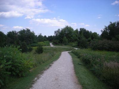
County Farm Park is a large recreational area in east Ann Arbor with walking trails, sports fields, and natural spaces for outdoor activities. Facilities include children's play areas, picnic pavilions, exercise stations, and multiple parking areas throughout the grounds.

History

The park was established in 1972 when former farmland was converted into a public recreational area managed by Washtenaw County Parks Commission. This transformation turned agricultural property into a modern community resource for the expanding city.

Culture

The park serves as a gathering place where neighbors come together for seasonal events and community celebrations throughout the year. These occasions help build connections between local residents and their surroundings.

Practical

The park is easily accessible from Platt Road with multiple parking areas for different sections and activities. Since the grounds spread widely, planning your route beforehand helps you make the most of your visit.

Did you know?

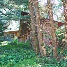
Britton Woods Nature Area contains a woodlot with native oak, hickory, cherry, maple, ash, ironwood, and hornbeam trees. This diverse forest setting offers a different walking experience compared to the park's more open recreational spaces.

Location
Location
Inception
1972
GPS coordinates
42.25556,-83.70556
Latest update
December 13, 2025 12:41

AroundUs brings together thousands of curated places, local tips, and hidden gems, enriched daily by 60,000 contributors worldwide. Discover all places nearby (Ann Arbor).

Around this place
University of Michigan Law School
United States of America

University of Michigan Law School

3.5 km
Gerald R. Ford Presidential Library
United States of America

Gerald R. Ford Presidential Library

3.6 km
Nichols Arboretum
United States of America

Nichols Arboretum

3.2 km
Ferry Field
United States of America

Ferry Field

3.3 km
University of Michigan Museum of Art
United States of America

University of Michigan Museum of Art

3.6 km
Michigan Union
United States of America

Michigan Union

3.7 km
William Palmer Residence
United States of America

William Palmer Residence

2.7 km
President's House, University of Michigan
United States of America

President's House, University of Michigan

3.5 km
David M. Dennison Building
United States of America

David M. Dennison Building

3.4 km
Detroit Observatory
United States of America

Detroit Observatory

3.6 km
Revel & Roll Bowling Alley
United States of America

Revel & Roll Bowling Alley

2.7 km
Stockwell Hall
United States of America

Stockwell Hall

3.4 km
Cobblestone Farm and Museum
United States of America

Cobblestone Farm and Museum

1.2 km
Beth Israel Congregation
United States of America

Beth Israel Congregation

1.9 km
University Towers
United States of America

University Towers

3.2 km
Michigan Alpha Chapter House of Phi Delta Theta
United States of America

Michigan Alpha Chapter House of Phi Delta Theta

3 km
Delta Upsilon Fraternity House
United States of America

Delta Upsilon Fraternity House

2.9 km
Stone School
United States of America

Stone School

1.5 km
Orrin White House
United States of America

Orrin White House

2.5 km
William and Elizabeth Muschenheim House
United States of America

William and Elizabeth Muschenheim House

1.3 km
Henry S. Frieze House
United States of America

Henry S. Frieze House

2.7 km
William Anderson House
United States of America

William Anderson House

1.6 km
Floyd R. Mechem House
United States of America

Floyd R. Mechem House

2.8 km
Bell-Spalding House
United States of America

Bell-Spalding House

1.5 km
Robert C. and Bettie J. Metcalf House
United States of America

Robert C. and Bettie J. Metcalf House

1.5 km
Karl D. Gregory Cooperative House
United States of America

Karl D. Gregory Cooperative House

2.5 km
University of Michigan Historical Marker
United States of America

University of Michigan Historical Marker

3.6 km
Martha Cook Building Historical Marker
United States of America

Martha Cook Building Historical Marker

3.4 km
Show the full map
« County Farm Park - Public park in east Ann Arbor, United States » is provided by Around Us (aroundus.com). Images and texts are derived from Wikimedia project under a Creative Commons license. You are allowed to copy, distribute, and modify copies of this page, under the conditions set by the license, as long as this note is clearly visible.

Discover hidden gems everywhere you go!

From secret cafés to breathtaking viewpoints, skip the crowded tourist spots and find places that match your style. Our app makes it easy with voice search, smart filtering, route optimization, and insider tips from travelers worldwide. Download now for the complete mobile experience.

Around Us App Screenshot

A unique approach to discovering new places

Le Figaro

All the places worth exploring

France Info

A tailor-made excursion in just a few clicks

20 Minutes

Around Us
Travel Guide & Maps
Download

Send to your phone

QR Code
1

Open the camera app on your mobile.

2

Point at the QR code with your camera. A notification will appear.

3

Tap the notification to open the link.