Enable Location

We need your location to show you interesting places around you

Discover nearby places

Find interesting locations and hidden gems around you

Precise directions

Get accurate directions and distances to places

Your location is never shared with other users. It's only used when you tap the location button.

Pelham Mills Site

Log in to your account

Start exploring — it's free

Trusted by 62,123 travelers worldwide

Continue with Google
Continue with Apple
or

We will send you a code to connect

By continuing, you accept our Terms and Conditions and our Privacy Policy

Check your inbox

We've sent a pincode in your inbox. Please enter the code below.

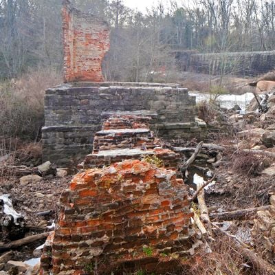
Pelham Mills Site, Archaeological site in Greenville County, South Carolina

Pelham Mills Site is an archaeological location along the Enoree River where stone foundations, brick pilings, and two remaining steam smokestacks mark what was once an active textile production facility. The site spans several acres and reveals through its physical remains the industrial past of the area.

The textile mill was established in 1820 and was the first of its kind in the region, changing hands multiple times during its long operating period. Operations ceased in 1935 after decades of shaping the local economy.

The mill system employed local families who received payment in tokens for the mill store, creating a contained economic structure within the manufacturing community.

The site is accessible with interpretive signage that explains the former production methods and daily operations at the mill. Visitors should expect uneven terrain and structural remnants visible while exploring the grounds.

A stone dam crosses the river with six surviving sluice gates that once controlled water flow for powering the mill machinery. This structure reflects the engineering approach of the facility and remains one of the less noticed but well-preserved features of the site.

The community of curious travelers

AroundUs brings together thousands of curated places, local tips, and hidden gems, enriched daily by 60,000 contributors worldwide.

Start exploring
GPS coordinates
34.85710,-82.22660
Latest update
December 14, 2025 18:04
Around this place
Paris Mountain State Park
United States of America

Paris Mountain State Park

14.8 km
Greenville Wildlife Park
United States of America

Greenville Wildlife Park

1258.5 km
Broad Margin
United States of America

Broad Margin

15.1 km
Isaqueena
United States of America

Isaqueena

13.4 km
Bob Jones University Museum and Gallery
United States of America

Bob Jones University Museum and Gallery

12.5 km
Conestee Nature Preserve
United States of America

Conestee Nature Preserve

14.9 km
Woodside Cotton Mill Village Historic District
United States of America

Woodside Cotton Mill Village Historic District

9 km
First Baptist Simpsonville
United States of America

First Baptist Simpsonville

13.3 km
Greer Post Office
United States of America

Greer Post Office

9 km
Fountain Fox Beattie House
United States of America

Fountain Fox Beattie House

14.9 km
Arthur Barnwell House
United States of America

Arthur Barnwell House

269 m
Davis Field House
United States of America

Davis Field House

12.5 km
Hurricane Tavern
United States of America

Hurricane Tavern

11.3 km
Gilreath's Mill
United States of America

Gilreath's Mill

13.8 km
Burdette Building
United States of America

Burdette Building

13.6 km
Davenport House
United States of America

Davenport House

8.8 km
R. Perry Turner House
United States of America

R. Perry Turner House

9.4 km
Pettigru Street Historic District
United States of America

Pettigru Street Historic District

14.9 km
McMakin's Tavern
United States of America

McMakin's Tavern

14.6 km
Josiah Kilgore House
United States of America

Josiah Kilgore House

15.1 km
James M. Davis House
United States of America

James M. Davis House

578 m
William Bates House
United States of America

William Bates House

1.3 km
Hugh Aiken House
United States of America

Hugh Aiken House

15.1 km
Robert G. Turner House
United States of America

Robert G. Turner House

9.5 km
Louie James House
United States of America

Louie James House

9.3 km
East Park Historic District
United States of America

East Park Historic District

15.1 km
Reidville Academy Faculty House
United States of America

Reidville Academy Faculty House

10.3 km
Rodeheaver Auditorium
United States of America

Rodeheaver Auditorium

12.6 km
Show the full map
« Pelham Mills Site - Archaeological site in Greenville County, South Carolina » is provided by Around Us (aroundus.com). Images and texts are derived from Wikimedia project under a Creative Commons license. You are allowed to copy, distribute, and modify copies of this page, under the conditions set by the license, as long as this note is clearly visible.

Discover hidden gems everywhere you go!

From secret cafés to breathtaking viewpoints, skip the crowded tourist spots and find places that match your style. Our app makes it easy with voice search, smart filtering, route optimization, and insider tips from travelers worldwide. Download now for the complete mobile experience.

Around Us App Screenshot

A unique approach to discovering new places

Le Figaro

All the places worth exploring

France Info

A tailor-made excursion in just a few clicks

20 Minutes

Around Us
Travel Guide & Maps
Download

Send to your phone

QR Code
1

Open the camera app on your mobile.

2

Point at the QR code with your camera. A notification will appear.

3

Tap the notification to open the link.