Enable Location

We need your location to show you interesting places around you

Discover nearby places

Find interesting locations and hidden gems around you

Precise directions

Get accurate directions and distances to places

Your location is never shared with other users. It's only used when you tap the location button.

Hubbard Park

Log in to your account

Start exploring — it's free

Trusted by 65,224 travelers worldwide

Continue with Google
Continue with Apple
or

We will send you a code to connect

By continuing, you accept our Terms and Conditions and our Privacy Policy

Check your inbox

We've sent a pincode in your inbox. Please enter the code below.

Hubbard Park
Discussion Reviews 1 Photos
3.6k Popularity

Hubbard Park, Public park in Montpelier, Vermont, US

Hubbard Park is a forested recreational area on the edge of downtown Montpelier, Vermont, with walking trails, open meadows, and wooded hillsides. The trails wind through a mix of dense tree cover and open clearings, offering a range of terrain within a short walk from the city center.

The park was founded in 1899 when John E. Hubbard donated land to the city of Montpelier for public use. It grew over the following decades through additional land gifts from other donors.

The park is a gathering spot where Montpelier residents walk, picnic, and spend time outdoors throughout the year. On warm days, the meadows and shaded paths fill with people of all ages enjoying the open space.

The park can be entered from several points, with parking near Winter Street and Spring Street. It is easy to reach on foot from the center of Montpelier, making it a convenient stop at any time of day.

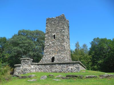
An observation tower at the park's highest point offers a clear view of the Vermont State House and the hills beyond the city. The tower was added after the original donation and was not part of the land gift that created the park.

The community of curious travelers

AroundUs brings together thousands of curated places, local tips, and hidden gems, enriched daily by 60,000 contributors worldwide.

Start exploring
Inception
1899
GPS coordinates
44.26839,-72.57678
Latest update
March 3, 2026 14:00
Around this place
Vermont State House
United States of America

Vermont State House

722 m
The Pavilion
United States of America

The Pavilion

828 m
Socialist Labor Party Hall
United States of America

Socialist Labor Party Hall

9.6 km
Christ Episcopal Church
United States of America

Christ Episcopal Church

773 m
Saint Augustine Church, Montpelier
United States of America

Saint Augustine Church, Montpelier

1.1 km
Vermont Granite Museum
United States of America

Vermont Granite Museum

7.7 km
Montpelier City Hall
United States of America

Montpelier City Hall

1 km
Athenwood and the Thomas W. Wood Studio
United States of America

Athenwood and the Thomas W. Wood Studio

1.4 km
Montpelier Historic District
United States of America

Montpelier Historic District

780 m
Saint Monica's Church, Barre
United States of America

Saint Monica's Church, Barre

9.4 km
College Hall
United States of America

College Hall

1.6 km
Aldrich Public Library
United States of America

Aldrich Public Library

9.9 km
National Clothespin Factory
United States of America

National Clothespin Factory

1.9 km
Barre City Hall and Opera House
United States of America

Barre City Hall and Opera House

9.9 km
Coburn Covered Bridge
United States of America

Coburn Covered Bridge

9.8 km
Lover's Lane Bridge
United States of America

Lover's Lane Bridge

10.2 km
Union Co-operative Store Bakery
United States of America

Union Co-operative Store Bakery

9.5 km
Scampini Block
United States of America

Scampini Block

9.4 km
Middlesex–Winooski River Bridge
United States of America

Middlesex–Winooski River Bridge

10.4 km
Barre Downtown Historic District
United States of America

Barre Downtown Historic District

9.9 km
E. L. Smith Roundhouse Granite Shed
United States of America

E. L. Smith Roundhouse Granite Shed

9.7 km
Beck and Beck Granite Shed
United States of America

Beck and Beck Granite Shed

9.5 km
East Village Meetinghouse
United States of America

East Village Meetinghouse

7.1 km
Joshua Twing Gristmill
United States of America

Joshua Twing Gristmill

8.8 km
Parley Davis House
United States of America

Parley Davis House

4.1 km
Currier Park Historic District
United States of America

Currier Park Historic District

10.1 km
Chauncey B. Leonard House
United States of America

Chauncey B. Leonard House

6.4 km
Capitol Theatre
United States of America

Capitol Theatre

840 m
Show the full map
Reviews
Share your experience

No review yet

Discussions
Start a discussion...

No discussion yet

« Hubbard Park - Public park in Montpelier, Vermont, US » is provided by Around Us (aroundus.com). Images and texts are derived from Wikimedia project under a Creative Commons license. You are allowed to copy, distribute, and modify copies of this page, under the conditions set by the license, as long as this note is clearly visible.

Discover hidden gems everywhere you go!

From secret cafés to breathtaking viewpoints, skip the crowded tourist spots and find places that match your style. Our app makes it easy with voice search, smart filtering, route optimization, and insider tips from travelers worldwide. Download now for the complete mobile experience.

Around Us App Screenshot

A unique approach to discovering new places

Le Figaro

All the places worth exploring

France Info

A tailor-made excursion in just a few clicks

20 Minutes

Around Us
Travel Guide & Maps
Download

Send to your phone

QR Code
1

Open the camera app on your mobile.

2

Point at the QR code with your camera. A notification will appear.

3

Tap the notification to open the link.