Enable Location

We need your location to show you interesting places around you

Discover nearby places

Find interesting locations and hidden gems around you

Precise directions

Get accurate directions and distances to places

Your location is never shared with other users. It's only used when you tap the location button.

Grindstone City Historic District

Log in to your account

Start exploring — it's free

Trusted by 62,012 travelers worldwide

Continue with Google
Continue with Apple
or

We will send you a code to connect

By continuing, you accept our Terms and Conditions and our Privacy Policy

Check your inbox

We've sent a pincode in your inbox. Please enter the code below.

Grindstone City Historic District, Historic district in Port Austin Township, United States

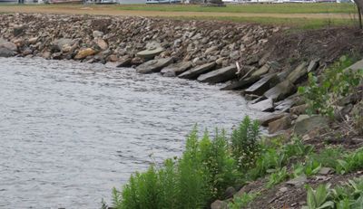
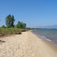
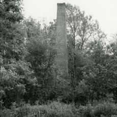
Grindstone City Historic District is an industrial area along Lake Huron in Port Austin Township where stone quarry operations took place between the 1800s and early 1900s. The site includes weathered stone structures, worked quarry edges, and two jetties extending into the water that mark the former production center.

A captain founded a quarry here in 1833 that quickly became a major employer, supporting around 200 workers by 1888. Production ended during the Great Depression when demand for grindstones dropped sharply.

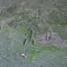
The quarry industry shaped daily life here for generations, and visitors can still see the massive stone blocks and worker buildings that reflect this industrial heritage. The architecture of these structures reveals the craft-based nature of the grindstone trade, with sturdy stone buildings defining the shoreline.

The site is easy to walk through and offers open spaces to explore the old structures and stone blocks. Visitors should bring wind-resistant clothing as the area sits open toward the lake and can be breezy.

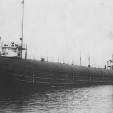
The stone blocks came in different sizes, ranging from small whetstones to massive examples weighing several tons that were loaded onto ships. These stones supplied mills and workshops across North America until the operations closed during the economic downturn.

The community of curious travelers

AroundUs brings together thousands of curated places, local tips, and hidden gems, enriched daily by 60,000 contributors worldwide.

Start exploring
GPS coordinates
44.05444,-82.89806
Latest update
December 12, 2025 14:21
Around this place
Turnip Rock
United States of America

Turnip Rock

5.1 km
Sanilac Petroglyphs Historic State Park
United States of America

Sanilac Petroglyphs Historic State Park

45.2 km
Port Crescent State Park
United States of America

Port Crescent State Park

13.7 km
SS Clifton
United States of America

SS Clifton

42.9 km
Pointe aux Barques Light
United States of America

Pointe aux Barques Light

9.1 km
Charity Island Light
United States of America

Charity Island Light

43.5 km
Port Austin Light
United States of America

Port Austin Light

7.5 km
Harbor Beach Light
United States of America

Harbor Beach Light

31.6 km
St. Peter's Lutheran Church Kinde, Michigan
United States of America

St. Peter's Lutheran Church Kinde, Michigan

14.9 km
Grice House Museum
United States of America

Grice House Museum

29.6 km
Huron City Historic District
United States of America

Huron City Historic District

5.9 km
Charles G. Learned House
United States of America

Charles G. Learned House

7.8 km
Albert E. Sleeper House
United States of America

Albert E. Sleeper House

29.4 km
St. John's Lutheran Church
United States of America

St. John's Lutheran Church

19.2 km
Frank Murphy Birthplace
United States of America

Frank Murphy Birthplace

30.8 km
First Methodist Episcopal Church
United States of America

First Methodist Episcopal Church

19.4 km
Masonic Temple
United States of America

Masonic Temple

19.4 km
Frederick H. and Elizabeth Stafford House
United States of America

Frederick H. and Elizabeth Stafford House

19.3 km
W. R. Stafford Worker's House
United States of America

W. R. Stafford Worker's House

19.7 km
William R. Stafford House
United States of America

William R. Stafford House

19.4 km
Bay Port Historic Commercial Fishing District
United States of America

Bay Port Historic Commercial Fishing District

44.2 km
Smith-Culhane House
United States of America

Smith-Culhane House

7.8 km
Winsor and Snover Bank Building
United States of America

Winsor and Snover Bank Building

7.7 km
Isaac Leuty House
United States of America

Isaac Leuty House

19.4 km
W. R. Stafford Planing Mill Site
United States of America

W. R. Stafford Planing Mill Site

19.8 km
Caseville Harbor Light
United States of America

Caseville Harbor Light

32.9 km
Bad Axe Theatre
United States of America

Bad Axe Theatre

29.2 km
Blue Water Lanes
United States of America

Blue Water Lanes

30.3 km
Show the full map
« Grindstone City Historic District - Historic district in Port Austin Township, United States » is provided by Around Us (aroundus.com). Images and texts are derived from Wikimedia project under a Creative Commons license. You are allowed to copy, distribute, and modify copies of this page, under the conditions set by the license, as long as this note is clearly visible.

Discover hidden gems everywhere you go!

From secret cafés to breathtaking viewpoints, skip the crowded tourist spots and find places that match your style. Our app makes it easy with voice search, smart filtering, route optimization, and insider tips from travelers worldwide. Download now for the complete mobile experience.

Around Us App Screenshot

A unique approach to discovering new places

Le Figaro

All the places worth exploring

France Info

A tailor-made excursion in just a few clicks

20 Minutes

Around Us
Travel Guide & Maps
Download

Send to your phone

QR Code
1

Open the camera app on your mobile.

2

Point at the QR code with your camera. A notification will appear.

3

Tap the notification to open the link.