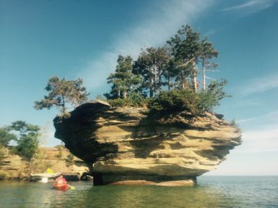
Turnip Rock, Rock formation in Huron County, United States.
Turnip Rock is a limestone formation in Lake Huron with a top much wider than its narrow stem, rising roughly 6 meters (20 feet) above the waterline. A slender column links the upper platform to the lakebed, giving the structure a top-heavy silhouette that recalls an upside-down pear.
Thousands of years of wave action carved out the limestone base below the waterline while leaving the upper mass intact. The scouring continued until the mid‑twentieth century, when steps were taken to prevent total collapse.
This formation takes its name from the vegetable-like profile it cuts against the water. The natural landmark draws photographers and paddlers seeking unusual perspectives on Lake Huron.
A kayak or canoe is necessary to reach the rock formation, as the surrounding shoreline is private and off‑limits. The paddle from Port Austin covers roughly 11 kilometers (7 miles) total and requires calm lake conditions.
A concrete collar at the waterline shields the base from further wave erosion and keeps the structure stable. This reinforcement remains barely visible to paddlers and preserves the natural appearance of the limestone.
The community of curious travelers
AroundUs brings together thousands of curated places, local tips, and hidden gems, enriched daily by 60,000 contributors worldwide.