Portage Brule Rapids Protected Area, protected area in British Columbia, Canada
Location: Northern Rockies Regional Municipality
GPS coordinates: 59.65056,-126.90472
Latest update: November 24, 2023 23:42
Liard River Hot Springs Provincial Park
54.9 km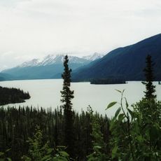
Muncho Lake Provincial Park
73.7 km
Smith River Falls – Fort Halkett Provincial Park
26.6 km
Hyland River Provincial Park
77.9 km
Horneline Creek Provincial Park
75 km
Coal River Springs Territorial Park
62.5 km
Liard River West Corridor Provincial Park
59.9 km
Liard River Corridor Provincial Park
94.5 km
Smith River Ecological Reserve
22 km
Grayling River Hot Springs Ecological Reserve
76.1 km
Mountain Portage Rapids
10.4 km
Portage Brule Rapids Ecological Reserve
1 km
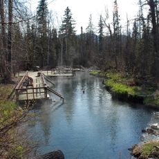
Liard Hot Springs
51.4 km
Rapids of the Drowned
93.4 km
Liard River Corridor Protected Area
60.8 km
Cranberry Rapids
14.1 km
Portage Brûlé Rapids
2.1 km
Fourmile Rapids
96 km
Twomile Rapids
93.8 km
Liard river
37.7 km
Waterfall
86.1 km
Boulder Canyon Trail
88.5 km
Scenic viewpoint
92.9 km
Mineral Lick Trail
79.1 km
Waterfall
55.9 km
Liard River Hot Springs
51.5 km
Teeter Creek Trail
43.8 km
Scenic viewpoint
101.1 kmReviews
Visited this place? Tap the stars to rate it and share your experience / photos with the community! Try now! You can cancel it anytime.
Discover hidden gems everywhere you go!
From secret cafés to breathtaking viewpoints, skip the crowded tourist spots and find places that match your style. Our app makes it easy with voice search, smart filtering, route optimization, and insider tips from travelers worldwide. Download now for the complete mobile experience.

A unique approach to discovering new places❞
— Le Figaro
All the places worth exploring❞
— France Info
A tailor-made excursion in just a few clicks❞
— 20 Minutes