Chest opened
+${chestReward.xp} XP
Explorer
NOUVEAU ×${chestReward.collectible.quantity}
tapez pour fermer
Chest locked

Open chests in the app

Around Us is built for your phone — chests unlock when you walk, explore and capture nearby places.

Enable Location

We need your location to show you interesting places around you

Discover nearby places

Find interesting locations and hidden gems around you

Precise directions

Get accurate directions and distances to places

Your location is never shared with other users. It's only used when you tap the location button.

Log in to your account

Start exploring — it's free

Trusted by 72,990 travelers worldwide

Continue with Google
Continue with Apple
or

We will send you a code to connect

By continuing, you accept our Terms and Conditions and our Privacy Policy

Check your inbox

We've sent a pincode in your inbox. Please enter the code below.

Grillenburger Dreieck
Discussion Reviews Photo
2.7k Popularity

Grillenburger Dreieck, tor wyścigowy (Niemcy)

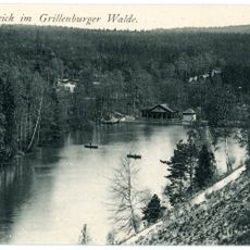
Grillenburger Dreieck was a racing track in a wooded area near Tharandt, used for motorcycle and car races from 1927 to 1931. The roughly 14.5 kilometer course ran in a triangular shape through forests between Grillenburg, Naundorf, and Klingenberg-Colmnitz, offering a challenging layout with curves and varied terrain that tested the skills of drivers and riders.

The track opened in 1927 and hosted regular motorcycle and car races until 1931. After that year, it became known as the first Sachsenring, continuing the region's motorsport tradition before racing eventually moved to other locations.

The triangular shape of the course, which ran between the villages of Grillenburg, Naundorf, and Klingenberg-Colmnitz, defined the name Grillenburger Dreieck. The location served as a gathering place where racing enthusiasts and spectators came together regularly to share their passion for motorsport and maintain local traditions tied to early speed racing.

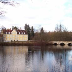
The old course is easily accessible today via local roads and forest paths, with parking available nearby. Hikers and cyclists can discover the old track sections with the help of information boards, particularly at the Pöppelmann Bridge in Grillenburg, where a detailed overview of the site's history is displayed.

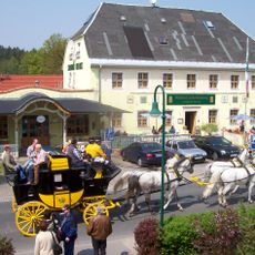
Today, commemorative drives take place regularly here, where enthusiasts travel the historical course at a gentle pace with vintage motorcycles and cars from the 1920s to 1970s. These special events connect the past with the present and allow visitors to experience the site's history firsthand.

The community of curious travelers

AroundUs brings together thousands of curated places, local tips, and hidden gems, enriched daily by 60,000 contributors worldwide.

Start exploring
Location
GPS coordinates
50.95220,13.50520
Latest update
February 11, 2026 22:04
Reviews
Share your experience

No review yet

Discussions
Start a discussion...

No discussion yet

« Grillenburger Dreieck - tor wyścigowy (Niemcy) » is provided by Around Us (aroundus.com). Images and texts are derived from Wikimedia project under a Creative Commons license. You are allowed to copy, distribute, and modify copies of this page, under the conditions set by the license, as long as this note is clearly visible.

Discover hidden gems everywhere you go!

From secret cafés to breathtaking viewpoints, skip the crowded tourist spots and find places that match your style. Our app makes it easy with voice search, smart filtering, route optimization, and insider tips from travelers worldwide. Download now for the complete mobile experience.

Around Us App Screenshot

A unique approach to discovering new places

Le Figaro

All the places worth exploring

France Info

A tailor-made excursion in just a few clicks

20 Minutes

Around Us
Travel Guide & Maps
Download

Send to your phone

QR Code
1

Open the camera app on your mobile.

2

Point at the QR code with your camera. A notification will appear.

3

Tap the notification to open the link.