Enable Location

We need your location to show you interesting places around you

Discover nearby places

Find interesting locations and hidden gems around you

Precise directions

Get accurate directions and distances to places

Your location is never shared with other users. It's only used when you tap the location button.

Queen Elizabeth II Bridge

Log in to your account

Start exploring — it's free

Trusted by 62,177 travelers worldwide

Continue with Google
Continue with Apple
or

We will send you a code to connect

By continuing, you accept our Terms and Conditions and our Privacy Policy

Check your inbox

We've sent a pincode in your inbox. Please enter the code below.

Queen Elizabeth II Bridge

Queen Elizabeth II Bridge, Cable-stayed bridge in Dartford, England

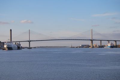
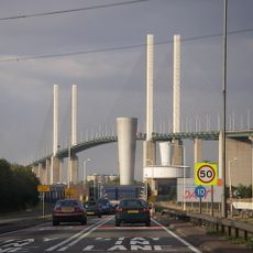
The Queen Elizabeth II Bridge is a cable-stayed structure made of steel that spans approximately 2,900 meters across the River Thames, linking Dartford in Kent with Thurrock in Essex. The bridge features distinctive pylons and carries thousands of vehicles daily.

The bridge opened on October 30, 1991, replacing the ferry service that previously connected the two banks. It became a major milestone in regional transport development and shaped infrastructure across Southeast England.

The bridge marks the first Thames crossing east of London and transformed travel patterns across Southeast England. It became a symbol of regional connection, showing how this route shapes commerce and daily movement for local communities.

The bridge operates under the Dart Charge toll system, with free passage available during specific hours. Check details before traveling to avoid delays or unexpected charges.

Engineer Helmut Homberg, who led the project, passed away just one month after the bridge's opening. His legacy remains tied to this final major engineering work before his death.

The community of curious travelers

AroundUs brings together thousands of curated places, local tips, and hidden gems, enriched daily by 60,000 contributors worldwide.

Start exploring
Location
Location
Inception
October 30, 1991
Official opening
October 30, 1991
Length
2,872 m
Made from material
steel
Part of
Dartford Crossing
GPS coordinates
51.46444,0.25833
Latest update
December 7, 2025 20:46
Around this place
Dartford Crossing
United Kingdom

Dartford Crossing

35 m
Ingress Abbey
United Kingdom

Ingress Abbey

2.5 km
Church of the Holy Trinity
United Kingdom

Church of the Holy Trinity

3.5 km
Rainham Marshes Nature Reserve
United Kingdom

Rainham Marshes Nature Reserve

3.7 km
Stone Castle
United Kingdom

Stone Castle

2.7 km
St Clement's Church
United Kingdom

St Clement's Church

2.5 km
Orchard Theatre
United Kingdom

Orchard Theatre

3.5 km
Purfleet Chalk Pits
United Kingdom

Purfleet Chalk Pits

2.1 km
Lion Pit
United Kingdom

Lion Pit

3.5 km
West Thurrock Lagoon and Marshes
United Kingdom

West Thurrock Lagoon and Marshes

1.6 km
Church of St Mary
United Kingdom

Church of St Mary

2.3 km
Church of St Mary
United Kingdom

Church of St Mary

1.7 km
War Memorial in the Churchyard of St Alban's Church
United Kingdom

War Memorial in the Churchyard of St Alban's Church

3 km
Church House
United Kingdom

Church House

2.8 km
Stoneness Light
United Kingdom

Stoneness Light

1.6 km
Martyr's Monument In St Edmund's Chartered Graveyard
United Kingdom

Martyr's Monument In St Edmund's Chartered Graveyard

3.3 km
The Wat Tyler Public House
United Kingdom

The Wat Tyler Public House

3.5 km
Coal Duty Boundary Marker (On Foreshore, At Mouth Of River Darenth, West Bank)
United Kingdom

Coal Duty Boundary Marker (On Foreshore, At Mouth Of River Darenth, West Bank)

3.4 km
St Stephen's Church
United Kingdom

St Stephen's Church

2.8 km
The Bridge House
United Kingdom

The Bridge House

3.5 km
Clock Tower And Attached Walls
United Kingdom

Clock Tower And Attached Walls

3 km
Government Powder Magazine
United Kingdom

Government Powder Magazine

3 km
Mortuary Chapel At Watling Street Burial Ground
United Kingdom

Mortuary Chapel At Watling Street Burial Ground

3 km
Temple Hill Library
United Kingdom

Temple Hill Library

2.6 km
Remains Of Priory Walls In Victoria Road, Kingsfield Terrace And Priory Lane, Including The Doorway In Kingsfield Terrace
United Kingdom

Remains Of Priory Walls In Victoria Road, Kingsfield Terrace And Priory Lane, Including The Doorway In Kingsfield Terrace

3.5 km
Milestone Situated At Junction With Knockhall Chase
United Kingdom

Milestone Situated At Junction With Knockhall Chase

2.5 km
Stone Park War Memorial, Kent
United Kingdom

Stone Park War Memorial, Kent

2.2 km
Milestone, London Road, E side of Lingfield Avenue, opp. Milestone Road
United Kingdom

Milestone, London Road, E side of Lingfield Avenue, opp. Milestone Road

2.7 km
Show the full map
« Queen Elizabeth II Bridge - Cable-stayed bridge in Dartford, England » is provided by Around Us (aroundus.com). Images and texts are derived from Wikimedia project under a Creative Commons license. You are allowed to copy, distribute, and modify copies of this page, under the conditions set by the license, as long as this note is clearly visible.

Discover hidden gems everywhere you go!

From secret cafés to breathtaking viewpoints, skip the crowded tourist spots and find places that match your style. Our app makes it easy with voice search, smart filtering, route optimization, and insider tips from travelers worldwide. Download now for the complete mobile experience.

Around Us App Screenshot

A unique approach to discovering new places

Le Figaro

All the places worth exploring

France Info

A tailor-made excursion in just a few clicks

20 Minutes

Around Us
Travel Guide & Maps
Download

Send to your phone

QR Code
1

Open the camera app on your mobile.

2

Point at the QR code with your camera. A notification will appear.

3

Tap the notification to open the link.